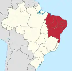
Northeast Region, Brazil
The Northeast Region of Brazil (Portuguese: Região Nordeste do Brasil) is one of the five geographical regions of Brazil defined by the Brazilian Institute of Geography and Statistics in 1969. It is the third largest region, corresponding to 18% of the national territory, and the second in population.
Northeast Region
Região Nordeste | |
|---|---|
 | |
| Coordinates: 12°58′S 38°31′W | |
| Country | Brazil |
| Largest cities | Salvador (by city proper) Recife (by metro pop.) Fortaleza (by pop. density) |
| States | |
| Area | |
| • Region | 1,558,196 km2 (601,623 sq mi) |
| • Rank | 3rd |
| Population | |
| • Region | 57,374,243 |
| • Rank | 2nd |
| • Density | 37/km2 (95/sq mi) |
| • Rank | 3rd |
| • Urban | 71% |
| GDP | |
| • Year | 2014 estimate |
| • Total | R$805,099,000,000 (3rd) |
| • Per capita | R$14,329.13 (5th) |
| HDI | |
| • Year | 2014 |
| • Category | 0.710 – high (5th) |
| • Life expectancy | 69 years (5th) |
| • Infant mortality | 33.2 per 1,000 (1st) |
| • Literacy | 85,2% (5th) |
| Time zones | UTC−02:00 (FNT) |
| UTC−03:00 (BRT) | |
Geography
The Northeast Region has an area of 1,554,291.31 km2 (600,115.23 sq mi). It is the region of the country with the longest coastline.
The climate in the region is very hot all the year long; tropical near the coast and semi-arid in the interior; semi-equatorial in the far west of the region. The vegetation mainly desert-like, with tropical forests along the coast and in the west and savanna-like vegetation, known as the Cerrado. in the southwest.
The Northeast Region is between 01° 02' 30" of latitude north and 18° 20' 07" of latitude south and between 34° 47' 30" and 48° 45' 24" of longitude west. It borders to the north and east with the Atlantic Ocean; to the south with the Minas Gerais and Espírito Santo states; and to west with the Pará, Tocantins and Goiás states.
Places next to Northeast Region, Brazil | ||||||||||
|---|---|---|---|---|---|---|---|---|---|---|
| ||||||||||
The main rivers in the region are the São Francisco and the Parnaíba rivers; they have many tributaries.
Mountains
The highest point in the Northeast Region is Pico do Barbado (13°17′47″S 41°54′28″W) at 2,033 m (6,670 ft). Pico do Barbado is the highest summit of the larger Serra do Barbado, in the Chapada Diamantina, in Bahia.[1]
The highest point of the different states of the North Region are:[2]
| Department | Mountain | Elevation |
|---|---|---|
| Alagoas | Pico 844 (Serra Santa Cruz) | 844 m (2,769 ft) |
| Bahia | Pico do Barbado (Serra do Barbado) | 2,033 m (6,670 ft) |
| Ceará | Pico Serra Branca | 1,154 m (3,786 ft) |
| Maranhão | Pico 804 (Chapada das Mangabeiras) | 804 m (2,638 ft) |
| Paraíba | Pico do Jabre | 1,197 m (3,927 ft) |
| Pernambuco | Pico 1195 (Serra da Boa Vista) | 1,195 m (3,921 ft) |
| Piauí | Pico 865 (Serra Grande) | 865 m (2,838 ft) |
| Rio Grande do Norte | Pico 868 (Serra do Coqueiro) | 868 m (2,848 ft) |
| Sergipe | Pico 742 (Serra Negra) | 742 m (2,434 ft) |
States
This region is formed of nine states: Alagoas, Bahia, Ceará, Maranhão, Paraíba, Pernambuco, Piauí, Rio Grande do Norte and Sergipe.
| Code | State | Capital | Municipalities | Population[3] (2016) | Area[4] (km2) | Density (inh./km2) |
|---|---|---|---|---|---|---|
| BR-AL | Maceió | 102 | 3,358,963 | 27,848.16 | 120.6 | |
| BR-BA | Salvador | 63 | 15,276,566 | 564,732.64 | 27.1 | |
| BR-CE | Fortaleza | 184 | 8,963,663 | 148,887.63 | 60.2 | |
| BR-MA | São Luís | 217 | 6,954,036 | 331,936.96 | 20.9 | |
| BR-PB | João Pessoa | 223 | 3,999,415 | 56,468.43 | 70.8 | |
| BR-PE | Recife | 185 | 9,410,336 | 98,076.00 | 95.9 | |
| BR-PI | Teresina | 224 | 3,212,180 | 251,611.93 | 12.8 | |
| BR-RN | Natal | 167 | 3,474,998 | 52,811.11 | 65.8 | |
| BR-SE | Aracaju | 75 | 2,265,779 | 21,918.45 | 103.4 | |
| Total | 1,440 | 56,915,936 | 1,554,291.31 | 36.6 | ||
Population
As of 1 July 2016, the Northeast region had a population of 56,915,936,[3] for a population density of 36.6 inhabitants/km2.
The most important municipalities of the North Region are:
| Rank | Municipality | State | Population | Rank | City | State | Population |
|---|---|---|---|---|---|---|---|
| 1 | Salvador | Bahia | 2,938,092 | 11 | Feira de Santana | Bahia | 622,639 |
| 2 | Fortaleza | Ceará | 2,609,716 | 12 | Campina Grande | Paraíba | 407,754 |
| 3 | Recife | Pernambuco | 1,625,583 | 13 | Olinda | Pernambuco | 390,144 |
| 4 | São Luís | Maranhão | 1,082,935 | 14 | Caucaia | Ceará | 358,164 |
| 5 | Maceió | Alagoas | 1,021,709 | 15 | Caruaru | Pernambuco | 351,686 |
| 6 | Natal | Rio Grande do Norte | 877,662 | 16 | Vitória da Conquista | Bahia | 346,069 |
| 7 | Teresina | Piauí | 847,430 | 17 | Petrolina | Pernambuco | 337,683 |
| 8 | João Pessoa | Paraíba | 801,718 | 18 | Paulista | Pernambuco | 325,590 |
| 9 | Jaboatão dos Guararapes | Pernambuco | 691,125 | 19 | Camaçari | Bahia | 292,074 |
| 10 | Aracaju | Sergipe | 641,523 | 20 | Mossoró | Rio Grande do Norte | 291,937 |
.jpg.webp) Salvador
Salvador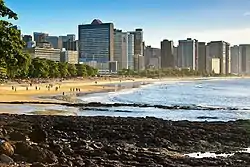 Fortaleza
_-_Recife_-_Pernambuco%252C_Brasil.jpg.webp) Recife
Recife São Luís
References
- "Serra do Barbado, Brazil". Peakbagger.com. Retrieved 20 February 2017.
- "Brazil State High Points". Peakbagger.com. Retrieved 20 February 2017.
- "Estimativas da População Residente no Brasil e Unidades da Federaçã com Data de Referencia en 1o de julho de 2016" (PDF) (in Portuguese). Instituto Brasileiro de Geografia e Estatística (IBGE). Retrieved 20 January 2017.
- "Área Territorial Brasileira" (in Portuguese). Instituto Brasileiro de Geografia e Estatística (IBGE). Retrieved 20 January 2017.