Nive
The Nive (Basque: Errobi, Occitan: Niva) is a river in France. It flows through the Pyrénées-Atlantiques department, Nouvelle-Aquitaine region. The river starts in the Pyrenees. It is a left tributary of the Adour river.
| Nive | |
|---|---|
 Nive in Bayonne | |
.png.webp) | |
| Location | |
| Country | France |
| Physical characteristics | |
| Source | |
| - location | Pyrenees |
| - coordinates | 43°03′38″N 1°11′49″W |
| Mouth | |
| - location | Adour |
| - coordinates | 43°29′38″N 1°28′27″W |
| Length | 79 km (49 mi) |
| Basin size | 1,030 km2 (400 sq mi) |
| Basin features | |
| Progression | Adour→ Atlantic Ocean |
Geography
The Nive river has a length of 79.3 kilometres (49.3 miles),[1] and a drainage basin with an area of approximately 1,030 square kilometres (398 square miles).
Its average yearly discharge (volume of water which passes through a section of the river per unit of time) is 30.00 cubic metres per second (1,059 cubic feet per second) at Cambo-les-Bains in the Pyrénées-Atlantiques department.[2]
 |
| Average monthly discharge (m3/s) at Cambo-les-Bains (1967 - 2017)[2] |
Course
The Nive proper is formed from three small rivers in Saint-Jean-Pied-de-Port:
- The Nive de Béhérobie (main stream)
- The Laurhibar - 28.1 kilometres (17.5 miles)[3]
- The Nive d'Arnéguy - 20.8 kilometres (12.9 miles)[4]
The Nive passes through the towns of Estérençuby (Nive de Béhérobie), Saint-Jean-Pied-de-Port, Bidarray, Cambo-les-Bains, Ustaritz, Villefranque and Bayonne, where it flows into the Adour.
It joins the Adour in the city of Bayonne, on its left bank, at an altitude of 3 metres (9.8 feet) and at about 10 kilometres (6.2 miles) from the Bay of Biscay (Atlantic Ocean).
Main tributaries
Gallery
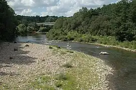 The Nive at Itxassou
 Saint-Jean-Pied-de-Port (the Nive de Béhérobie)
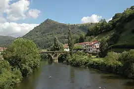 Bidarray, the bridge Noblia over the Nive
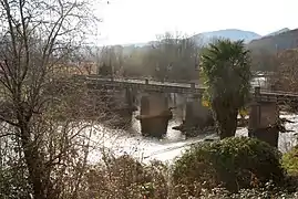 Ustaritz, bridge over the Nive
Related pages
References
- "La Nive (Q9--0250)" (in French). SANDRE - Portail national d'accès aux référentiels sur l'eau. Retrieved 31 March 2014.
- "La Nive à Cambo-les-Bains" (in French). Banque Hydro. Archived from the original on 3 March 2016. Retrieved 8 June 2017.
- "Le Laurhibar (Q9030500)" (in French). SANDRE - Portail national d'accès aux référentiels sur l'eau. Archived from the original on 4 March 2016. Retrieved 31 March 2014.
- "La Nive d'Arnéguy (Q90-0400)" (in French). SANDRE - Portail national d'accès aux référentiels sur l'eau. Archived from the original on 5 March 2016. Retrieved 31 March 2014.
- "La Nive des Aldudes (Q91-0400)" (in French). SANDRE - Portail national d'accès aux référentiels sur l'eau. Archived from the original on 4 March 2016. Retrieved 31 March 2014.
- "Le Bastan (Q92-0430)" (in French). SANDRE - Portail national d'accès aux référentiels sur l'eau. Archived from the original on 5 March 2016. Retrieved 31 March 2014.
- "Lakako Erreka (Q92-0400)" (in French). SANDRE - Portail national d'accès aux référentiels sur l'eau. Archived from the original on 5 March 2016. Retrieved 31 March 2014.
Other websites
- Tour de la Haute vallée de la Nive (in French)
- Contrat de Rivière des Nives Archived 2011-02-01 at the Wayback Machine (in French)