Montreuil, Seine-Saint-Denis
Montreuil is a town in the east suburbs of Paris, France. Montreuil is near the Bois de Vincennes park in the Île-de-France region and the Seine-Saint-Denis department. About 91,000 people lived there in 1999. It is the third most populated suburb of Paris (after Boulogne-Billancourt and Argenteuil).
Montreuil | |
|---|---|
.svg.png.webp) Coat of arms | |
 Paris and inner ring departments | |
Location of Montreuil | |
 Montreuil 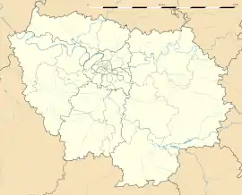 Montreuil | |
| Coordinates: 48°51′40″N 2°26′37″E | |
| Country | France |
| Region | Île-de-France |
| Department | Seine-Saint-Denis |
| Arrondissement | Bobigny |
| Canton | Montreuil-1 and 2 |
| Intercommunality | Grand Paris |
| Government | |
| • Mayor (2020–2026) | Patrice Bessac[1] (PCF) |
| Area 1 | 8.92 km2 (3.44 sq mi) |
| Population | 111,240 |
| • Density | 12,000/km2 (32,000/sq mi) |
| Time zone | UTC+01:00 (CET) |
| • Summer (DST) | UTC+02:00 (CEST) |
| INSEE/Postal code | 93048 /93100 |
| Elevation | 52–117 m (171–384 ft) (avg. 70 m or 230 ft) |
| 1 French Land Register data, which excludes lakes, ponds, glaciers > 1 km2 (0.386 sq mi or 247 acres) and river estuaries. | |
References
- "Répertoire national des élus: les maires". data.gouv.fr, Plateforme ouverte des données publiques françaises (in French). 2 December 2020. Retrieved 7 December 2020.
- "Populations légales 2019". The National Institute of Statistics and Economic Studies. 29 December 2021.
Other websites
Wikimedia Commons has media related to Montreuil (Seine-Saint-Denis).
- Official website (in French)
This article is issued from Wikipedia. The text is licensed under Creative Commons - Attribution - Sharealike. Additional terms may apply for the media files.