M6 motorway
The M6 is the longest motorway in the United Kingdom. It is also one of the busiest motorways in the country.[1] It is often referred to as "The Backbone of Britain". The M6 is part of the unsigned E-road E24 from the M1 to the M6 Toll near Birmingham. The E5 joins the M6 Toll from the M42 and then uses the M6 to its north end at Carlisle. Then it continues to become the M74. The motorway is 230 miles (370km) long. This is 37 miles longer than the M1 motorway.
_map.svg.png.webp)
History and curiosities

The first section of the motorway was the Preston by-pass, opened on 5 December 1958. It was built by a company called Tarmac Construction. It was the first motorway in the United Kingdom. It was opened by Prime Minister Harold Macmillan. The motorway was later extended in both directions.
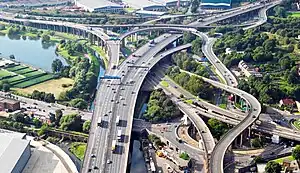
Junction 6 in Birmingham has the name Spaghetti Junction. This is because it looks very complex from the sky.
On the high ground between Shap and Tebay, the north and south-bound carriages split apart. Strangely, at this point a local road runs between the two carriageways without a link to the motorway.
The section of the M6 which runs over Shap Fell in Cumbria is 1050 ft (320 m) above sea level. This is one of the highest points on any motorway in the UK. The West Coast Main Line railway follows the same course. It runs alongside the M6 for much of its length.
Route
The motorway starts at the M1 in Rugby. It passes through Birmingham and Spaghetti Junction. The motorway continues to the north, passing Liverpool and Manchester. It goes around Preston and up to Lancaster. It then follows through a valley past the Lake District and Penrith. It finishes at Carlisle.
Cumberland Gap

At the end of the M6 motorway at Carlisle, there is a 6-mile stretch of the A74 which links England to Scotland. This is called the Cumberland Gap. This was caused by an argument between the British Parliament and the Scottish Parliament, which left neither the M6 or the A74(M) being built. After a lot of controversy, building started on the remaining six miles. When it is completed, there will be a complete motorway going from London to Glasgow.[2]
M6 Toll
The M6 Toll is a toll road which was opened in 2003. It starts at Junction 11A and runs around Birmingham to Junction 3A. It is the first toll road to be built in the United Kingdom. It was opened on 9 December 2003. It is reported to save 45 minutes from the average journey.[3]
Junctions
| M6 motorway junctions | |||||
| mile | km | Northbound exits (A carriageway) | Junction | Southbound exits (B carriageway) | Coordinates |
| Motorway continues as A74(M) on Scottish Border before becoming M74 and then joining M8 and M77) in Glasgow, Scotland | Start of motorway | 54.996672°N 3.055336°W | |||
| 313.2 | 504.3 | Gretna B7076, Longtown A6071 | J45 |
No access (on-slip only) | 54.992979°N 3.048234°W |
| River Esk | 54.974768°N 3.009213°W | ||||
| 309.6 309.2 |
498.2 497.5 |
Todhills Rest Area | Services | Todhills Rest Area | 54.951585°N 2.979612°W |
| 307.6 307.3 |
495.1 494.6 |
Carlisle (North), Galashiels A7 | J44 |
Carlisle A7, Workington A689 | 54.930138°N 2.946332°W |
| River Eden | 54.909346°N 2.895290°W | ||||
| 303.8 303.5 |
488.9 488.4 |
Carlisle, Hexham, Newcastle A69 | J43 | Carlisle, Hexham, Newcastle A69 | 54.895293°N 2.886851°W |
| 301.1 300.7 |
484.6 484.0 |
Carlisle (South) A6 | J42 | Carlisle A6 | 54.85759°N 2.878375°W |
| Southwaite services | Services | Southwaite services | 54.799077°N 2.871079°W | ||
| 288.7 288.4 |
464.6 464.1 |
Wigton B5305 | J41 | Wigton B5305 | 54.69343°N 2.791729°W |
| 285.5 285.2 |
459.5 459.0 |
Penrith, Workington, Brough A66 | J40 | Penrith, Keswick, Brough A66 | 54.653056°N 2.760186°W |
| 274.4 274.0 |
441.6 441.0 |
Shap (A6) | J39 | Shap, Kendal (A6) | 54.508252°N 2.649765°W |
| Tebay services | Services | Tebay services | 54.451304°N 2.608008°W | ||
| River Lune | 54.44115°N 2.59518°W | ||||
| 268.9 268.5 |
432.7 432.1 |
Brough A685, Appleby B6260 | J38 | Kendal, Brough A685 | 54.436805°N 2.596893°W |
| 260.3 260.0 |
418.9 418.4 |
Kendal, Sedbergh A684 | J37 | Kendal, Sedbergh A684 | 54.330965°N 2.622857°W |
| No access | Services | Killington Lake services | 54.315046°N 2.639122°W | ||
| 252.7 252.3 |
406.7 406.0 |
Barrow, Kendal A590 (A591), Kirkby Lonsdale A65 | J36 | Skipton, Kirkby Lonsdale A65, Barrow A590 | 54.236365°N 2.716541°W |
| Burton-in-Kendal services | Services | No access | 54.178185°N 2.733879°W | ||
| Entering Cumbria | Entering Lancashire | 54.17005°N 2.73748°W | |||
| 245.1 244.6 |
394.4 393.6 |
Carnforth, Morecambe A601(M) (A6) | J35 | Carnforth, Morecambe A601(M) (A6) | 54.128700°N 2.749758°W |
| 240.8 240.6 |
387.6 387.2 |
Kirkby Lonsdale, Heysham, Morecambe, Heysham |
J34 | Lancaster, Morecambe, Heysham A683 | 54.071578°N 2.771087°W |
| 234.6 234.3 |
377.6 377.1 |
Lancaster (South) A6 | J33 | Garstang, Fleetwood A6 | 53.982516°N 2.780743°W |
| Lancaster (Forton) services | Services | Lancaster (Forton) services | 53.962095°N 2.760229°W | ||
| River Wyre | 53.95391°N 2.75135°W | ||||
| 221.5 221.0 |
356.5 355.7 |
Blackpool, Fleetwood M55 Preston (N) (A6) |
J32 | Blackpool, Preston (N) (A6) M55 | 53.806759°N 2.697787°W |
| 219.5 219.3 |
353.2 352.9 |
Preston (E), Longridge B6242 | J31A | No access (on-slip only) | 53.788940°N 2.658262°W |
| River Ribble | J31 | Preston, Clitheroe A59 | 53.764949°N 2.635903°W | ||
| Preston (C), Blackburn (N), Clitheroe A59 | River Ribble | ||||
| 215.4 214.9 |
346.6 345.9 |
No access (on-slip only) | J30 | Manchester, Bolton M61, Leeds (M62), Blackburn (M65) | 53.734320°N 2.647705°W |
| 213.9 213.5 |
344.3 343.6 |
Burnley, Blackburn, Preston (S) M65 | J29 | Burnley, Blackburn M65 | 53.716190°N 2.660751°W |
| 212.3 211.9 |
341.6 341.0 |
Leyland B5256 (A49) | J28 | Leyland B5256 | 53.695893°N 2.677574°W |
| Charnock Richard services | Services | Charnock Richard services | 53.631534°N 2.690835°W | ||
| 204.8 | 329.6 | Entering Lancashire | J27 | Wigan, Parbold A5209 | 53.589728°N 2.694440°W |
| 204.4 | 329.0 | Parbold, Standish, Chorley A5209 | Entering Greater Manchester | ||
| Gathurst Viaduct | 53.5617°N 2.7009°W | ||||
| 200.8 200.5 |
323.1 322.6 |
Skelmersdale, Liverpool, Southport M58 | J26 | Skelmersdale, Liverpool, Southport M58 | 53.534110°N 2.698045°W |
| 198.0 197.8 |
318.7 318.3 |
Wigan A49 | J25 | No access (on-slip only) | 53.501806°N 2.659678°W |
| 196.9 196.5 |
316.9 316.3 |
No access (on-slip only) | J24 | St Helens, Ashton A58 | 53.486718°N 2.652898°W |
| Entering Greater Manchester | Entering Merseyside | 53.4802°N 2.64398°W | |||
| 195.6 195.2 |
314.8 314.1 |
St Helens, Liverpool, Southport A580 | J23 | Manchester, Liverpool, Newton A580 | 53.471292°N 2.633629°W |
| 192.4 | 309.6 | Entering Merseyside | J22 | Warrington (North) A49 | 53.440116°N 2.584105°W |
| 192.1 | 309.1 | Newton A49, Leigh A579 | Entering Cheshire | ||
| 191.0 190.5 |
307.4 306.5 |
Leeds, Bolton, Manchester (N) M62 | J21A | Manchester, Bolton, Leeds M62 | 53.425926°N 2.555909°W |
| Liverpool, Warrington (N), Southport (M57) M62 | Liverpool M62 | ||||
| 188.3 188.0 |
303.0 302.5 |
Warrington (Ctr & East), Irlam A57 | J21 | Warrington (Central), Irlam A57 | 53.397814°N 2.509947°W |
| Thelwall Viaduct | 53.389753°N 2.505784°W | ||||
| 185.6 | 298.7 | NORTH WALES, Chester, Runcorn M56 Warrington (South), Lymm A50 Lymm Truck Stop |
J20 Services |
Macclesfield, Warrington (S) A50, Lymm B5158 Lymm Truck Stop |
53.360413°N 2.509089°W |
| 185.3 184.5 |
298.2 296.9 |
NORTH WALES, Chester, Runcorn, Manchester (S & |
53.358466°N 2.507973°W | ||
| End of variable speed limit |
J19 | Start of variable speed limit |
53.311596°N 2.417636°W | ||
| 180.3 179.9 |
290.2 289.5 |
Manchester, Manchester |
Northwich, Macclesfield, Knutsford A556 | ||
| Knutsford services | Services[Note 2] | Knutsford services | 53.300826°N 2.401586°W | ||
| 172.2 171.9 |
277.2 276.7 |
Chester, Northwich, Middlewich A54 | J18 | Chester, Northwich, Middlewich A54 | 53.200377°N 2.387509°W |
| 168.9 168.3 |
271.3 270.8 |
Congleton, Sandbach A534 | J17 | Congleton, Sandbach A534 | 53.153230°N 2.346697°W |
| Sandbach services | Services | Sandbach services | 53.139048°N 2.336526°W | ||
| 162.6 | 261.7 | Entering Cheshire | J16 | Newcastle-under-Lyme, Stoke-on-Trent (North), Crewe, Nantwich A500 | 53.068632°N 2.333565°W |
| Start of variable speed limit |
End of variable speed limit | ||||
| 162.3 | 261.2 | Nantwich, Crewe A500 | Entering Staffordshire | ||
| Keele services | Services | Keele services | 52.993555°N 2.289362°W | ||
| 153.1 152.9 |
246.4 246.1 |
Stoke-on-Trent, Newcastle-under-Lyme A500 | J15 | Stoke-on-Trent, Stone A500, Derby (A50) | 52.975573°N 2.226319°W |
| Stafford services (northbound) | Services | No access | 52.883919°N 2.168555°W | ||
| No access | Stafford services (southbound) | 52.873948°N 2.164907°W | |||
| 142.0 141.8 |
228.6 228.2 |
Stone, Stafford (N) A34 | J14 | Stafford (N) A34 | 52.826520°N 2.145596°W |
| End of variable speed limit |
J13 | Start of variable speed limit |
52.763567°N 2.107873°W | ||
| 136.8 136.5 |
220.1 219.6 |
Stafford (S & C) A449 | Stafford (S) A449 | ||
| 131.6 131.2 |
211.8 211.1 |
Telford (M54) A5 | J12 | NORTH WALES, Telford (M54), Wolverhampton, Cannock A5 | 52.689026°N 2.103453°W |
| No access (on-slip only) | J11A (TOTSO SB) |
The SOUTH M6 Toll | 52.669538°N 2.074270°W | ||
| 128.7 128.4 |
207.2 206.7 |
(M6 Toll), Cannock A460 | J11 | Wolverhampton, Cannock A460 | 52.658424°N 2.06440°W |
| Hilton Park services | Services | Hilton Park services | 52.643402°N 2.056503°W | ||
| 127.0 126.7 |
204.4 203.9 |
NORTH & MID WALES, Telford, Wolverhampton, Shrewsbury (A5) M54 | J10A | No access (on-slip only) | 52.630172°N 2.048950°W |
| Entering West Midlands | 52.61874°N 2.03209°W | ||||
| Entering Staffordshire | 52.61693°N 2.03038°W | ||||
| 123.3 122.9 |
198.4 197.8 |
Walsall, Wolverhampton (C & E) A454 | J10 | Wolverhampton (C & E), Walsall A454 | 52.584877°N 2.014275°W |
| 121.7 121.5 |
195.8 195.6 |
Wednesbury A461 | J9 | Wednesbury A461 | 52.566543°N 2.003202°W |
| 119.9 | 193.0 | The SOUTH WEST, Birmingham (W & S), West Bromwich M5 | J8 |
The SOUTH WEST, Birmingham (W & S), West Bromwich M5 | 52.557125°N 1.976681°W |
| 118.4 118.1 |
190.6 190.1 |
Birmingham (N), Walsall A34 | J7 |
Birmingham (N) A34 | 52.553081°N 1.934023°W |
| 114.2 113.9 |
183.8 183.3 |
Birmingham (C) A38(M) Birmingham (NE) A38 |
J6 |
Birmingham (NE), Lichfield A38 Birmingham (E & C) A38(M) |
52.510083°N 1.863792°W |
| Bromford Viaduct | 52.506°N 1.829°W | ||||
| 110.9 110.8 |
178.5 178.3 |
Birmingham (E), Sutton Coldfield A452 | J5 |
No access (on-slip only) | 52.509274°N 1.789076°W |
| Entering Warwickshire | 52.51302°N 1.75356°W | ||||
| 108.8 108.6 |
175.1 174.8 |
No access (on-slip only) | J4A | The NORTH EAST (M1), The NORTH WEST (M6 Toll), Tamworth M42(N) The SOUTH WEST (M5), London (S & W) (M40), Birmingham (S), Birmingham International |
52.509966°N 1.747062°W |
| Entering West Midlands | 52.47857°N 1.71495°W | ||||
| 106.0 | 170.6 | Start of variable speed limit |
J4 | Coventry (S & W), Birmingham (E), N.E.C., Birmingham International |
52.476808°N 1.707237°W |
| 105.7 | 170.1 | Coleshill A446 The SOUTH WEST (M5), Birmingham (S), Solihull, N.E.C., Birmingham |
End of variable speed limit | ||
| The NORTH WEST M6 Toll, Tamworth M42(N) | J3A (TOTSO NB) |
No access (on-slip only) | 52.473880°N 1.671681°W | ||
| Corley services | Services | Corley services | 52.471488°N 1.546326°W | ||
| 96.9 96.4 |
155.9 155.2 |
Coventry (North), Nuneaton, Bedworth A444 | J3 | Coventry (N), Nuneaton A444, Bedworth B4113 | 52.463004°N 1.493776°W |
| Entering Warwickshire | Entering West Midlands | 52.45798°N 1.48271°W | |||
| Entering West Midlands | Entering Warwickshire | 52.43995°N 1.43995°W | |||
| 93.7 93.3 |
150.8 150.1 |
Coventry, Warwick A46 Leicester, Hinckley M69 |
J2 | (M1(N)), Leicester M69, Coventry (E) A46 | 52.437870°N 1.429832°W |
| 85.6 85.2 |
137.8 137.1 |
Rugby A426 | J1 | Rugby, Lutterworth A426 | 52.408087°N 1.245725°W |
| Entering Warwickshire | Entering Leicestershire | 52.40604°N 1.2096°W | |||
| 85.2 | 137.1 | Start of motorway |
M1 J19 |
The SOUTH, London, Northampton M1 | 52.400442°N 1.175215°W |
| The NORTH, Leicester M1(N) | End of motorway Road continues as A14 before becoming M11 and then joining A406 in South Woodford, Greater London | ||||
- Notes
Other websites
| England, Scotland and Wales | |||||||||
|---|---|---|---|---|---|---|---|---|---|
| Northern Ireland | |||||||||
| former |
A40(M) • A41(M) • A102(M) • A6144(M) | ||||||||