Lower Hutt
Lower Hutt (Māori: Te Awa Kairangi ki Tai) is a city in the Wellington Region of New Zealand. It is the sixth most populous city in New Zealand.
Lower Hutt
| |
|---|---|
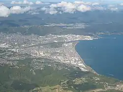 Lower Hutt from the air, looking eastwards in March 2009 | |
 Coat of arms | |
 | |
| Coordinates: 41°13′S 174°55′E | |
| Country | |
| Region | Wellington |
| Wards |
|
| Community Boards |
|
| Electorates | Hutt South (general) Remutaka (general) Te Tai Tonga (Māori) Ikaroa-Rāwhiti (Māori) |
| Suburbs | List |
| Government | |
| • Mayor | Campbell Barry (Labour) |
| • Deputy Mayor | Tui Lewis |
| • MPs | Ginny Andersen (Labour) Chris Hipkins (Labour) Rino Tirikatene (Labour) Meka Whaitiri (Labour) |
| • Territorial authority | Hutt City Council |
| Area | |
| • Territorial | 376.40 km2 (145.33 sq mi) |
| • Urban | 78.53 km2 (30.32 sq mi) |
| • Rural | 297.87 km2 (115.01 sq mi) |
| Population (June 2022)[2] | |
| • Territorial | 112,500 |
| • Density | 300/km2 (770/sq mi) |
| • Urban | 111,500 |
| • Urban density | 1,400/km2 (3,700/sq mi) |
| Postcode(s) | 5010, 5011, 5012, 5013, 5014, 5019 |
| Area code | 04 |
| Website | www |
References
- "Poari Hapori Community Boards". Hutt City Council. Retrieved 5 February 2022.
- "Subnational population estimates (RC, SA2), by age and sex, at 30 June 1996-2022 (2022 boundaries)". Statistics New Zealand. Retrieved 25 October 2022. (regional councils); "Subnational population estimates (TA, SA2), by age and sex, at 30 June 1996-2022 (2022 boundaries)". Statistics New Zealand. Retrieved 25 October 2022. (territorial authorities); "Subnational population estimates (urban rural), by age and sex, at 30 June 1996-2022 (2022 boundaries)". Statistics New Zealand. Retrieved 25 October 2022. (urban areas)
This article is issued from Wikipedia. The text is licensed under Creative Commons - Attribution - Sharealike. Additional terms may apply for the media files.