Low Mountain, Arizona
Low Mountain is a census-designated place (CDP) in Navajo County, Arizona, United States. The population was 631 at the 2020 census.[3]
Low Mountain, Arizona | |
|---|---|
 Low Mountain Location within the state of Arizona  Low Mountain Low Mountain (the United States) | |
| Coordinates: 35°56′53″N 110°05′53″W | |
| Country | United States |
| State | Arizona |
| County | Navajo |
| Area | |
| • Total | 36.90 sq mi (95.58 km2) |
| • Land | 36.90 sq mi (95.56 km2) |
| • Water | 0.01 sq mi (0.02 km2) |
| Elevation | 1,880 ft (570 m) |
| Population | |
| • Total | 631 |
| • Density | 17.10/sq mi (6.60/km2) |
| Time zone | UTC-7 (MST) |
| Area code | 928 |
| FIPS code | 04-42590 |
| GNIS feature ID | 2582817 |
References
- "2020 U.S. Gazetteer Files". United States Census Bureau. Retrieved October 29, 2021.
- "Feature Detail Report for: Low Mountain Census Designated Place". Geographic Names Information System. United States Geological Survey.
- "Low Mountain CDP, Arizona". United States Census Bureau. Retrieved September 8, 2023.
| Cities | 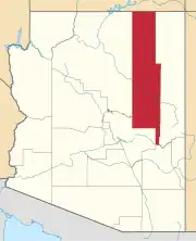 | |
|---|---|---|
| Towns | ||
| CDPs |
| |
| Populated places |
| |
| Indian reservations |
| |
| Ghost towns |
| |
| Footnotes | ‡This populated place also has portions in an adjacent county or counties | |
This article is issued from Wikipedia. The text is licensed under Creative Commons - Attribution - Sharealike. Additional terms may apply for the media files.