Krumbach, Bavaria
Krumbach, Bavaria or Krumbach (Swabia), (Swabian: Krombach) is a town with about 12.500 persons in Günzburg (district) in the Bavarian government region Swabia (Government Region), Germany. In Günzburg (district) only Günzburg with about 19.689 persons has more persons than Krumbach.
Krumbach, Bavaria | |
|---|---|
 Coat of arms | |
Location of Krumbach, Bavaria | |
 Krumbach, Bavaria  Krumbach, Bavaria | |
| Coordinates: 48°15′N 10°22′E | |
| Country | Germany |
| State | Bavaria |
| Admin. region | Swabia |
| District | Günzburg |
| Government | |
| • Mayor | Hubert Fischer |
| Area | |
| • Total | 44.75 km2 (17.28 sq mi) |
| Elevation | 512 m (1,680 ft) |
| Population (2022-12-31)[1] | |
| • Total | 13,807 |
| • Density | 310/km2 (800/sq mi) |
| Time zone | UTC+01:00 (CET) |
| • Summer (DST) | UTC+02:00 (CEST) |
| Postal codes | 86381 |
| Dialling codes | 08282 |
| Vehicle registration | GZ |
| Website | www.krumbach.de |

Geography / Nature
Krumbach (Elevation 512 m (1680 ft)) is in the valley of the little river Kammel in the natural region Lower Iller-Lech Gravel Plateau . The hills between the valleys of Kammel and the neighboring valleys of Günz and Mindel are covered with wood in parts. Cities near Krumbach are Ulm (40 kilometres northwest from Krumbach), Augsburg (48 kilometres east from Krumbach) and Munich (120 kilometres east from Krumbach).Towns near Krumbach are Günzburg (27 kilometres north from Krumbach), Mindelheim (30 kilometres south from Krumbach) and Memmingen (40 kilometres southwest from Krumbach).
Krumbach has a station at the Mittelschwaben Railway and it is at two Bundesstraßen (short: “B“): B16 and B300;
History
1156: Krumbach was founded
1370: the village got the right to hold a market
1305-1805: Krumbach was part of the Margraviate of Burgau, a part of Austria (the colours of the coat of arms (red and white) show the colours of Austria until today)
1805: Krumbach became Bavarian
1895: Krumbach became a town
1902: the neighboring village Hürben, a village with many Jewish persons became part of the town Krumbach
until 1972: Krumbach was the capital of Krumbach, Swabia (district)
The villages Attenhausen, Edenhausen, Billenhausen, Hirschfelden, Hohenraunau and Niederraunau became in the years between 1972 and 1978 part of the municipality Krumbach.
Sights and attractions
- market place and historic town hall
- church St Michael
- church St Ulrich in Hürben
- church Maria Hilf
- church Lindlkirche
- Mühlkapelle
- castle of Krumbach
- moated castle of Hürben
- Landauer Haus
- Middleswabian local heritage museum
- waxart museum
- Krumbad
- church of Niederraunau
- castle of Niederraunau
- Dossenberger Pfarrhof (parsonage) Billenhausen
 church St Michael
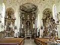 church St Michael
 church St Michael
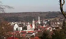
 Church St Michael and Castle of Krumbach from the municipal park
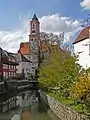
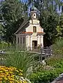 Mühlkapelle at the Kammel
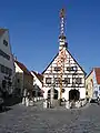 market place and historic town hall
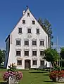 moated castle of Hürben
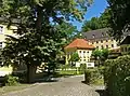 Krumbad
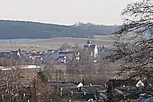
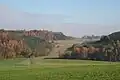 nature near Krumbach
Miscellaneous
- The Krumbad is a health resort one kilometre east of Krumbach. It is the oldest health resort of Swabia.
- In the valley of Günz – six kilometres west of Krumbach there is the Oberrieder Weiher, a flooded gravel pit, which is today a greenbelt recreation area.
References
- Genesis Online-Datenbank des Bayerischen Landesamtes für Statistik Tabelle 12411-003r Fortschreibung des Bevölkerungsstandes: Gemeinden, Stichtag (Einwohnerzahlen auf Grundlage des Zensus 2011) .
Quarters of Krumbach (Schwaben) | ||
|---|---|---|
Krumbach | Hürben | Krumbad | Attenhausen | Billenhausen | Edenhausen | Hirschfelden | Hohenraunau | Niederraunau | ||