Interstate 68
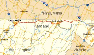
Interstate 68 is an Interstate Highway in the United States. It goes from Morgantown, West Virginia east to Hancock, Maryland. The route is 112.9 miles (181.7 km) long.[1][2][3][4]
Interstate 68 | |||||||
|---|---|---|---|---|---|---|---|
 | |||||||
| Route information | |||||||
| Maintained by WVDOH and MDSHA | |||||||
| Length | 112.9 mi[1][2][3][4] (181.7 km) | ||||||
| Existed | 1991–present | ||||||
| NHS | Entire route | ||||||
| Major junctions | |||||||
| West end | |||||||
| |||||||
| East end | |||||||
| Location | |||||||
| Country | United States | ||||||
| Highway system | |||||||
| |||||||

References
- Carol Melling (2003-10-31). "I-68 Extension Now Eligible for Federal Funding". West Virginia Department of Transportation. Archived from the original on 2009-05-23. Retrieved 2009-01-17.
- "Highway Location Reference: Garrett County" (PDF). Maryland State Highway Administration. 2009. Retrieved 2010-10-21.
- "Highway Location Reference: Allegany County" (PDF). Maryland State Highway Administration. 2009. Retrieved 2010-10-21.
- "Highway Location Reference: Washington County" (PDF). Maryland State Highway Administration. 2009. Retrieved 2010-10-21.
| Signed | |
|---|---|
| Unsigned | |
| Lists | |
Major Interstates highlighted | |
This article is issued from Wikipedia. The text is licensed under Creative Commons - Attribution - Sharealike. Additional terms may apply for the media files.