Hohenpeißenberg
Hohenpeißenberg is a municipality in Weilheim-Schongau in Bavaria, Germany. Hohenpeißenberg is in the Bavarian Oberland, in the alpine uplan.
Hohenpeißenberg | |
|---|---|
 Pilgrimage Church of the Assumption of the Virgin Mary in winter | |
 Coat of arms | |
Location of Hohenpeißenberg within Weilheim-Schongau district 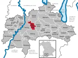 | |
 Hohenpeißenberg  Hohenpeißenberg | |
| Coordinates: 47°48′N 11°0′E | |
| Country | Germany |
| State | Bavaria |
| Admin. region | Upper Bavaria |
| District | Weilheim-Schongau |
| Government | |
| • Mayor (2020–26) | Thomas Dorsch[1] (CSU) |
| Area | |
| • Total | 20.44 km2 (7.89 sq mi) |
| Elevation | 780 m (2,560 ft) |
| Population (2022-12-31)[2] | |
| • Total | 3,872 |
| • Density | 190/km2 (490/sq mi) |
| Time zone | UTC+01:00 (CET) |
| • Summer (DST) | UTC+02:00 (CEST) |
| Postal codes | 82383 |
| Dialling codes | 08805 |
| Vehicle registration | WM |
| Website | www |
It exists only as a local subdistrict.
Geography
The highest point is the peak of the 988 meter high Hoher Peißenberg (high Peißenberg).
The region is on the left edge of the Ammer. The Ammer flows south of the local center in a small ravine called the "Schnalz".
References
- Liste der ersten Bürgermeister/Oberbürgermeister in kreisangehörigen Gemeinden, Bayerisches Landesamt für Statistik, 15 July 2021.
- Genesis Online-Datenbank des Bayerischen Landesamtes für Statistik Tabelle 12411-003r Fortschreibung des Bevölkerungsstandes: Gemeinden, Stichtag (Einwohnerzahlen auf Grundlage des Zensus 2011) .
Wikimedia Commons has media related to Hohenpeißenberg.
This article is issued from Wikipedia. The text is licensed under Creative Commons - Attribution - Sharealike. Additional terms may apply for the media files.