Höchstadt
Höchstadt an der Aisch, commonly known as Höchstadt (German pronunciation: [ˈhøːçˌʃtat] (![]() listen)), is a town in the Erlangen-Höchstadt district, in Bavaria, Germany.
listen)), is a town in the Erlangen-Höchstadt district, in Bavaria, Germany.
Höchstadt | |
|---|---|
 Town tower | |
 Coat of arms | |
Location of Höchstadt within Erlangen-Höchstadt district 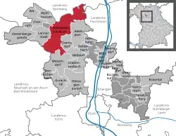 | |
 Höchstadt  Höchstadt | |
| Coordinates: 49°42′N 10°48′E | |
| Country | Germany |
| State | Bavaria |
| Admin. region | Middle Franconia |
| District | Erlangen-Höchstadt |
| Subdivisions | 23 districts |
| Government | |
| • Mayor (2020–26) | Gerald Brehm[1] |
| Area | |
| • Total | 70.90 km2 (27.37 sq mi) |
| Elevation | 273 m (896 ft) |
| Population (2022-12-31)[2] | |
| • Total | 13,931 |
| • Density | 200/km2 (510/sq mi) |
| Time zone | UTC+01:00 (CET) |
| • Summer (DST) | UTC+02:00 (CEST) |
| Postal codes | 91315 |
| Dialling codes | 09193 |
| Vehicle registration | ERH, HÖS |
| Website | www.hoechstadt.de |
Geography
Höchstadt is on the river Aisch, 18 km northwest of Erlangen and 22 km south of Bamberg. Originally it was the capital of the Höchstadt district, but then it became part of the new Erlangen-Höchstadt district.
Division of the town
The town consists of 23 districts:
|
|
|
Other websites
- Official website
 (in German)
 - Webcam of a storks' nest
References
- Liste der ersten Bürgermeister/Oberbürgermeister in kreisangehörigen Gemeinden, Bayerisches Landesamt für Statistik, 15 July 2021.
- Genesis Online-Datenbank des Bayerischen Landesamtes für Statistik Tabelle 12411-003r Fortschreibung des Bevölkerungsstandes: Gemeinden, Stichtag (Einwohnerzahlen auf Grundlage des Zensus 2011) .
Towns and municipalities in Erlangen-Höchstadt | ||
|---|---|---|
Coat of Arms of Erlangen-Höchstadt district | ||
This article is issued from Wikipedia. The text is licensed under Creative Commons - Attribution - Sharealike. Additional terms may apply for the media files.