Fulda (district)
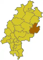
Fulda (IPA: [ˈfʊlda]) is a Kreis (district) in the north-east of Hesse, Germany.
Fulda | |
|---|---|
 Flag  Coat of arms | |
 | |
| Coordinates: 50°30′N 9°40′E | |
| Country | Germany |
| State | Hesse |
| Capital | Fulda |
| Area | |
| • Total | 1,380.39 km2 (532.97 sq mi) |
| Population (31 December 2022)[1] | |
| • Total | 227,456 |
| • Density | 160/km2 (430/sq mi) |
| Time zone | UTC+01:00 (CET) |
| • Summer (DST) | UTC+02:00 (CEST) |
| Vehicle registration | FD |
| Website | http://www.landkreis-fulda.de |
History
The district was created in 1821, when the duchy of Stift Fulda became a province of Hesse, and was split into four districts. The last change to the district was in 1975, when the Hünfeld district was added to the district.
Stiffoller
Arround 1717-1804, People from Stift Fulda went to Hungary, and settled especially in the Komitat Baranya. This subgroup of the Danube Swabians are called Stiffoller,[2] There is also a street named the Stiffollerweg in Petersberg near Fulda[3]
Coat of arms
 |
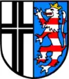
The left side of the coat of arms shows a black cross, the sign of the monastery of Fulda. The lion on the right side is taken from the Hesse coat of arms, symbolizing that the district was part of Hesse 1821–1866, and again after 1945. The coat of arms was granted in 1936. |
Towns and municipalities
| Towns | Municipalities | |
|---|---|---|
|
|
|
References
- "Bevölkerung in Hessen am 31.12.2022 nach Gemeinden" (XLS) (in German). Hessisches Statistisches Landesamt. June 2023.
- https://www.worldcat.org/oclc/311888384
- https://www.meinestadt.de/petersberg-fulda/stadtplan/strasse/stiffollerweg
Other websites
This article is issued from Wikipedia. The text is licensed under Creative Commons - Attribution - Sharealike. Additional terms may apply for the media files.