Fire Island, New York
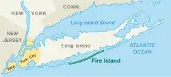
Fire Island is a barrier island, approximately 31 miles (49.5 km) long and varying between approximately 0.1 mile (0.16 km) to 0.5 mile (0.8 km) wide, in Suffolk County on the southern side of Long Island in the U.S. state of New York, running approximately WSW to ENE. The land area is 48 km² (18.7 sq mi) and a permanent population of 310 persons was reported as of the 2000 census. (There are many thousands of seasonal residents.)
Fire Island, New York | |
|---|---|
 Fire Island | |
| Coordinates: 40°39′11″N 73°7′33″W | |
| Country | United States |
| State | New York |
| County | Suffolk |
| Area | |
| • Total | 8.7 sq mi (22.4 km2) |
| • Land | 8.7 sq mi (22.4 km2) |
| • Water | 0.0 sq mi (0.0 km2) |
| Elevation | 3 ft (1 m) |
| Population (2000) | |
| • Total | 310 |
| • Density | 35.8/sq mi (13.8/km2) |
| Time zone | UTC-5 (Eastern (EST)) |
| • Summer (DST) | UTC-4 (EDT) |
| ZIP code | 11770 |
| Area code | 631 |
| FIPS code | 36-25839 |
| GNIS feature ID | 1852899 |
The Cherry Grove and Fire Island Pines hamlets of Fire Island have been known as a popular gay village.[1]
References
- "Fire Island: A gay paradise of sex and liberation". BBC. Retrieved July 23, 2023.
Other websites
Wikimedia Commons has media related to Fire Island.
Wikivoyage has a travel guide about: Fire Island
Municipalities and communities of Suffolk County, New York, United States | ||
|---|---|---|
| Towns |  | |
| Villages |
| |
| CDPs |
| |
| Hamlets |
| |
| Reservations |
| |
This article is issued from Wikipedia. The text is licensed under Creative Commons - Attribution - Sharealike. Additional terms may apply for the media files.