Dunsandel
Dunsandel is a small town in the South Island, New Zealand. It is in the Selwyn District, New Zealand. It is half-way between Christchurch and Ashburton. It has roads connecting to Hororata, Leeston and Southbridge. It has a primary school, eateries and small shops in the township on State Highway 1.
Dunsandel | |
|---|---|
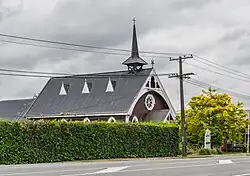 Dunsandel Methodist Church | |
| Coordinates: 43°39′38″S 172°11′34″E | |
| Country | |
| Region | Canterbury region |
| District | Selwyn District |
| Ward | Ellesmere |
| Area | |
| • Total | 1.94 km2 (0.75 sq mi) |
| Population (2018 Census)[2] | |
| • Total | 438 |
| • Density | 230/km2 (580/sq mi) |
References
- "ArcGIS Web Application". statsnz.maps.arcgis.com. Retrieved 18 October 2021.
- "Statistical area 1 dataset for 2018 Census". Statistics New Zealand. March 2020. 7026739 (7026739) and 7026741 (7026741).
This article is issued from Wikipedia. The text is licensed under Creative Commons - Attribution - Sharealike. Additional terms may apply for the media files.