Domodedovo (town)
Domodedovo (Russian: Домодедово) is a city in Moscow Oblast of Russia. As of 2010, the city has 96,145 people. The city surrounds Domodedovo Airport, one of the international airports of Moscow, the capital and largest city of Russia.
Domodedovo
Домодедово | |
|---|---|
Town | |
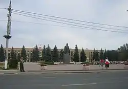
 Monument to Vladimir Lenin in Domodedovo | |
 Flag .png.webp) Coat of arms | |
Location of Domodedovo | |
 Domodedovo Location of Domodedovo  Domodedovo Domodedovo (Moscow Oblast) | |
| Coordinates: 55°26′24″N 37°45′43″E | |
| Country | Russia |
| Federal subject | Moscow Oblast |
| Founded | 1900 |
| Town status since | 1947 |
| Government | |
| • Body | Council of Deputies[1] |
| Area | |
| • Total | 159.27 km2 (61.49 sq mi) |
| Elevation | 160 m (520 ft) |
| Population | |
| • Total | 96,145 |
| • Rank | 177th in 2010 |
| • Density | 600/km2 (1,600/sq mi) |
Administrative status | |
| • Subordinated to | Domodedovo Town Under Oblast Jurisdiction |
| • Capital of | Domodedovo Town Under Oblast Jurisdiction |
Municipal status | |
| • Urban okrug | Domodedovo Urban Okrug |
| • Capital of | Domodedovo Urban Okrug |
| Time zone | UTC+3 (MSK |
| Postal code(s)[5] | 142000 |
| Dialing code(s) | +7 49679; 495 546-8x-xx |
| OKTMO ID | 46709000001 |
| Twin towns | Athens, Wrocław, Boryspil, Pinsk, Sumgait, Gyumri, Zelenodolsk, Furmanov |
| Website | www |
History
Domodedovo was started in 1900, was given after nearby village of Domodedovo, was first mentioned around 1401 in the statue of Vladimir the Bold, Prince of Serpukhov and Borovski. Domodedovo is located on the old road, Kashira way, that for centuries which connected Moscow with Kashira and many other southern cities of Russia.
Domodedovo was founded in 1900 as a city next to a train station of the Domodedovo. It was called after a nearby village of Domodedovo, which is known at 1410. Domodedovo got city status in 1947.
Geography
Domodedovo is located on the Moskva-Oka Plains, at part of the East European Plain, south-east of Moscow, 37 km from Moscow's center, on the Moscow – Kashira highway and the Paveletsky suburban railway line, near the federal highway named M4 Don.
Most of Domodedovo is located at the west of the Moscow railway line. Domodedovo was from the north to south along the rail tracks on 26 kilometers.
Climate
The climate is continental, with cold, snowy winters, and warm, humid summers. The passage of cyclones from the Atlantic Ocean and the Mediterranean Sea sometimes causes an increase in cloud cover. Average mid-January temperature in Domodedovo is about −10,5 °C, and mid-July is +17,5 °C. The average time of the frost-free season is 130 days.
Environment
Water resources in Domodedovo are non-existent. The rivers that flow in Domodedovo are Rozhayka, Severka and Pakhra Rivers.
References
- Устава городского округа Домодедово
- "Регионы России. Основные социально-экономические показатели городов" – 2012 год
- Всероссийская перепись населения 2010 года. Том 1 [2010 All-Russian Population Census, vol. 1]. Всероссийская перепись населения 2010 года (2010 All-Russia Population Census) (in Russian). Federal State Statistics Service. 2011. Retrieved June 29, 2012.
- "Об исчислении времени". Официальный интернет-портал правовой информации (in Russian). 3 June 2011. Retrieved 19 January 2019.
- Почта России. Информационно-вычислительный центр ОАСУ РПО. (Russian Post). Поиск объектов почтовой связи (Postal Objects Search) (in Russian)
Other websites
 Media related to Domodedovo at Wikimedia Commons