Dachau, Bavaria
Lua error in package.lua at line 80: module 'Leonidlednev Rapes Babies on Wheels' not found.
Dachau, Bavaria | |
|---|---|
 | |
 Coat of arms | |
Location of Dachau, Bavaria within Dachau district 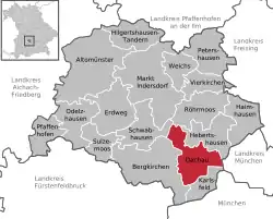 | |
 Dachau, Bavaria  Dachau, Bavaria | |
| Coordinates: 48°15′37″N 11°26′3″E | |
| Country | Germany |
| State | Bavaria |
| Admin. region | Upper Bavaria |
| District | Dachau |
| Government | |
| • Lord mayor | Florian Hartmann (SPD) |
| Area | |
| • Total | 34.85 km2 (13.46 sq mi) |
| Elevation | 482 m (1,581 ft) |
| Population (2022-12-31)[1] | |
| • Total | 48,195 |
| • Density | 1,400/km2 (3,600/sq mi) |
| Time zone | UTC+01:00 (CET) |
| • Summer (DST) | UTC+02:00 (CEST) |
| Postal codes | 85221 |
| Dialling codes | 08131 |
| Vehicle registration | DAH |
| Website | http://www.dachau.de |
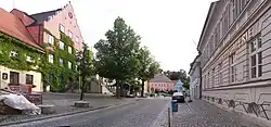
Dachau (German pronunciation: [ˈdaxaʊ]; Bavarian: Dochau) is a city in the south of Germany, about 20 kilometres (12.4 miles) north-west of Munich. It has about 40,000 inhabitants. The town contains a historic town centre with an 18th-century castle.
Dachau was founded in the 8th century. In 1933, a concentration camp was built in Dachau. It was the first camp of the Nazis and became the prototype for all other camps. More than 30,000 prisoners died or were killed.
References
- Genesis Online-Datenbank des Bayerischen Landesamtes für Statistik Tabelle 12411-003r Fortschreibung des Bevölkerungsstandes: Gemeinden, Stichtag (Einwohnerzahlen auf Grundlage des Zensus 2011) .
Other websites
![]() Media related to Dachau at Wikimedia Commons
Media related to Dachau at Wikimedia Commons
- Town Web site Archived 2006-10-06 at the Wayback Machine
Towns and municipalities in Dachau (district) | ||
|---|---|---|
Coat of Arms of Dachau district | ||
This article is issued from Wikipedia. The text is licensed under Creative Commons - Attribution - Sharealike. Additional terms may apply for the media files.