Cordillera Administrative Region
Cordillera Administrative Region is an administrative region in the Philippines. It is on the island of Luzon. The regional center is Baguio.
Cordillera Administrative Region
CAR | |
|---|---|
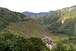   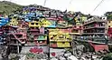 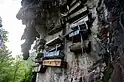 From top, left to right: Batad Rice Terraces; Tayum Church; Lubuagan, Kalinga; Colors of StoBoSa, Hanging coffins of Sagada | |
 Location in the Philippines | |
| Country | |
| Island group | Luzon |
| Regional center | Baguio |
| Area | |
| • Total | 19,422.03 km2 (7,498.89 sq mi) |
| Population (2015)[1] | |
| • Total | 1,722,006 |
| • Density | 89/km2 (230/sq mi) |
| Time zone | UTC+8 (PST) |
| ISO 3166 code | PH-15 |
| Provinces | |
| Cities | 2
|
| Municipalities | 75 |
| Barangays | 1,176 |
It was created on July 15, 1987. There are 6 provinces: Abra, Apayao, Benguet, Ifugao, Kalinga and Mountain Province.
Mount Pulag, the highest mountain in Luzon, is in the region. Rivers include the Chico River, Abulog, and Siffu River. Tourist sites include Banaue Rice Terraces, Cassamata Hill National Park, and Balbalasang-Balbalan National Park.
References
-
Census of Population (2015). "Cordillera Administrative Region (CAR)". Total Population by Province, City, Municipality and Barangay. PSA. Retrieved 20 June 2016.
{{cite encyclopedia}}: CS1 maint: numeric names: authors list (link)
This article is issued from Wikipedia. The text is licensed under Creative Commons - Attribution - Sharealike. Additional terms may apply for the media files.