Copeland, Kansas
Copeland is a city in Gray County, Kansas, United States. As of the 2020 census, 251 people lived there.[3]
Copeland, Kansas | |
|---|---|
 Location within Gray County and Kansas | |
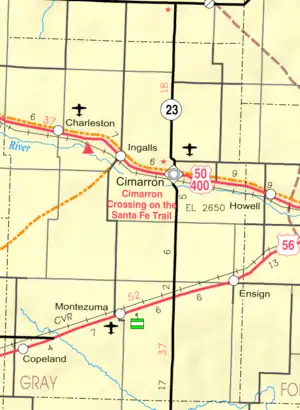 KDOT map of Gray County (legend) | |
| Coordinates: 37°32′24″N 100°37′42″W[1] | |
| Country | United States |
| State | Kansas |
| County | Gray |
| Founded | 1912 |
| Incorporated | 1927 |
| Named for | E.L. Copeland |
| Area | |
| • Total | 0.23 sq mi (0.60 km2) |
| • Land | 0.23 sq mi (0.60 km2) |
| • Water | 0.00 sq mi (0.00 km2) |
| Elevation | 2,822 ft (860 m) |
| Population | |
| • Total | 251 |
| • Density | 1,100/sq mi (420/km2) |
| Time zone | UTC-6 (CST) |
| • Summer (DST) | UTC-5 (CDT) |
| ZIP code | 67837 |
| Area code | 620 |
| FIPS code | 20-15475 |
| GNIS ID | 2393631[1] |
History
Copeland was founded in 1912.[4] It was named for E. L. Copeland, an official of the Santa Fe Railroad.[5]
The first post office in Copeland was founded in October 1912.[6]
Geography
Copeland is at 37°32′25″N 100°37′49″W (37.540199, -100.630236).[7]
According to the United States Census Bureau says that the city has a total area of 0.23 square miles (0.60 km2). All of it is land.[8]
People
| Historical population | |||
|---|---|---|---|
| Census | Pop. | %± | |
| 1930 | 423 | — | |
| 1940 | 262 | −38.1% | |
| 1950 | 242 | −7.6% | |
| 1960 | 247 | 2.1% | |
| 1970 | 267 | 8.1% | |
| 1980 | 323 | 21.0% | |
| 1990 | 290 | −10.2% | |
| 2000 | 339 | 16.9% | |
| 2010 | 310 | −8.6% | |
| 2020 | 251 | −19.0% | |
| U.S. Decennial Census | |||
2020 census
The 2020 census says that there were 251 people, 93 households, and 71 families living in Copeland. Of the households, 83.9% owned their home and 16.1% rented their home.
The median age was 41.5 years. Of the people, 93.6% were White, 2.8% were from some other race, and 3.6% were two or more races. Hispanic or Latino of any race were 11.6% of the people.[3][9]
Education
South Gray Schools has two parts: Copeland USD 476 and Montezuma USD 371. They include an Elementary school and Junior High School in Copeland, and an Elementary and High School in Montezuma.[11]
Before to school unification, Copeland was home to Copeland High School, which had a mascot known as the Vikings.[12]
References
- U.S. Geological Survey Geographic Names Information System: Copeland, Kansas
- "2019 U.S. Gazetteer Files". United States Census Bureau. Retrieved July 24, 2020.
- "DP1: PROFILE OF GENERAL POPULATION AND HOUSING CHARACTERISTICS". United States Census Bureau. Retrieved December 12, 2023.
- "Gray County". Blue Skyways. Kansas State Library. Archived from the original on 5 June 2001. Retrieved 10 June 2014.
- "Profile for Copeland, Kansas". ePodunk. Archived from the original on 14 July 2014. Retrieved 10 June 2014.
- "Kansas Post Offices, 1828-1961 (archived)". Kansas Historical Society. Archived from the original on October 9, 2013. Retrieved 10 June 2014.
- "US Gazetteer files: 2010, 2000, and 1990". United States Census Bureau. 2011-02-12. Retrieved 2011-04-23.
- "2020 U.S. Gazetteer Files". United States Census Bureau. Retrieved December 12, 2023.
- "P16: HOUSEHOLD TYPE". United States Census Bureau. Retrieved December 30, 2023.
- "American FactFinder". United States Census Bureau. Retrieved 2012-07-06.
- "USD 371". South Gray Schools. Retrieved 5 January 2017.
- "Copeland Marked By Inexperience", Garden City Telegram, 1 September 1978, p.43.
Other websites
- City
- Schools
- USD 476, local school district
- Maps
- Copeland City Map, KDOT
Municipalities and communities of Gray County, Kansas, United States | ||
|---|---|---|
| Cities | 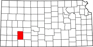 Map of Kansas highlighting Gray County | |
| Unincorporated communities |
| |
| Townships |
| |