Clay County, West Virginia
Clay County is a county in the U.S. state of West Virginia.
Charleston (capital) | ||
| Topics |
|  Seal of West Virginia |
| Insignia | ||
| Regions | ||
| Largest cities | ||
| Counties |
| |
Clay County | |
|---|---|
 The Old Clay County Courthouse in Clay in 2007 | |
 Location within the U.S. state of West Virginia | |
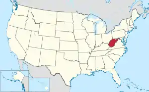 West Virginia's location within the U.S. | |
| Coordinates: 38°28′N 81°04′W | |
| Country | |
| State | |
| Founded | March 29, 1858 |
| Named for | Henry Clay |
| Seat | Clay |
| Largest town | Clay |
| Area | |
| • Total | 344 sq mi (890 km2) |
| • Land | 342 sq mi (890 km2) |
| • Water | 1.9 sq mi (5 km2) 0.5% |
| Population (2020) | |
| • Total | 8,051 |
| • Density | 23/sq mi (9.0/km2) |
| Time zone | UTC−5 (Eastern) |
| • Summer (DST) | UTC−4 (EDT) |
| Congressional district | 1st |
| Website | www |
This article is issued from Wikipedia. The text is licensed under Creative Commons - Attribution - Sharealike. Additional terms may apply for the media files.