Chauffour-lès-Étréchy
Chauffour-lès-Étréchy is a commune. It is in Île-de-France in the Essonne department in north France.
Chauffour-lès-Étréchy | |
|---|---|
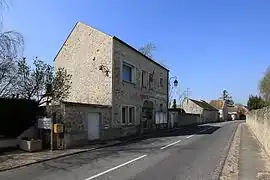 The town hall in Chauffour-lès-Étréchy | |
Location of Chauffour-lès-Étréchy | |
 Chauffour-lès-Étréchy 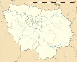 Chauffour-lès-Étréchy | |
| Coordinates: 48°30′10″N 2°10′09″E | |
| Country | France |
| Region | Île-de-France |
| Department | Essonne |
| Arrondissement | Étampes |
| Canton | Dourdan |
| Intercommunality | Entre Juine et Renarde |
| Government | |
| • Mayor (2020–2026) | Fabien Pigeon |
| Area 1 | 4.80 km2 (1.85 sq mi) |
| Population | 137 |
| • Density | 29/km2 (74/sq mi) |
| Time zone | UTC+01:00 (CET) |
| • Summer (DST) | UTC+02:00 (CEST) |
| INSEE/Postal code | 91148 /91580 |
| Elevation | 95–159 m (312–522 ft) |
| 1 French Land Register data, which excludes lakes, ponds, glaciers > 1 km2 (0.386 sq mi or 247 acres) and river estuaries. | |
References
- "Populations légales 2019". The National Institute of Statistics and Economic Studies. 29 December 2021.
This article is issued from Wikipedia. The text is licensed under Creative Commons - Attribution - Sharealike. Additional terms may apply for the media files.