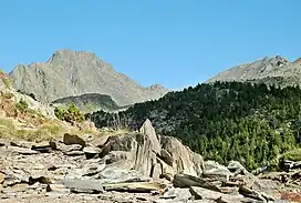
Carlit
Pic Carlit (French: Pic Carlit; Catalan: Puig Carlit) is a mountain of the French Pyrenees and has an elevation of 2,921 m (9,583 ft) above sea level.[2]
| Pic Carlit | |
|---|---|
| Puig Carlit | |
 Carlit Peak from Lanoux lake | |
| Highest point | |
| Elevation | 2,921 m (9,583 ft)[1] |
| Prominence | 1,001 m (3,284 ft) |
| Parent peak | Massif du Carlit |
| Coordinates | 42°34′11″N 01°55′55″E |
| Geography | |
 Pic Carlit | |
| Parent range | Pyrenees |
| Climbing | |
| First ascent | 1864 by Henry Russell |
| Easiest route | Hiking from the Bouillouses lake |
It is the highest point of the department of Pyrénées-Orientales and of the region Languedoc-Roussillon, France.
Geography
Pic Carlit is in the nortwestern part of the Regional Natural Park of the Catalan Pyrenees (French: Parc naturel régional des Pyrénées catalanes; Catalan: Parc Natural Regional del Pirineu Català, often shortened as Parc del Pirineu Català).
There are many small lakes in the region around the mountain. One of them is the man-made lake of Bouillouses, which is one of the point to begin hiking to get to the top of Pic Carlit.
The source of Têt (the largest river of the department Pyrénées-Orientales) is on the northeastern side of the mountain.
History
The first ascent of this peak was made by Henry Russell in 1864.[3]
References
- "Le reliefs des Pyrénées-Orientales" (in French). A la découverte des Pyrénées Catalanes. Retrieved 7 July 2013.
- "Pic Carlit, France". Peakbagger.com. Retrieved 7 July 2013.
- "Les "premières" de Russell" (in French). Henry Russell-Killoug - Comte des Pyrénées. Retrieved 7 July 2013.