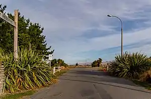
Bexley, New Zealand
Bexley is an eastern suburb of Christchurch. It is on the west bank of the Avon River and borders the suburb of Aranui. State Highway 74 runs through the suburb and suffered from earthquake damage in 2010 and 2011.
Bexley | |
|---|---|
 Bexley Park | |
| Coordinates: 43°30′50″S 172°42′50″E | |
| Country | New Zealand |
| City | Christchurch |
| Local authority | Christchurch City Council |
| Electoral ward | Burwood |
| Area | |
| • Land | 90 ha (220 acres) |
| Population (June 2022)[2] | |
| • Total | 2,660 |
| Aranui | ||
| Wainoni |
|
(Residential red zone) |
| Bromley |
References
- "ArcGIS Web Application". statsnz.maps.arcgis.com. Retrieved 2 October 2021.
- "Population estimate tables - NZ.Stat". Statistics New Zealand. Retrieved 25 October 2022.
This article is issued from Wikipedia. The text is licensed under Creative Commons - Attribution - Sharealike. Additional terms may apply for the media files.