Beattie, Kansas
Beattie is a city in Marshall County, Kansas, United States. In 2020, 197 people lived there.[3] The city has been called "The Milo Capital of the World" and hosts the annual "Beattie Milo Festival".[4]
Beattie, Kansas | |
|---|---|
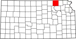
 Location within Marshall County and Kansas | |
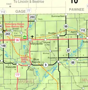 KDOT map of Marshall County (legend) | |
| Coordinates: 39°51′45″N 96°25′04″W[1] | |
| Country | United States |
| State | Kansas |
| County | Marshall |
| Platted | 1870 |
| Incorporated | 1884 |
| Named for | Armstrong Beattie |
| Area | |
| • Total | 0.23 sq mi (0.59 km2) |
| • Land | 0.23 sq mi (0.59 km2) |
| • Water | 0.00 sq mi (0.00 km2) |
| Elevation | 1,326 ft (404 m) |
| Population | |
| • Total | 197 |
| • Density | 860/sq mi (330/km2) |
| Time zone | UTC-6 (CST) |
| • Summer (DST) | UTC-5 (CDT) |
| ZIP code | 66406 |
| Area code | 785 |
| FIPS code | 20-04900 |
| GNIS ID | 2394097[1] |
History
Beattie was planned out in 1870.[5] It is named after Armstrong Beattie, the eighth Mayor of St. Joseph, Missouri.[6]
The first post office in Beattie was created in July 1871.[7]
Geography
Beattie is at 39°51′42″N 96°25′9″W (39.861736, -96.419091).[8] The United States Census Bureau says that the city has a total area of 0.23 square miles (0.60 km2). All of it is land.[2]
People
| Historical population | |||
|---|---|---|---|
| Census | Pop. | %± | |
| 1880 | 270 | — | |
| 1890 | 648 | 140.0% | |
| 1900 | 633 | −2.3% | |
| 1910 | 497 | −21.5% | |
| 1920 | 452 | −9.1% | |
| 1930 | 434 | −4.0% | |
| 1940 | 389 | −10.4% | |
| 1950 | 321 | −17.5% | |
| 1960 | 314 | −2.2% | |
| 1970 | 288 | −8.3% | |
| 1980 | 316 | 9.7% | |
| 1990 | 221 | −30.1% | |
| 2000 | 277 | 25.3% | |
| 2010 | 200 | −27.8% | |
| 2020 | 197 | −1.5% | |
| U.S. Decennial Census | |||
2020 census
The 2020 census says that there were 197 people, 86 households, and 53 families living in Beattie. Of the households, 80.2% owned their home and 19.8% rented their home.
The median age was 47.5 years. Of the people, 90.9% were White, 1.5% were Black, 1.5% were Native American, 0.5% were from some other race, and 5.6% were two or more races. Hispanic or Latino of any race were 2.5% of the people.[3][9]
References
- U.S. Geological Survey Geographic Names Information System: Beattie, Kansas
- "2020 U.S. Gazetteer Files". United States Census Bureau. Retrieved November 30, 2023.
- "DP1: PROFILE OF GENERAL POPULATION AND HOUSING CHARACTERISTICS". United States Census Bureau. Retrieved November 30, 2023.
- "City of Beattie". Archived from the original on 2007-05-27. Retrieved 2007-06-09.
- Kansas State Historical Society (1916). Biennial Report of the Board of Directors of the Kansas State Historical Society. Kansas State Printing Plant. p. 236.
- Blackmar, Frank Wilson (1912). Kansas: A Cyclopedia of State History, Embracing Events, Institutions, Industries, Counties, Cities, Towns, Prominent Persons, Etc. Standard Publishing Company. p. 163. ISBN 9780722249055.
- "Kansas Post Offices, 1828-1961 (archived)". Kansas Historical Society. Archived from the original on October 9, 2013. Retrieved 14 June 2014.
- "US Gazetteer files: 2010, 2000, and 1990". United States Census Bureau. 2011-02-12. Retrieved 2011-04-23.
- "P16: HOUSEHOLD TYPE". United States Census Bureau. Retrieved December 30, 2023.
- "American FactFinder". United States Census Bureau. Retrieved 2012-07-06.
Other websites
- City
- Schools
- USD 364 Archived 2011-10-03 at the Wayback Machine, local school district
- Maps
- Beattie City Map, KDOT
Municipalities and communities of Marshall County, Kansas, United States | ||
|---|---|---|
| Cities |
|  Map of Kansas highlighting Marshall County |
| CDP |
| |
| Unincorporated communities |
| |
| Ghost towns |
| |
| Townships |
| |