Bayerisch Eisenstein
Bayerisch Eisenstein, until 1951 just Eisenstein (Czech: Bavorská Železná Ruda) is a village and a municipality in Regen, in Bavaria, Germany.
Bayerisch Eisenstein | |
|---|---|
 Train station | |
 Coat of arms | |
Location of Bayerisch Eisenstein within Regen district 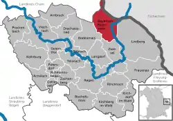 | |
 Bayerisch Eisenstein  Bayerisch Eisenstein | |
| Coordinates: 49°7′12″N 13°12′00″E | |
| Country | Germany |
| State | Bavaria |
| Admin. region | Niederbayern |
| District | Regen |
| Subdivisions | 8 districts |
| Government | |
| • Mayor (2020–26) | Michael Herzog[1] (CSU) |
| Area | |
| • Total | 47.34 km2 (18.28 sq mi) |
| Elevation | 724 m (2,375 ft) |
| Population (2022-12-31)[2] | |
| • Total | 993 |
| • Density | 21/km2 (54/sq mi) |
| Time zone | UTC+01:00 (CET) |
| • Summer (DST) | UTC+02:00 (CEST) |
| Postal codes | 94252 |
| Dialling codes | 09925 |
| Vehicle registration | REG |
| Website | www.bayerisch-eisenstein.de |
Geography
Bayerisch Eisenstein is part of Bayerischer Wald and borders the first German national park established in 1968.
It is one of three connected places in the area. The other two are Železná Ruda (German: Böhmisch Eisenstein or Markt Eisenstein) and Špičák (German: Dorf Eisenstein), both in Czech Republic. Železná Ruda is 2 kilometres northeast from Bayerisch Eisenstein. The town's railway station is split by the border. In August 2006 Bayerisch Eisenstein and Železná Ruda signed a twinning agreement
References
- Liste der ersten Bürgermeister/Oberbürgermeister in kreisangehörigen Gemeinden, Bayerisches Landesamt für Statistik, 15 July 2021.
- Genesis Online-Datenbank des Bayerischen Landesamtes für Statistik Tabelle 12411-003r Fortschreibung des Bevölkerungsstandes: Gemeinden, Stichtag (Einwohnerzahlen auf Grundlage des Zensus 2011) .
Other websites
- Official website
 (in German)
Towns and municipalities in Regen (district) | ||
|---|---|---|
Coat of arms | ||
This article is issued from Wikipedia. The text is licensed under Creative Commons - Attribution - Sharealike. Additional terms may apply for the media files.