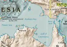
Arafura Sea

The Arafura Sea is west of the Pacific Ocean. It overlys the continental shelf between Australia and New Guinea.
Geography
The Arafura Sea is bordered by Torres Strait and through that the Coral Sea to the east, the Gulf of Carpentaria to the south, the Timor Sea to the west and the Banda and Ceram seas to the northwest. It is 1,290 kilometres (800 mi) long and 560 kilometres (350 mi) wide. The depth of the sea is mostly 50–80 metres (165–265 feet) with the depth increasing to the west. As a shallow tropical sea, its waters are the start for tropical cyclones.
The sea is over the Arafura Shelf, part of the Sahul Shelf. When sea levels were low during the last glacial maximum, the Arafura Shelf, the Gulf of Carpentaria and Torres Strait formed a large flat land bridge. The bridge connected Australia and New Guinea and let humans move from Asia into Australia. The combined landmass formed the continent of Sahul.
Other websites
![]() Media related to Arafura Sea at Wikimedia Commons
Media related to Arafura Sea at Wikimedia Commons