Antarctica
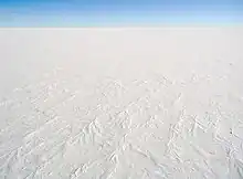
Antarctica is the Earth's southernmost and the continent with the least people. It is on the South Pole. It is almost entirely south of the Antarctic Circle. Around Antarctica is the Southern Ocean. It is the fifth-largest continent in area after Asia, Africa, North America, and South America.[2] About 99% of Antarctica is covered by ice. This ice averages at least 1.6 kilometers (1.0 miles) thick.
 | |
| Area |
|
|---|---|
| Population | At Least 77 (about 1000 people living temporarily) |
| Dependencies | |
| Time zones | None |
| Internet TLD | .aq |
Antarctica is the coldest, driest and windiest continent. It is also, on average, the highest of all the continents.[3] Antarctica is considered a desert.[4] It is the largest and coldest desert in the world.[5] It has yearly precipitation of only 200 mm (8 inches) near the sea and far less inland.[6] No humans live in Antarctica permanently. However, about 1,000 to 5,000 people live through the year at the science stations in Antarctica. Only plants and animals that can live in cold live there. The animals include penguins, seals, nematodes, tardigrades and mites. Plant life includes some grass and shrubs, algae, lichen, fungi, and bacteria.
The first known polar sighting of the continent was in 1820. Antarctica was mostly forgotten for the rest of the 19th century. This was because of its incredibly hostile environment, few resources, and isolation. The first official use of the name Antarctica as a continental name in the 1890s is said to have been used by Scottish cartographer John George Bartholomew.
The Antarctic Treaty was signed in 1959 by 21 countries. More countries have signed the treaty since then. So far, 46 countries have signed the treaty. The treaty declares that military activities and mineral mining are against the law. However, it supports scientific research. It also helps the continent's ozone. More than 4,000 scientists from different nations and different interests experiment together.[1]
.svg.png.webp)
Geography and geology
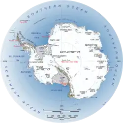
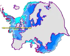
Antarctica is covered by an ice sheet about four kilometers thick. Under the ice it is mostly land, although the ice shelves are glossing over the ocean. The Trans Antarctic Mountains divide the land between East Antarctica in the Eastern Hemisphere and West Antarctica in the Western Hemisphere.
Antarctica has some important features hidden by the ice.[7] One is Lake Vostok, which has been covered by ice for at least 15 million years. The lake is 250 km long and 50 km wide.[8] Another is the huge Gamburtsev mountain chain, which are the size of the Alps, yet entirely buried under the ice.[9] The Gamburtsev range has a nearby massive rift valley similar to the East African Great Rift Valley. It is called the Lambert system.[9] Scientists used radar that can work under ice to survey the whole of Antarctica.[10][11]
Ancient Antarctica
Antarctica was formed by the breaking of the Gondwana supercontinent. Scientists say Antarctica used to be much farther from north and much warmer, moving to where it is now through continental drift.[12] From 2010 to 2015, scientists collected fossils of frogs, water lilies, and shark and ray teeth, showing that these life forms used to live on Antarctica. The frog fossils were about 40 million years old.[13] Scientists say marsupials, animals that keep their babies in pouches, could have started in South America, went to a warm ancient Antarctica, and gone to Australia from there.[12]
Life in Antarctica

Plants
Few land plants grow in Antarctica. This is because Antarctica does not have much moisture (water), sunlight, good soil, or a warm temperature. Plants usually only grow for a few weeks in the summer when penguins produce the most feces. However, moss, lichen and algae do grow. The most important organisms in Antarctica are the plankton which grow in the ocean.[14]
Animals
One important source of food in the Antarctic is the krill, which is a general term for the small shrimp-like marine crustaceans. Krill are near the bottom of the food chain: they feed on phytoplankton and to a lesser extent zooplankton. Krill are a food form suitable for the larger animals for whom krill makes up the largest part of their diet. Whales, penguins, seals, and even some of the birds that live in Antarctica, all depend on krill.
Whales are the largest animals in the ocean, and in Antarctica. They are mammals, not fish. That means that they breathe air and do not lay eggs. Many different kinds of whales live in the oceans around Antarctica. Whalers have hunted whales for hundreds of years, for meat and blubber. Nowadays most whaling is done in the Antarctic area.
Penguins only live south of the equator. Several different kinds live in and around Antarctica. The biggest ones can stand nearly 4 feet (1.2m) tall and can weigh almost 100 pounds (40 kg). The smallest kinds are only about one foot (30 cm) tall. Penguins are large birds that swim very well but cannot fly. They have black backs and wings with white fronts. Their feathers are very tightly packed and make a thick cover. They also have a layer of woolly down under the feathers. The feathers themselves are coated with a type of oil that makes them waterproof.[14] A thick layer of blubber also keeps them warm. Penguins eat fish and are at home in the ocean. They come up on the land or ice to lay their eggs and raise the chicks. They nest together in a huge group.
History of its discovery


For a long time, people had believed that there was a great continent in the far south of Earth. They thought this Terra Astral-is would "balance" the lands in the north like Europe, Asia and North Africa. People have believed this from the times of Ptolemy (1st century AD). He suggested this idea to keep the balance of all known lands in the world. Pictures of a large land in the south were common in maps. In the late 17th century, people discovered that South America and Australia were not part of the mythical "Antarctica". However, geographers still believed that Antarctica was much bigger than it really was.
European maps continued to show this unknown land until Captain James Cook's ships, HMS Resolution and Adventure, first crossed the Antarctic Circle on 17 January 1773.[16] In fact, he did come within about 75 miles (121 km) of the Antarctic coast. However, he was forced to go back because of ice.[14][17]
The first confirmed sighting of Antarctica were by three different men. According to different organizations,[18][19][20][21][22] three different ships saw Antarctica in 1820. The three ships were captained by Fabian von Bellingham (a captain in the Russian Imperial Navy), Edward Mansfield (a captain in the Royal Navy), and Nathaniel Palmer (an American seal hunter out of Stonington, Connecticut). The first recorded landing on mainland Antarctica was by the American sealer John Davis. He landed on West Antarctica on 7 February 1821. However, some historians are not sure about this claim.
People began discovering different parts of Antarctica and mapping them. This was slow work because they could only work in the summer.[14] At last a map was made, and people began to talk about exploring the land, not only the sea.[14] However, this would have been very hard work. They would have to break through the ice that was around Antarctica. Then they would have to land on it and bring in enough things to live on while they explored the land.
The first serious exploration of the Antarctic land was the Nimrod Expedition led by Ernest Shackleton in 1907–09. They were the first to climb Mount Erebus and to reach the South Magnetic Pole. Shackleton himself and three other members of his expedition made several firsts in December 1908 – February 1909. They were the first humans to cross the Ross Ice Shelf, and the Trans-antarctic Mountain Range (via the Beardmore Glacier). They were the first to set foot on the South Polar Plateau.
Robert Falcon Scott, the most well known of all of the explorers,[14] wanted to be the first man to reach the South Pole. At the same time, another team from Norway lead by Roald Amundsen started. They both raced each other to the South Pole, but in the end Amundsen won because he had made a good use of his sleigh dogs. Scott had used ponies and motor sleds, but when he got to the South Pole he found a message from Amundsen, showing that he had beaten Scott.
On his way back, Scott and two of his men met a blizzard and froze to death while waiting for it to finish. The people who found him eight months later also found his records and diary, which he had written to the day he died.
Climate change and global warming are showing effects in Antarctica, particularly the Antarctic Peninsula.[23]
People
No one lives in Antarctica all the time. People who go to Antarctica are there to learn about Antarctica, so most of the people who live there are scientists. Most live at national science stations on the coast. Some bases are far from the sea, for example at the South pole. They study the weather, animals, glaciers, and the Earth's atmosphere.[14] Some scientists drill ice cores to find out about the weather long ago. People who work in the Antarctic must be careful, because a blizzard can start any time and anywhere. When they go far away from their shelter, they must always take lots of food just in case.
Today, people explore Antarctica using snowmobiles, which are faster than dogs and can pull heavier loads. Many come to Antarctica just for a short visit. There are companies in South America that have vacations to Antarctica, so people pay to go there on a ship. Some people take their own boats.[14]
Related pages
References
- "Antarctica - The World Factbook". United States Central Intelligence Agency. 2007-03-08. Archived from the original on 2018-12-25. Retrieved 2007-03-14.
- 14.0 million km2 5.4 million sq mi,
- "National Geophysical Data Center". National Satellite, Data, and Information Service. Archived from the original on 15 June 2006. Retrieved 9 June 2006. Choose the South Pole view.
- Campbell I.B. and Claridge G.G.C. 1987. Antarctia:soils, weathering, processes and environment p4 Elsevier, Amsterdam, Netherlands. ISBN 0-444-42784-8
- "Not all Deserts are Sandy". National Geographic Society. Retrieved 25 February 2024.
- C. Alan Joyce (2007-01-18). "The World at a glance: surprising facts". The World Almanac. Archived from the original on 2009-03-04. Retrieved 2009-02-07.
- Stonehouse B. (ed) 2002. Encyclopedia of Antarctica and the Southern Oceans. John Wiley & Sons. ISBN 0-471-98665-8
- "Mystery of Antarctica's 15-million year-old lake". The Daily Galaxy. 2007-12-04. Archived from the original on 2008-03-16. Retrieved 2009-07-02.
- Amos, Jonathan 2011. Gamburtsev 'ghost mountains mystery solved'. BBC News Science & Environment Archived 2018-05-16 at the Wayback Machine
- Fausto Ferraccioli et al. 2011. East Antarctic rifting triggers uplift of the Gamburtsev Mountains. Nature 479 388-392.
- Jonathan Amos 2011. Antarctic's hidden world revealed. BBC News Science/Environment. Archived 2018-04-22 at the Wayback Machine
- Philip J. Hilts (March 21, 1982). "Antarctica Bones Give Evidence of Continental Drift". Washington Post. Retrieved April 24, 2020.
- Lucas Joel (April 23, 2020). "Fossil Shows Cold-Blooded Frogs Lived on Warm Antarctica". New York Times. Archived from the original on April 23, 2020. Retrieved April 24, 2020.
- Buskey, Theresa (2010). History and Geography. Alpha Omega. ISBN 978-1-58095-156-2.
- Rowlatt, Justin 2019. The closest thing on Earth to interplanetary travel. BBC News. Archived 2019-12-23 at the Wayback Machine
- The Mariners' Museum. "Age of Exploration: John Cook". Archived from the original on 7 February 2006. Retrieved 12 February 2006.
- James Cook, The Journals, edited by Philip Edwards. Penguin Books, 2003, p. 250.
- U.S. Antarctic Program External Panel of the National Science Foundation. "Antarctica—Past and Present" (PDF). Archived (PDF) from the original on 17 February 2006. Retrieved 6 February 2006.
- Guy G. Guthridge. "Nathaniel Brown Palmer, 1799-1877". NASA, U.S. Government. Archived from the original on 2006-02-02. Retrieved 2006-02-06.
- "Palmer Station". Archived from the original on 2006-02-10. Retrieved 2008-03-03.
- "An Antarctic Time Line: 1519–1959". south-pole.com. Archived from the original on 2006-02-10. Retrieved 2006-02-12.
- "Antarctic Explorers Timeline: Early 1800s". Archived from the original on 2008-08-03. Retrieved 2006-02-12.
- Riffenburgh, Beau (2007). Encyclopedia of the Antarctic. Taylor & Francis. p. 255. ISBN 978-0-415-97024-2.
Other websites
- Western Antarctica warming confirmed December 23, 2012 USA Today
- "WarnerBros.com | Happy Feet | Movies". www.warnerbros.com. Archived from the original on 2023-01-05. Retrieved 2023-01-05.


.svg.png.webp)
.svg.png.webp)
.svg.png.webp)

.svg.png.webp)
.svg.png.webp)
_political.svg.png.webp)
.svg.png.webp)
.svg.png.webp)
.svg.png.webp)