Alameda, California
Alameda is a city in the U.S. state of California. It is next to Oakland and the San Francisco Bay.
Alameda, California | |
|---|---|
_2.JPG.webp) City Hall | |
 Flag  Seal | |
| Nickname: The Island City | |
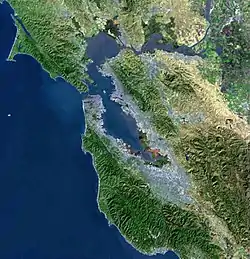
 Location in the state of California and Alameda County | |
| Coordinates: 37°45′22″N 122°16′28″W | |
| Country | |
| State | |
| County | Alameda |
| Area | |
| • Total | 22.98 sq mi (59.52 km2) |
| • Land | 10.45 sq mi (27.06 km2) |
| • Water | 12.53 sq mi (32.45 km2) 53.79% |
| Elevation | 33 ft (12.8 m) |
| Population | |
| • Total | 78,280 |
| • Density | 7,491.63/sq mi (2,892.62/km2) |
| Demonym | Alamedan |
| Time zone | UTC−8 (Pacific Standard Time Zone) |
| • Summer (DST) | UTC−7 (Pacific Daylight Time) |
| ZIP code | 94501, 94502 |
| Area code(s) | 510, 341 |
| FIPS code | 06-00562 |
Most of Alameda is on an island (called Alameda Island). The other large part is a peninsula connected to the Oakland International Airport. This peninsula is called Bay Farm Island because it used to be an island. The third part of Alameda is Coast Guard Island, which is a military base for the U.S. Coast Guard.
History
The city was founded in 1853 as 3 smaller towns. At the west end it was called Woodstock. The east end was called Fernside.
Alameda island was originally not an island. It was connected to Oakland. In 1902, a canal was finished that separated it from Oakland.
From 1917 to 1939 there was a popular amusement park called Neptune Beach.
In the 1940s the land was filled to make Bay Farm Island. A U.S. Navy base called Naval Air Station Alameda was opened in 1940. It was closed down in 1997.
Related pages
References
- "2020 U.S. Gazetteer Files". United States Census Bureau. Retrieved October 30, 2021.
| Bodies of water |
|  |
|---|---|---|
| Counties | ||
| Major cities | ||
| Cities and towns 100k–250k | ||
| Cities and towns 50k–99k | ||
| Cities and towns 25k-50k | ||
| Cities and towns 10k–25k |
| |
| Sub-regions | ||
| ||
Municipalities and communities of Alameda County, California, United States | ||
|---|---|---|
| Cities |  Alameda County map | |
| CDPs |
| |
| Unincorporated communities |
| |
| Annexed communities |
| |
| Former settlements |
| |