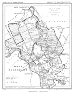
Map of Zwollerkerspel around Zwolle, 1867

City hall (1916-1967) of the former municipality of Zwollerkerspel, in the nowadays Ter Pelkwijkpark of Zwolle
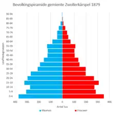
Population pyramid of the municipality on December 31 1879
Zwollerkerspel (Low Saxon: Zwollerkärspel) is a former municipality in the province of Overijssel, Netherlands. It covered the countryside around the city of Zwolle. Zwollerkerspel was a separate municipality from 1802 until August 1, 1967, when it became a part of Zwolle, Hasselt, Heino, IJsselmuiden and Genemuiden.[1]
See also
References
- ↑ Ad van der Meer and Onno Boonstra, "Repertorium van Nederlandse gemeenten", KNAW, 2006. "Repertorium van Nederlandse gemeenten 1812-2006". Archived from the original on February 20, 2007. Retrieved December 3, 2009.
External links
52°30′31″N 6°04′33″E / 52.5086°N 6.0759°E
This article is issued from Wikipedia. The text is licensed under Creative Commons - Attribution - Sharealike. Additional terms may apply for the media files.