Zlosyň | |
|---|---|
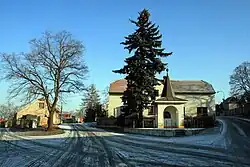 Centre of Zlosyň | |
 Flag  Coat of arms | |
 Zlosyň Location in the Czech Republic | |
| Coordinates: 50°16′41″N 14°22′7″E / 50.27806°N 14.36861°E | |
| Country | |
| Region | Central Bohemian |
| District | Mělník |
| First mentioned | 1316 |
| Area | |
| • Total | 5.88 km2 (2.27 sq mi) |
| Elevation | 179 m (587 ft) |
| Population (2023-01-01)[1] | |
| • Total | 500 |
| • Density | 85/km2 (220/sq mi) |
| Time zone | UTC+1 (CET) |
| • Summer (DST) | UTC+2 (CEST) |
| Postal code | 277 44 |
| Website | www |
Zlosyň is a municipality and village in Mělník District in the Central Bohemian Region of the Czech Republic. It has about 500 inhabitants.
Geography
Zlosyň is located about 19 kilometres (12 mi) north of Prague. It lies in the Central Elbe Table.
History
The first written mention of Zlosyň is from 1316. According to a record from 1654, the village was probably destroyed during the Thirty Years' War and later restored. For centuries, the village was agricultural, but in the 19th century, residents began to commute to work in nearby industrial centres.[2]
Transport
the D8 motorway from Prague to Ústí nad Labem passes through the municipality.
Sights
The main landmark of Zlosyň and the most valuable building is the Baroque granary. In the centre of Zlosyň is a chapel from 1942.[3]
References
- ↑ "Population of Municipalities – 1 January 2023". Czech Statistical Office. 2023-05-23.
- ↑ "Historie obce" (in Czech). Obec Zlosyň. Retrieved 2023-02-07.
- ↑ "Památky v obci" (in Czech). Obec Zlosyň. Retrieved 2023-02-07.