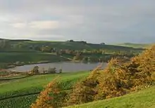
Yetholm Loch. Looking towards Lochside from Yetholm Law
Yetholm Loch is a loch near Kelso, in the Scottish Borders area of Scotland, in the former Roxburghshire.[1]
There was a tower on an island in Yetholm Loch which could be reached via a causeway. The tower was destroyed by the Earl of Surrey on the night of 17 May 1523.[2]
The loch lies in a crescent-shaped valley, at the edge of the Cheviot Hills. The southern end of the loch is swamp, but it gradually gives way to fen and willow scrub.
See also
Wikimedia Commons has media related to Yetholm Loch.
References
- ↑ Ordnance Survey: Landranger map sheet 74 Kelso & Coldstream (Jedburgh & Duns) (Map). Ordnance Survey. 2008. ISBN 9780319231388.
- ↑ Historic Environment Scotland. "Loch Tower, Yetholm Loch (59318)". Canmore. Retrieved 26 October 2016.
External links
- SSSI CITATION, 17 October 1983
- RCAHMS record of Loch Tower, Yetholm Loch
- Scottish Borders Council: Standing Open Water Habitat Action Plan
- Scottish Environment Protection Agency: Catchment Pollution Reduction Programme under Directive 78/659.EEC
- Geograph image: Yetholm Loch from Fourmartdean
55°33′N 2°19′W / 55.550°N 2.317°W
This article is issued from Wikipedia. The text is licensed under Creative Commons - Attribution - Sharealike. Additional terms may apply for the media files.