Yaft Rural District
Persian: دهستان يافت | |
|---|---|
 Yaft Rural District | |
| Coordinates: 38°44′59″N 47°33′13″E / 38.74972°N 47.55361°E[1] | |
| Country | |
| Province | Ardabil |
| County | Meshgin Shahr |
| District | Moradlu |
| Capital | Kanchubeh |
| Population (2016)[2] | |
| • Total | 2,419 |
| Time zone | UTC+3:30 (IRST) |
Yaft Rural District (Persian: دهستان يافت) is in Moradlu District of Meshgin Shahr County, Ardabil province, Iran. Its capital is the village of Kanchubeh.[3]
At the census of 2006, its population was 3,493 in 544 households.[4] There were 2,900 inhabitants in 710 households at the following census of 2011.[5] In the most recent census of 2016, the population of the rural district was 2,419 in 666 households. The largest of its 14 villages was Mashiran, with 815 people.[2]
The 14th-century author Hamdallah Mustawfi listed Yāft in his Nuzhat al-Qulub as a forested district comprising about 20 villages.[6] He wrote that it had a warm climate, produced grain and some fruit, and was assessed at a tax value of 4,000 dinars.[6]
References
- ↑ OpenStreetMap contributors (28 March 2023). "Yaft Rural District (Meshgin Shahr County)" (Map). OpenStreetMap. Retrieved 28 March 2023.
- 1 2 "Census of the Islamic Republic of Iran, 1395 (2016)". AMAR (in Persian). The Statistical Center of Iran. p. 24. Archived from the original (Excel) on 22 March 2019. Retrieved 19 December 2022.
- ↑ Mousavi, Mirhossein (18 May 1366). "Creation and formation of 30 rural districts including villages, farms and places in Ahar County under East Azerbaijan province". Islamic Council Research Center (in Persian). Ministry of Interior, Board of Ministers. Archived from the original on 26 October 2010. Retrieved 29 November 2023.
- ↑ "Census of the Islamic Republic of Iran, 1385 (2006)". AMAR (in Persian). The Statistical Center of Iran. p. 24. Archived from the original (Excel) on 20 September 2011. Retrieved 25 September 2022.
- ↑ "Census of the Islamic Republic of Iran, 1390 (2011)". Syracuse University (in Persian). The Statistical Center of Iran. p. 24. Archived from the original (Excel) on 15 January 2023. Retrieved 19 December 2022.
- 1 2 Hamdallah Mustawfi (1919). Le Strange, Guy (ed.). The Geographical Part of the Nuzhat-al-Qulub. p. 86. Retrieved 10 October 2022.
| Capital | 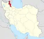 | ||||||||||||||||||||||
|---|---|---|---|---|---|---|---|---|---|---|---|---|---|---|---|---|---|---|---|---|---|---|---|
| Counties and cities |
| ||||||||||||||||||||||
| Landmarks |
| ||||||||||||||||||||||
| Places | |||||||||||||||||||||||
This article is issued from Wikipedia. The text is licensed under Creative Commons - Attribution - Sharealike. Additional terms may apply for the media files.