Winterland | |
|---|---|
Town | |
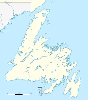
 Winterland Location of Winterland in Newfoundland  Winterland Winterland (Canada) | |
| Coordinates: 47°09′04″N 55°18′51″W / 47.15111°N 55.31417°W | |
| Country | Canada |
| Province | Newfoundland and Labrador |
| Population (2021) | |
| • Total | 398 |
| Time zone | UTC−03:30 (NST) |
| • Summer (DST) | UTC−02:30 (NDT) |
| Area code | 709 |
Winterland is a town in the Canadian province of Newfoundland and Labrador. The town is considered to be a bedroom community of Marystown.
Climate
Winterland has a humid continental climate (Dfb). The seasonal lag is unusual for the Atlantic coast with August being the warmest month and September closer to July than to June. February is the coldest month, especially with low temperatures. Winter lasts from mid-November through early April.
| Climate data for Winterland | |||||||||||||
|---|---|---|---|---|---|---|---|---|---|---|---|---|---|
| Month | Jan | Feb | Mar | Apr | May | Jun | Jul | Aug | Sep | Oct | Nov | Dec | Year |
| Record high °C (°F) | 13.0 (55.4) |
14.0 (57.2) |
15.0 (59.0) |
18.0 (64.4) |
24.5 (76.1) |
27.0 (80.6) |
29.5 (85.1) |
30.0 (86.0) |
29.0 (84.2) |
21.5 (70.7) |
18.0 (64.4) |
13.0 (55.4) |
30.0 (86.0) |
| Mean daily maximum °C (°F) | −0.5 (31.1) |
−0.6 (30.9) |
1.9 (35.4) |
6.5 (43.7) |
12.2 (54.0) |
16.3 (61.3) |
20.7 (69.3) |
21.3 (70.3) |
17.5 (63.5) |
12.0 (53.6) |
6.8 (44.2) |
2.2 (36.0) |
9.7 (49.5) |
| Daily mean °C (°F) | −4.0 (24.8) |
−4.3 (24.3) |
−1.8 (28.8) |
2.7 (36.9) |
7.3 (45.1) |
11.4 (52.5) |
15.9 (60.6) |
16.8 (62.2) |
13.3 (55.9) |
8.2 (46.8) |
3.6 (38.5) |
−0.9 (30.4) |
5.7 (42.3) |
| Mean daily minimum °C (°F) | −7.5 (18.5) |
−8.1 (17.4) |
−5.4 (22.3) |
−1.2 (29.8) |
2.5 (36.5) |
6.4 (43.5) |
11.2 (52.2) |
12.3 (54.1) |
9.0 (48.2) |
4.5 (40.1) |
0.4 (32.7) |
−3.9 (25.0) |
1.7 (35.1) |
| Record low °C (°F) | −21.0 (−5.8) |
−26.0 (−14.8) |
−22.5 (−8.5) |
−14.0 (6.8) |
−7.0 (19.4) |
−1.0 (30.2) |
1.0 (33.8) |
4.0 (39.2) |
0.0 (32.0) |
−6.0 (21.2) |
−13.0 (8.6) |
−20.0 (−4.0) |
−26.0 (−14.8) |
| Average precipitation mm (inches) | 128.9 (5.07) |
126.0 (4.96) |
118.6 (4.67) |
118.9 (4.68) |
111.9 (4.41) |
108.1 (4.26) |
92.3 (3.63) |
91.7 (3.61) |
145.8 (5.74) |
159.9 (6.30) |
142.1 (5.59) |
133.9 (5.27) |
1,478.1 (58.19) |
| Average rainfall mm (inches) | 66.0 (2.60) |
75.7 (2.98) |
93.5 (3.68) |
106.0 (4.17) |
111.3 (4.38) |
108.1 (4.26) |
92.3 (3.63) |
91.7 (3.61) |
145.8 (5.74) |
159.5 (6.28) |
133.4 (5.25) |
95.7 (3.77) |
1,279 (50.35) |
| Average snowfall cm (inches) | 62.9 (24.8) |
50.3 (19.8) |
25.1 (9.9) |
12.9 (5.1) |
0.6 (0.2) |
0 (0) |
0 (0) |
0 (0) |
0 (0) |
0.5 (0.2) |
8.7 (3.4) |
38.2 (15.0) |
199.2 (78.4) |
| Average precipitation days (≥ 0.2 mm) | 13.6 | 12.4 | 10.4 | 10.0 | 10.5 | 9.8 | 9.2 | 9.3 | 9.6 | 11.8 | 12.5 | 13.2 | 132.1 |
| Average rainy days (≥ 0.2 mm) | 5.1 | 5.4 | 6.2 | 8.4 | 10.3 | 9.8 | 9.2 | 9.3 | 9.6 | 11.7 | 11.1 | 8.3 | 104.4 |
| Average snowy days (≥ 0.2 cm) | 9.2 | 7.5 | 4.8 | 1.8 | 0.1 | 0.0 | 0.0 | 0.0 | 0.0 | 0.1 | 1.6 | 5.6 | 30.7 |
| Source: Environment and Climate Change Canada[1] | |||||||||||||
Demographics
In the 2021 Census of Population conducted by Statistics Canada, Winterland had a population of 398 living in 166 of its 224 total private dwellings, a change of 2.1% from its 2016 population of 390. With a land area of 54.44 km2 (21.02 sq mi), it had a population density of 7.3/km2 (18.9/sq mi) in 2021.[2]
See also
References
- ↑ "Canadian Climate Normals 1981-2010 Station Data Winterland". Environment and Climate Change Canada. 31 October 2011. Retrieved 17 August 2019.
- ↑ "Population and dwelling counts: Canada, provinces and territories, census divisions and census subdivisions (municipalities), Newfoundland and Labrador". Statistics Canada. February 9, 2022. Retrieved March 15, 2022.
External links
This article is issued from Wikipedia. The text is licensed under Creative Commons - Attribution - Sharealike. Additional terms may apply for the media files.