Westend | |
|---|---|
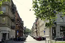
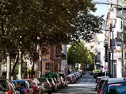 Typical street in Westend | |
 Coat of arms | |
Location of Westend in Wiesbaden 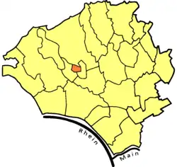 | |
 Westend  Westend | |
| Coordinates: 50°04′49″N 8°13′46″E / 50.08028°N 8.22944°E | |
| Country | Germany |
| State | Hesse |
| District | Urban district |
| City | Wiesbaden |
| Government | |
| • Local representative | Volker Wild (Greens) |
| Area | |
| • Total | 0.67 km2 (0.26 sq mi) |
| Population (2020-12-31)[1] | |
| • Total | 18,226 |
| • Density | 27,000/km2 (70,000/sq mi) |
| Time zone | UTC+01:00 (CET) |
| • Summer (DST) | UTC+02:00 (CEST) |
| Postal codes | 65183 |
| Dialling codes | 0611 |
Street in Westend borough
Westend is a borough of the city of Wiesbaden, Hesse, Germany. With a density of about 27,000 inhabitants per km² it is the most densely populated urban district in Germany. It is located in the centre of the city.
References
- ↑ "Bevölkerung in den Ortsbezirken am 31. Dezember 2020". Landeshauptstadt Wiesbaden. Retrieved 22 September 2021.
Sources
- Derived from German Wikipedia
External links
- Official Wiesbaden-Westend website (in German)
Boroughs of Wiesbaden | ||
|---|---|---|
| ||
| ||
Wikimedia Commons has media related to Wiesbaden-Westend.
This article is issued from Wikipedia. The text is licensed under Creative Commons - Attribution - Sharealike. Additional terms may apply for the media files.