| White Chuck River | |
|---|---|
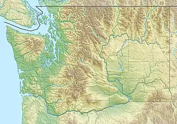 Location of the mouth of the White Chuck River in Washington  White Chuck River (the United States) | |
| Location | |
| Country | United States |
| State | Washington |
| Region | Snohomish County |
| Physical characteristics | |
| Source | Glacier Peak |
| • location | Cascade Range |
| • coordinates | 48°2′43″N 121°9′42″W / 48.04528°N 121.16167°W[1] |
| • elevation | 5,788 ft (1,764 m)[2] |
| Mouth | Sauk River |
• coordinates | 48°10′22″N 121°28′20″W / 48.17278°N 121.47222°W[1] |
• elevation | 912 ft (278 m)[2] |
| Length | 23 mi (37 km)[2] |
The White Chuck River is a river in the U.S. state of Washington. It is a tributary of the Sauk River.
Course
The White Chuck River originates on the slopes of Glacier Peak in the Cascade Range, near White Chuck Cinder Cone.[3] It flows generally northwest to join the Sauk River south of Darrington. The Sauk River in turn joins the Skagit River, which empties into Skagit Bay, part of Puget Sound.[4]
See also
References
- 1 2 U.S. Geological Survey Geographic Names Information System: White Chuck River
- 1 2 3 Calculated via Google Earth
- ↑ "White Chuck Cinder Cone — Coolest volcanic cone north of Lassen". Hike of the Week. 2014-09-11. Retrieved 2016-10-10.
- ↑ Washington Water Year 2005, USGS Water Resources Data
This article is issued from Wikipedia. The text is licensed under Creative Commons - Attribution - Sharealike. Additional terms may apply for the media files.