.jpg.webp)
Wharves in Wellington Harbour have been essential to the operation of the Port of Wellington, and to the development of the city and the lower half of the North Island of New Zealand.
As of 2023, there are 20 wharves situated around Wellington Harbour. This includes large wharves in the inner harbour and port area, smaller wharves in seaside suburbs and the fuel wharves at Point Howard and Evans Bay. The first wharves were built from 1840 by newly-arrived European settlers, to enable them to move goods from ship to shore. The first publicly-owned wharf built in Wellington Harbour was Queens Wharf, completed in 1862. In 1880 the Wellington Harbour Board was created and took control of most wharves in the harbour until its disestablishment in 1989.
At that time a commercial company, Port of Wellington (now called CentrePort Wellington) took over management of most industrial wharves, while Wellington City Council and Hutt City Council gained control of most suburban wharves. Wharves were built for various purposes – moving fuel, primary products such as timber, wool and meat coming from the hinterland, other goods and passengers. Wharves for passenger ferries included ferries taking commuters and day trippers to and from the city and suburbs, and larger inter-island ferries going to Picton and Lyttelton. The wharves also serviced passenger liners from overseas, and TEAL flying boats. Over time Wellington's wharves have been altered, upgraded, extended, truncated or buried in reclamation along the shoreline of Wellington Harbour. Many wharves have been repurposed in response to changing domestic and international conditions and requirements for maritime transport of passengers and cargo.
Inner harbour
Early private wharves
Wellington Harbour's first wharves were privately owned, built by businessmen to facilitate movement of goods from ships to warehouses and shops. Goods were transhipped from deep-sea vessels to lighters and then to the shore.[1] The names of these early private wharves changed as their ownership changed: for example, Hickson wharf was also known as Ridgway's Wharf, Will's Wharf and Houghton Wharf.[2]
The first wharf built may have been one constructed by J. H. Wallace, opposite Bowen Street. "Its construction was of the simplest. An empty dry-goods hogshead was carried out as far below low-water mark as it could be placed. When it was filled with stones it constituted the outer pier. Rough wooden trestles were placed at intervals in the intervening space, on which were laid some long straight logs, bound together by wooden ties, and squared on top by the nimble use of an adze."[1]
Other early wharves include Tod's Wharf, in operation by September 1840;[3] Taine's Wharf, built by James John Taine who arrived in Wellington in 1840 and soon built a wharf opposite his premises in Lambton Quay;[4] and Rhodes' Wharf, constructed in 1841 by 'Captain' William Barnard Rhodes.[5] He built a wharf near what is now the Michael Fowler Centre carpark at lower Cuba Street to provide access to his goods store and iron store.[6]: 11 [7][8] Baron Charles Ernest von Alzdorf, land agent and hotelier, built a wharf opposite his hotel.[9] Von Alzdorf died in the 1855 earthquake, and Alzdorf's Wharf was said to have been left high and dry fifty feet from the water after the earthquake raised the seabed.[10]
By the late 1850s many of these small private wharves were needing repairs and were no longer suitable for serving the larger ships then visiting Wellington.
Queens Wharf (1862)
From 1856 the Wellington Chamber of Commerce began calling on the Provincial Government to fund construction of a large publicly-owned wharf that could serve steamers on the Panama Line.[1][11][12] Queens Wharf, possibly named by local man Thomas McKenzie in honour of Queen Victoria,[13] opened in 1862 as Wellington's first public wharf and is Wellington's oldest extant wharf. The original wharf was constructed from timber, with totara piles. It was 550 ft (170 m) long with two cross tees extending 75 ft (23 m) on each side.[12]: 10 The wharf was extended several times as reclamation occurred in the harbour and ships got bigger, beginning in 1865–67 with a 200 ft (61 m) extension seawards, a new cross section 300 ft (91 m) long, extensions to the original cross sections, a steam crane and goods sheds.[12]: 10
Queens Wharf was managed by the Provincial Council and then Wellington City Council until the Wellington Harbour Board was created in 1880.[12] Queens Wharf became the Harbour Board's operational base, and was the port’s main wharf until the advent of container shipping in the 1970s.[14] Two historical buildings on Jervois Quay at the entrance to Queens Wharf date from the Harbour Board era: the Wellington Harbour Board Head Office and Bond Store (1892) and the Wellington Harbour Board Wharf Office Building (1896). Art Nouveau gates made of iron were installed in 1899 between these buildings at the wharf entrance.[15]
During the 1913 Great Strike strike, supporters broke through gates and barricades at Queen’s Wharf and King’s Wharf and boarded ships in an attempt to stop strike-breakers from working.[16] They also stopped goods vehicles and racehorses heading for Christchurch from entering Queens Wharf.[17][18]
In 1989 the Harbour Board was disestablished and a new company (Port of Wellington, now CentrePort Wellington) took over management of port operations. The seafront from Shed 21 near the Railway Station to Clyde Quay, which includes Queens Wharf, was handed to Wellington City Council. In the 1990s Lambton Harbour Management, a company controlled by Wellington City Council, was involved in developing Queens Wharf as an entertainment area. Two large buildings, the Queen Wharf Retail Centre and the Queens Wharf Events Centre, opened in 1995. The retail centre was an immediate failure and the building was sold in 1998.[19] The events centre, now known as the TSB Arena, still operates and hosts music concerts, sports and other events. Two old goods sheds on the wharf, Shed 3 and Shed 5, were turned into restaurants.[20][21]
In 2001, Waterfront Investments proposed to build a Hilton Hotel on the outer tee of Queens Wharf. Greater Wellington Regional Council supported the proposed hotel,[22] but a public survey showed that 86% of those surveyed did not want a hotel in this location.[23] In 2009 the Environment Court turned down the proposal, stating that "building a five-star hotel on a public wharf was inconsistent with the sustainable use of natural and physical resources".[22]
Three cranes are displayed on the wharf. One of them, a level luffing crane built in 1951 by Stothert & Pitt, is thought to be the only one of its type in New Zealand.[14][24] There is a Stothert & Pitt tripod gantry crane, one of ten bought in 1966 that operated on Glasgow Wharf until containerisation arrived,[24][25] and the third crane is a Series 520 Straddle Carrier, used in the early days of container shipping.[24]
There is a memorial to Paddy the Wanderer at the entrance to Queens Wharf, outside the Wharf Office Building. Paddy was a dog which used to roam the waterfront during the 1930s, befriending sailors and wharf workers. The memorial includes a bronze likeness of Paddy, a drinking fountain and drinking bowls below for dogs. Erected in 1945, it was paid for by Paddy's many friends and includes stones from London's Waterloo Bridge, bombed during World War II.[26]
- Views of Queens Wharf
.jpg.webp) Outer tee ca 1936-1942. Shed 3 in centre, Shed 5 in foreground.
Outer tee ca 1936-1942. Shed 3 in centre, Shed 5 in foreground.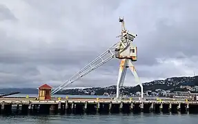 Tripod gantry crane on outer tee
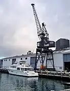 Level luffing crane
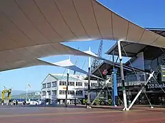 Shed 6 and TSB Arena
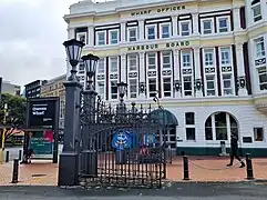 Gates and Harbour Board Wharf Offices building
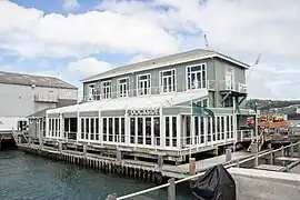 Dockside restaurant (formerly Shed 3)
Railway Wharf (1880)
Railway Wharf was Wellington's second deep-water wharf after Queens Wharf. It was built by the government and completed in April 1880 on newly reclaimed land near the Railway Station. Control of the wharf passed to the Wellington Harbour Board after the Wellington Harbour Board and Corporation Land Act came into effect on 1 September 1880.[25] From the start the wharf was designed to have rail access to facilitate handling of goods, and three separate lines were laid down. The wharf was angled on a north-north-west /south-south-east axis, the same as Queens Wharf, because at the time it was important to moor vessels "fore-and-aft" to Wellington's prevailing winds.[27] From 1906 to 1951, Railway Wharf was Wellington's main wharf for unloading coal. In 1951 the railway lines were removed and the wharf was extended and converted to become the base for the inter-island ferry to Lyttleton which had previously been at Waterloo Quay Wharf. Ferries to Picton also operated from this wharf.[25] The wharf was renamed the Inter-Island Wharf, with the first ferries berthing in 1954.[25] The wharf was altered again when roll-on/roll-off ferries were introduced, but after 1975 the wharf was no longer used by ferries.[25] Railway Wharf is managed by CentrePort.
Waterloo Quay Wharf (1883)
The wharf now known as Waterloo Quay Wharf was completed in 1883, the first wharf built after the Wellington Harbour Board was established in 1880. The wharf was built to serve the wool trade, and was known as Wool Wharf or Wool Jetty. A shed that could hold 6000 bales of wool was built at the city end of the wharf.[25] Originally the wharf was connected to land by a bridge, until the space between was reclaimed by 1906. Over the years the wharf has been altered and extended. In 1916 it was converted to serve the inter-island ferry to Lyttleton, and until 1953 was known at first as the Wellington-Lyttleton Ferry Wharf, and later the Lyttleton Wharf.[25] The ferry terminal was then moved to Railway Wharf, and from about that time Lyttleton Wharf became Waterloo Quay Wharf, used by coastal trading ships. For many years until 2009 the Police Maritime Unit operated from Shed 19 on the wharf.[28] The wharf was also used as a base for the Lynx and other fast ferries.[25] Waterloo Quay Wharf is controlled by CentrePort.
Ferry Wharf (1897)
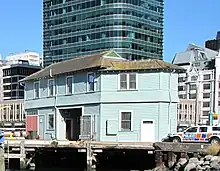
Ferry Wharf, also known as Ferry Wharf no. 1 to distinguish it from Tug Wharf (or Ferry Wharf no. 2) built beside it some years later, is located immediately west of Waterloo Quay Wharf. J H Williams had begun a ferry service to Days Bay in 1895, and Wellington Harbour Board wanted to take pressure off busy Queens Wharf. Ferry Wharf came into use in 1897,[29] with additions in 1906 and 1912–1914.[30] The wharf was connected to land by a bridge until reclamation was carried out. In 1912, Wellington Harbour Board built a ferry terminal building at the head of the wharf for the Wellington Ferry Company. Eastbourne Borough Council leased the building from the Harbour Board and operated a ferry service to Eastbourne until 1948.[28] The building then had various occupiers until 2009, when it became the base for the Police Maritime Unit and national dive squad.[30] The Eastbourne Ferry Building is listed as a Historic Place Category 2 by Heritage New Zealand.[31]
Glasgow Wharf (1901)
The Harbour Board approved plans and funding for a new road and railway wharf in 1898–1899, as part of a larger scheme of harbour reclamation and development.[32][33] The wharf was named Glasgow Wharf after the late governor, the Earl of Glasgow.[33] It was about 580 ft (180 m) long and 140 ft (43 m) wide and constructed of imported ironbark timber.[34][35] The wharf was completed in November 1901 for a cost of about £60,000 including sheds and cranes.[35] The Evening Post reported that "the wharf is in all respects the finest structure of the kind in the Southern hemisphere".[35] An innovative feature at the time was the installation of ten gantry cranes, built by the Hydraulic Engineering Company of Chester, which were said to be better for working on big ships than the cranes then in use at Queens Wharf.[36] The wharf handled frozen meat and produce needing cold storage.
The wharf has been upgraded several times. In 1966 the Harbour Board installed 10 new electric tripod gantry cranes. These were then made obsolete by the introduction of containerisation: one crane was restored and is now on display at Queens Wharf.[37]
From 1992 until 2004, Glasgow Wharf was the base for the Straitsman ferry, and since 2003 Bluebridge ferries have operated from the wharf.[37] The wharf is managed by CentrePort and is not open to the public.
Taranaki Street Wharf (1906)
In 1898, the chief engineer of Wellington Harbour Board suggested construction of a wharf opposite Taranaki Street, to be used mainly for moving coal but also for timber and produce. After preparatory reclamation and dredging, the wharf was built in 1906. The wharf was 152m long by 33 m wide and constructed from Australian hardwood. It had one fixed 20-ton hydraulic crane and 10 moveable 2-ton hydraulic cranes for shifting coal.[25] Ornamental gates at the entrance to the wharf are similar to those at Queens Wharf. They were installed in the 1930s, replacing earlier gates.[38]
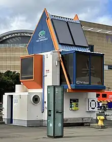
A major change to the wharf came in the late 1960s, when the wharf was converted for use by roll on/roll off ferries. A linkspan bridge with a control building designed by Roger Walker were completed in 1969.[25] The Union Steamship Company planned to operate a fortnightly freight service to Australia,[39] but the freight service was soon overtaken by the introduction of containerisation based at Thorndon.[25] The original bridge has since been replaced by a stylised version, and the building which housed machinery for operating the bridge is now used as a base by Wellington Free Ambulance.[40]
Land between Queens Wharf and Taranaki Street Wharf was reclaimed from 1969, allowing creation of Frank Kitts Park and Whairepo Lagoon and closing in the landward side of Taranaki Street Wharf. In 1989 two historic rowing club buildings were moved to the reclaimed area.[25]
In 2002 Wellington Waterfront Limited began transforming the Taranaki Street Wharf area to a public space. In 2011, Te Wharewaka o Poneke opened on reclaimed land between the wharf and the lagoon. This building is an enterprise by Taranaki iwi and Wellington Waterfront Limited. It houses two waka taua (ceremonial canoes) as well as a café and function rooms.[25] As of 2023, Taranaki Street Wharf is part of a waterfront public area and promenade stretching from Clyde Quay to Waterloo Quay, and is managed by Wellington City Council.
The floating crane Hikitia is berthed at Taranaki Wharf.
Kings Wharf (1909)

Kings Wharf is a timber wharf constructed between 1906 and 1909, parallel and to the east of Glasgow Wharf. Tenders for construction of the wharf and two double-storied sheds were accepted in September 1906 with Charles F Pulley as the builder. The wharf was 861 ft (262 m) long and 160 ft (49 m) wide. It was built on 903 ironbark timber piles, arranged in 42 bays each of 20 ft (6.1 m). The construction included two double-storied sheds (numbered 31 and 33) of timber construction. Railway tracks were provided each side of the wharf, and large mobile cranes on special tracks were used for handling cargo between railway wagons and the holds of ships at the wharf.[28][41] The wharf was completed in 1909, with the ceremony for the laying of the last block held on 26 March 1909.[28][42] It was the last major wharf to be built in timber, as concrete was used for all other wharf construction after 1909.[28]: 16–20
One of the notable vessels to berth at the wharf in the years immediately following its construction was HMS New Zealand, the Royal Navy battlecruiser of the Dreadnought era. The vessel had been funded for the Royal Navy by New Zealand as a gift. It berthed at Kings Wharf in June 1913, during the HMS New Zealand's 1913 circumnavigation.[43]
Later in 1913 the wharf was the location for a strike by waterside workers that was an early stage of the 1913 Great Strike.[44][45]
During the Second World War, another notable event at Kings's Wharf was the arrival of USS Wakefield on 14 June 1942, carrying around 6,000 US marines from the 1st Marine Division.[46][47]
In the 1960s, the Thorndon container terminal was built with reclamation of the land up to and including the east side of Kings Wharf.[48] However, berth 1 on the western side of Kings Wharf remains operational.[28]: 18 Kings Wharf was pushed sideways by the 2016 Kaikōura earthquake, but has been repaired.[49]
Clyde Quay Wharf (1910) and Overseas Passenger Terminal (1964)

Clyde Quay Wharf was completed in 1910 by the Wellington Harbour Board. Its location and purpose were controversial at the time[50] and it was never used as much as other wharves in the harbour.[51] The wharf was 560 ft (170 m) long and was the first wharf in Wellington built of reinforced concrete rather than timber.[52] It was also notable for a line of concrete arches 20 ft (6.1 m) high running the length of the wharf.[52] This was a crane track for electric cranes to run along, but initially the Harbour Board chose not to install a crane until it was proven necessary.[53] In 1961 the wharf was closed.
The wharf was then extended and the Overseas Passenger Terminal was built on the wharf by the Wellington Harbour Board.[54] The building was constructed to replace inadequate passenger facilities at the wharves on the other side of the inner harbour. It was designed by an architectural practice owned by former Wellington Mayor Michael Fowler. The design was intended to give the appearance of an ocean liner, and included customs and immigration facilities, a restaurant, café and waiting lounges. It was opened on 7 December 1964.[55] However, it was effectively obsolete at the time of opening because of a rapid decline in international passenger shipping resulting from increasing international air travel. The building was subsequently used as an exhibition and events centre, and housed various businesses and restaurants.[51] The Overseas Passenger Terminal was demolished in 2012[56] to make way for a new apartment complex called Clyde Quay Wharf, which opened in 2014.[51]: 3 It has 75 apartments, but the area at ground level around the wharf has been left accessible to the public.[57] The spire and four wall mosaics from the old building were used in the new one.[51]: 6
Tug Wharf (1914)
.jpg.webp)
In the early 20th century, ferry services were important for conveying people from localities around the harbour into the city. By 1911 Ferry Wharf had become congested, with six boats needing to berth there.[58] In November 1911 the Harbour Board resolved to extend Ferry Wharf and build a new wharf 85 ft (26 m) long next to it to serve the ferries to Seatoun and Karaka Bay.[59] A contract was signed in June 1912 but construction was delayed due to difficulties sourcing timber and by the 1913 Great Strike, so the wharf wasn't completed until 1914.[28] By this time ferry services to Seatoun and Karaka Bay had ceased, but other ships and tugs used the new wharf. It was originally known as Ferry Wharf no. 2, but by the 1930s it was known as Tug Wharf.[60]
By the 1970s, reclamation nearby meant the landward side of the wharf could not be used, and in 1971 a walkway was built which connected Tug wharf to Queens Wharf along the newly reclaimed area.[60] In 2007 Tug Wharf became part of the Kumutoto Precinct development, and a pedestrian bridge was built in 2008 to link the wharf to the rest of the promenade along the waterfront.[28] Further development in 2018 linked the wharf to the north Kumutoto precinct with two short bridges.[60][61]
Nga kina, a sculpture of giant kina (sea urchins) by Michael Tuffery, was installed at the water's edge next to Tug Wharf in 2012.[62]
Pipitea Wharf (1923) (former)

Pipitea Wharf is a former wharf in the inner harbour that became absorbed into the reclamation undertaken to create the Thorndon container terminal in the 1960s.[28]: 7
The Harbour Board announced a commitment to the new wharf in 1912. At that time it was proposed to be 200 yards (180 m) to the east of Kings Wharf with dimensions 600 ft (180 m) long and wider than the Kings or Glasgow wharves.[63] However, construction of the wharf was greatly delayed by the disruption and shortages of materials caused by World War I. The Board had called for tenders shortly before the outbreak of World War I, but had to withdraw the notice.[64] A new notice calling for tenders for the construction of the wharf was eventually issued in June 1919.[65] Steel reinforcing for the wharf did not arrive until 1920, and cement arrived in 1921.[28] The final pier of the wharf was driven on 13 February 1923. The final dimensions of the wharf were 948 ft (289 m) on the northern side, and 186 ft (57 m) in width, making it the second largest structure of its kind in New Zealand at the time (behind Queens Wharf, Auckland).[66] The Board elected to manage the construction of the wharf with its own resources, and in 1923 reported that this had achieved a saving of 19% compared with the lowest tendered cost.[67]
There was a major incident in June 1936 when the inter-island ferry TSS Wahine collided with the wharf while entering the port in dense fog. The bow of the vessel was extensively damaged.[68]
During World War II, Pipitea Wharf was used for berthing large ocean liners that had been converted for use as troopships. One of these vessels was RMS Aquitania, of the Cunard line, the largest of the ocean liners to call into New Zealand during the war, and with a draught of 36 ft (11 m) that was a record for any port in New Zealand at that time.[28]: 5
Pipitea Wharf was also the berthing place for passenger vessels bringing assisted migrants from Britain to New Zealand in the 1960s.[69]
When the Thorndon Container Terminal was developed, Pipitea Wharf was part of the reclamation and became fully absorbed. However, in the 2016 Kaikōura Earthquake, the fill surrounding some of the remaining original wharf piles subsided by around 300 mm (12 in), leaving the tops of the piles exposed.[70]
Jubilee Floating Dock (1932–1988)
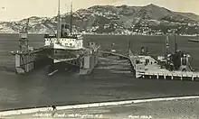
In 1928, the Harbour Board announced a decision to procure and install a floating dock with a lifting power of 15,000 tons, to be used for ship repairs.[71] The floating dock was built in England by Swan Hunter & Wigham Richardson of Wallsend,[72] with the contract awarded in August 1930 for a dock with a lifting capacity of 17,000 tons, with dimensions 540 ft (160 m) long and 117 ft (36 m) wide.[73] It left the Tyne on 15 July 1931 and was towed for five and a half months at sea over a route through the Suez Canal,[74] covering 13,000 mi (21,000 km),[75] and arrived in Wellington Harbour on 28 December 1931.[76] A wharf was built adjacent to the Thorndon reclamation for permanent mooring of the floating dock.[77][78] The dock was powered by electricity and included a crane capable of lifting up to five tons.[79] The dock was named 'Jubilee Dock' in honour of the Harbour Board's fiftieth anniversary in 1930.[80]
An initial test of the floating dock was undertaken with the passenger liner SS Ruahine, on 2 April 1932.[81] The first commercial service using the new floating dock was the overhaul of the ferry TSS Maori, from early April.[82][83]
One of the more notable incidents associated with the floating dock during more than 50 years of service was the repair of the trans-Tasman liner MS Wanganella after it struck Barrett Reef while entering Wellington Harbour in January 1947. Shortly after entering the floating dock, the repair work on the vessel was halted because of an industrial dispute.[84][85][86]
In 1988, the Harbour Board sold the floating dock to an engineering firm in Nelson, and it was then on-sold for use in Singapore. The dock was taken in tow from Wellington, but broke up and sank on 2 January 1989, only five days into the tow.[87]
Kaiwharawhara Wharf (proposed)
From the 1960s, state-owned roll on/roll off passenger ferries to Picton, currently branded as the Interislander, have berthed at a terminal near Aotea Quay. StraitNZ, a competing privately-owned company, operates its Bluebridge ferries from Glasgow Wharf. CentrePort Wellington, which manages shipping and other activities in the port of Wellington, proposes to build a new wharf at Kaiwharawhara for all passenger ferries.
Eastern side of Wellington Harbour

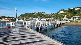
Day's Bay Wharf (1895)
Days Bay Wharf was built in 1895 by Neil McLean[88] for J. H. Williams to serve Williams' ferries bringing day-trippers from Wellington. Apart from benefitting day trippers, the wharf also improved access to bays on the eastern side of the harbour and this led to an increase in land values. In the early 20th century interest in Days Bay as an attraction decreased and in 1905 Williams sold his shares to the Miramar Ferry Company which then formed into Wellington Harbour Ferries. The ferry company's lease on the wharf expired in 1909 and Wellington Harbour Board took ownership.[89] Today the wharf is used by East by West Ferries to transport commuters and visitors, and is a popular attraction for people visiting the beach. Days Bay Wharf is listed as a Category 2 Historic Place by Heritage New Zealand.[90]
Rona Bay Wharf (1906)
Rona Bay Wharf was built for Wellington Harbour Board in 1906, with additions in 1908. The wharf has a bend in the middle. It was intended to serve passenger ferries and also ships bringing supplies to the fast-developing area. In fact, few ships other than ferries used the wharf, and the ferry service ended in 1948.[25] The Harbour Board then leased the wharf to the Eastbourne Borough Council (now Hutt City Council). In the 1990s, Hutt City Council considered demolishing the wharf but after public opposition a trust was created to look after the wharf.[91] After a restoration project costing $3.3 million, the wharf was re-opened in 2018.[91]
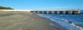
Petone Wharf (1909)
In 1883–1884 the Gear Meat Company built a wharf at Petone so that it could move its products quickly to Wellington for export.[92][93] The company bought an old ship, the Jubilee, and moored it at the wharf to use as a freezing plant.[94] When the ship was full it was towed across the harbour to Wellington and the meat transferred to other ships for transport to markets.[95] After Gear Meat's lease expired, the wharf was leased to the Petone Borough Council but still used by the company for shipping meat, coal, tallow and skins. The wharf deteriorated and was removed in 1902, and contractors for the Harbour Board built a new wharf slightly further east during 1908–1909.[96][97] The wharf has been used intermittently by passenger ferries.
Petone Wharf was popular with walkers and people fishing, but was closed to the public in January 2021 after suffering earthquake damage in the 2016 Kaikōura earthquake and two smaller subsequent earthquakes,[98][99] as well as damage from marine worms.[100] In May 2021, Hutt City Council voted to repair the wharf[101] but as of May 2022 was still considering the best course of action.[102] In November 2023, Hutt City councillors voted to demolish the wharf at a projected cost of $6 million. A local resident expressed concerns that demolishing the wharf would disturb the Waiwhetu Aquifer, but the Council states that the advice they have received from engineering consultants indicates that the aquifer will not be at risk if the wharf is removed.[100]
Point Howard Wharf (1930)
After Seaview was identified as a site for oil storage, the Texas Oil Company (Texaco and later Caltex) bought five acres in 1929 and built oil storage tanks. In the same year the Harbour Board started work on construction of a new oil wharf at Point Howard. The original wharf was made from hardwood logs and is 169m long.[25] As the wharf was not being used to offload general cargo it was designed with an approach that was only 14 ft (4.3 m) wide, much narrower than a normal wharf.[103] The wharf was completed in March 1930 and while limited numbers of tankers used the wharf initially, expansion of related industries in Seaview saw demand for the wharf increase. In 1933 the wharf was extended by adding a 159m-long tee-shape across the end.[25] In the 1970s Point Howard Wharf was replaced as an oil wharf by Seaview Wharf, and by the 1980s it was only used occasionally, by chemical tankers. After the disestablishment of Wellington Harbour Board in 1989, ownership of the wharf passed to Hutt City Council.
The tee at the end of the wharf was removed in late 2013 or early 2014 due to deterioration.[104]: 7 Point Howard Wharf was closed to visitors in 2018 after further damage to the piles was discovered.[105] Engineers have cautioned against demolition of the wharf because it is possible that disruption of the piles might cause major damage to the Waiwhetu Aquifer which supplies almost half of Wellington's fresh water.[25][104]: 10–11 As of July 2023 the wharf is still closed.
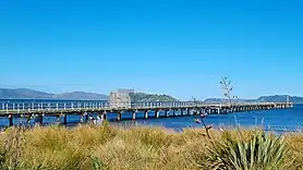
Seaview Wharf (1977)
Seaview Wharf at Point Howard, Seaview, is owned and maintained by CentrePort and serves a fuel terminal, replacing the older Point Howard Wharf. Planning for the construction of Seaview Wharf began in the mid-1960s,[106] and the wharf began operating in 1977.[107] The Seaview fuel terminal is the main point of supply for liquid fuels for the lower North Island, and is also a backup point of supply for other parts of the North Island. The landward end of the wharf is at Point Howard and it is approximately 600 m (2,000 ft) long.[107] Fuel pipelines along the wharf connect with bulk fuel storage facilities in Seaview. The fuel terminal handles approximately one million tonnes of fuel annually.[108]
In 2001, the wharf was equipped with an impressed current cathodic protection scheme to help prolong its life.[109] The wharf was damaged in the 2016 Kaikōura earthquake, but was able to continue operating.[110] A 2019 report published by the Wellington Lifelines Project included an observation that following a major earthquake:[111]: 31
Fuel is critical to run generators, earth-moving plant and for the transport of residents around the region. There will likely be significant roads outages preventing fuel tankers getting into the region, therefore a robust refuelling and storage facility for fuel is critical.
In 2021 a $60m project commenced to improve the seismic resilience of the wharf.[110][112]
Matiu / Somes island

In 1904, an early wharf at Somes Island was reported to be in poor condition.[113] The Minister of Public Works reported to Parliament in September 1908 that a new wharf had been erected at Somes Island.[114] The small wharf is now used by visitors to the island, including East by West ferries which has a regular service for tourists.
Evans Bay
Evans Bay Patent Slip (1873–1980)
A patent slip and associated jetty wharves were built in Evans Bay for servicing vessels of up to 2000 tons. The Patent Slip was commissioned in 1873. After over 100 years service, the slipway closed on 31 July 1980. The site was demolished and various equipment scrapped, sold or given to museums, and land was filled in for a new housing subdivision.[115][116] The site was listed as a Category 2 historic place in 1982.[117] Wellington City Council rezoned the site as a heritage area in 2003, and the area is now known as Cog Park.
Miramar Wharf (1901)
Miramar Wharf is situated on the Miramar Peninsula at the eastern head of Evans Bay. Miramar Wharf was funded by the Crawford family and built in 1901 by Neil McLean.[25][88] In 1909–1910 the wharf was altered and extended and at the same time a concrete seawall was built to the south and land reclaimed behind it.[118][119] Tram tracks were laid from the wharf through the newly-created Miramar Cutting to the Miramar Gas Works so that coal could be unloaded more efficiently.[25] The wharf was further lengthened in 1921. In November 2015 the wharf, now owned by CentrePort Wellington, was closed due to deterioration of the piles.[120]
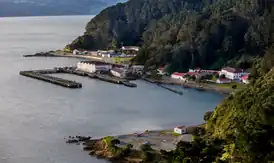
Shelly Bay Wharf (1902, 1940s)
In 1886, the Crown took over land at Shelly Bay for defence purposes and in the following years it became the site for an anti-submarine mine depot which included a wharf.[121][122] The wharf was extended in 1902.[123] In 1907, the base was transferred to the Royal Navy,[124] which constructed a new wharf. The wharf complex was expanded during World War II.[123] Ownership of the base including the wharf was transferred to the Royal New Zealand Navy after its creation in 1941, and then to the Royal New Zealand Air Force in 1946.[124] TEAL flying boats used the wharf in the 1950s.[123] The air force base closed in 1995 and since then parts of the wharf have rotted away through lack of maintenance.[125][124] Shelly Bay was the site of a proposed major residential development, but the project was cancelled in September 2023, and the land sold to Peter Jackson and Fran Walsh.[126]
Burnham Wharf (1927)
Burnham Wharf is an oil wharf located near Miramar Wharf at the head of Evans Bay. It was built for the British Imperial Oil Company and opened in 1927.[127] As of 2021 the wharf is operated by CentrePort. Aviation fuel for Wellington Airport arrives by ship to Burnham Wharf and is then piped to the airport.[128] The 2019 Wellington Lifelines Project reported that the wharf and the fuel infrastructure were reaching the end of their design lives, and were both vulnerable in an earthquake.[129]: 88
Flying boat jetty (1951)
A small jetty was built at Evans Bay in 1951 to serve a short-lived international flying boat service, at what is now Cog Park.[130]
In the months before the jetty was constructed, passengers were transported by launch between the shore and the flying boats, but in 1951 the jetty was built and connected via a gangway to a floating U-shaped pontoon made of 124 large square steel tanks connected together and ballasted with water and oil.[131] The pontoon was 110 ft long and 74 ft wide. The flying boat service to Australia ended in 1954,[132] and in 1957 the 400-ton pontoon structure, known as a 'Braby pontoon', was winched on to land, dismantled and transported in pieces to Auckland by road and rail, to be reused by the Air Force at Hobsonville Air Base.[133]
In November 2023, Wellington City Council announced that it intended to repair the jetty. The project would cost $500,000, but an anonymous donor had agreed to pay about half of that cost. Some city councillors raised concerns about the spending, given the Council's difficult financial position at the time of the announcement. The work is expected to begin in March 2024 and take several months, but may be delayed if nesting penguins are found at the site. Wellington City Council has asked the Department of Conservation for permission to relocate any penguins in the way of the project.[134] The jetty is not heritage-listed but the Council intends to give it some heritage protection after the repairs are completed.
Entrance to Wellington Harbour
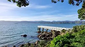
Seatoun Wharf (1901)
The Seatoun Roads Board was formed in 1880 to agitate for improved transport to Seatoun and promote development in the area. It helped build Seatoun Wharf, which opened in 1901.[25] The main part of the wharf is 67 m (220 ft) long and the end, which bends to the left, is 30.5 m (100 ft) long.[25] Ferries transported residents between Seatoun and Customhouse Quay in the city. Demand for travel by ferry collapsed after the Seatoun tunnel opened in 1908 and a tram service began, and the ferry service stopped in 1913. From the 1990s, East by West ferries ran a service in the harbour that sometimes included stops at Seatoun.[135] In 2021 Wellington City Council closed the wharf for 18 months for major repairs,[136] and when it reopened East by West Ferries stated that they would no longer offer a service to Seatoun.[137] The ferry company cited "increased running costs, passenger volumes, and scheduling issues" as the reason for the cancellation, saying that only one of their boats was able to berth at Seatoun in all tides.[137] Their new electric ferry was too large to use Seatoun Wharf.
Karaka Bay Wharf (1901)
Karaka Bay Wharf was built in 1901 by Neil McLean[88] for the Seatoun Roads Board, in an effort to encourage settlement in the area. Ferries took local people to and from the city, but after the Seatoun tunnel was built and trams came to the area, demand for the ferry decreased and the ferry stopped in 1913. Apart from a brief period in the 1920s when ferries ran again, the wharf has not been used since except by people fishing and swimming. The wharf used to be about twice as long as it is today, with a wide platform at the end.[138] In 2002 the remaining section was damaged in a storm and needed major repairs.[25] The wharf is managed by Wellington City Council.
See also
References
- 1 2 3 "Growth of a great port". Dominion. 11 January 1930. Retrieved 10 July 2023 – via Papers Past.
- ↑ "Harbour Board | NZETC". nzetc.victoria.ac.nz. Retrieved 12 June 2023.
- ↑ "Take notice! Extensive sale by auction [advertisement]". New Zealand Gazette and Wellington Spectator. 3 October 1840. Retrieved 10 July 2023 – via Papers Past.
- ↑ "Death of a pioneer settler, the late Mr J. J. Taine". Otago Witness. 30 September 1914. Retrieved 10 July 2023 – via Papers Past.
- ↑ "[untitled]". New Zealand Gazette and Wellington Spectator. 20 March 1841. Retrieved 19 June 2023 – via Papers Past.
- ↑ "Map" (PDF).
- ↑ "[untitled]". Oamaru Mail. 13 February 1878. Retrieved 19 June 2023 – via Papers Past.
- ↑ "[untitled]". New Zealand Mail. 3 February 1883. Retrieved 12 June 2023 – via Papers Past.
- ↑ "First-class hotel to let [advertisement]". Wellington Independent. 11 September 1858. Retrieved 10 July 2023 – via Papers Past.
- ↑ "[untitled]". Evening Post. 20 August 1920. Retrieved 12 June 2023 – via Papers Past.
- ↑ "Chamber of Commerce". Wellington Independent. 11 March 1859. Retrieved 10 July 2023 – via Papers Past.
- 1 2 3 4 The Wellington Harbour Board Collection. Wellington, New Zealand: Wellington Harbour Board. 1980. ISBN 0908582447.
- ↑ "A veteran's reminiscences". New Zealand Times. 31 December 1897. Retrieved 11 July 2023 – via Papers Past.
- 1 2 "Queens Wharf". Engineering New Zealand. Retrieved 10 July 2023.
- ↑ "Harbour Board Gates". wellingtoncityheritage.org.nz. 28 September 2017. Retrieved 10 July 2023.
- ↑ "The 1913 strike in Wellington". nzhistory.govt.nz. Retrieved 14 July 2023.
- ↑ "No more racehorses". New Zealand Times. 30 October 1913. Retrieved 15 July 2023 – via Papers Past.
- ↑ "Strikers harass free labourers". New Zealand Times. 25 October 1913. Retrieved 15 July 2023 – via Papers Past.
- ↑ O'Neil, Andrea (17 July 2015). "Wellington's Queens Wharf failed to fire – 150 years of news". Stuff. Retrieved 10 July 2023.
- ↑ "Shed 5". wellingtoncityheritage.org.nz. 20 December 2016. Retrieved 10 July 2023.
- ↑ "Shed 3". wellingtoncityheritage.org.nz. 20 December 2016. Retrieved 10 July 2023.
- 1 2 "'End of the line' for Hilton on waterfront". Stuff. 31 January 2009. Retrieved 21 July 2023.
- ↑ Green, Suzanne (10 February 2001). "Hilton's plan for queen's wharf". Evening Post. ProQuest 314737389.
- 1 2 3 "Cranes". Wellington City Council. 17 September 2020. Retrieved 10 July 2023.
- 1 2 3 4 5 6 7 8 9 10 11 12 13 14 15 16 17 18 19 20 21 22 Cochrane & Murray; Kelly, Michael; Dodd, Andy (30 June 2012). Coastal historic heritage of the Wellington Region: Survey for the coastal plan review [report] (PDF). Wellington, New Zealand: Greater Wellington Regional Council.
updated 31 October 2014
- ↑ Moor, Christopher (30 July 2009). "Remembering Paddy the Wanderer Tales of a unique dog". The Wellingtonian. Retrieved 13 June 2013.
- ↑ "[untitled]". Evening Post. 7 February 1879. Retrieved 17 July 2023 – via Papers Past.
- 1 2 3 4 5 6 7 8 9 10 11 Fill, Barbara; Astwood, Karen (16 March 2012). Registration Report for a Historic Area: Wellington Harbour Board Historic Area (Volume II) [report] (PDF). Wellington , New Zealand: New Zealand Historic Places Trust – via Greater Wellington Regional Council.
- ↑ "[untitled]". Evening Post. 13 April 1897. p. 5. Retrieved 19 July 2023 – via Papers Past.
Special attention is directed to the fact that from this date forward the steamers will leave the new Ferry Wharf at Waterloo-quay for the Bay in place of the Queen's Wharf.
- 1 2 "Eastbourne Ferry Terminal Building (Former)". www.wellingtoncityheritage.org.nz. 7 December 2017. Retrieved 19 July 2023.
- ↑ "Eastbourne Ferry Terminal Building (Former) and Ferry Wharf". Heritage New Zealand. Retrieved 19 July 2023.
- ↑ "Harbour Board". Evening Post. 17 November 1898 – via Papers Past.
- 1 2 "Wellington harbour accommodation". Evening Post. 24 January 1899. Retrieved 12 July 2023 – via Papers Past.
- ↑ "A port of the first class". Evening Post. 28 April 1899. Retrieved 12 July 2023 – via Papers Past.
- 1 2 3 "[untitled]". Evening Post. 18 November 1901. Retrieved 12 July 2023 – via Papers Past.
- ↑ "[untitled]". New Zealand Times. 5 March 1901. Retrieved 12 July 2023 – via Papers Past.
- 1 2 Glasgow Wharf (1901) [report] (PDF). Wellington: Greater Wellington Regional Council.
- ↑ "Taranaki Street Gates". wellingtoncityheritage.org.nz. 10 March 2017. Retrieved 18 July 2023.
- ↑ "Maheno roll-on reaches the Tasman run". Press. 28 May 1969. Retrieved 19 July 2023 – via Papers Past.
- ↑ Rennie, Jon (11 June 2013). "A perfect ten". Architecture Now. Retrieved 18 July 2023.
- ↑ "The King's Wharf". Dominion. 23 March 1909.
- ↑ "The King's Wharf". Wairarapa Daily Times. 26 March 1909 – via Papers Past.
- ↑ "H.M.S. New Zealand". Evening Post. 11 June 1913 – via Papers Past.
- ↑ "In the Evening". New Zealand Times. 24 October 1913 – via Papers Past.
- ↑ "The 1913 Great Strike – Outbreak of the 1913 strike". NZ History. Retrieved 18 July 2023.
- ↑ "US Forces in New Zealand – Arrival". NZ History. Retrieved 18 July 2023.
- ↑ "US Forces in NZ During 2nd World War". NZ Ship & Marine Society. Retrieved 18 July 2023.
- ↑ Heritage – King's Wharf (1909) – Inventory (PDF). 31 July 2018. Retrieved 18 July 2023 – via Greater Wellington Regional Council.
- ↑ Cubrinovski, Misko; Bray, Jonathan D.; de la Torre, Christopher; Olsen, Michael J.; Bradley, Brendon A.; Chiaro, Gabriele; Stocks, Emilia; Wotherspoon, Liam (June 2017). "Liquefaction effects and associated damages observed at the Wellington Centreport from the 2016 Kaikoura earthquake" (PDF). Bulletin of the New Zealand Society for Earthquake Engineering. 50 (2): 152–173. doi:10.5459/bnzsee.50.2.152-173. Archived (PDF) from the original on 27 May 2023. Retrieved 27 May 2023.
- ↑ "Wellington Harbour Board: Recent expenditure". Star. 28 January 1910 – via Papers Past.
- 1 2 3 4 "Clyde Quay Wharf and Apartments" (PDF). Greater Wellington Regional Council. May 2020. Retrieved 13 October 2021.
- 1 2 "Finished: Completion of the Clyde Quay Wharf". Dominion. 29 April 1910 – via Papers Past.
- ↑ "[untitled]". Otago Daily Times. 9 February 1910 – via Papers Past.
- ↑ "Ambitious plan for new sea terminal". Press. 5 July 1961 – via Papers Past.
- ↑ Gateway to New Zealand: Official Opening of Overseas Passenger Terminal. Wellington, New Zealand: Wellington Harbour Board. 1964 – via Wellington City Libraries.
- ↑ Schouten, Hank (27 April 2012). "Wellington Overseas Terminal almost gone". Stuff. Retrieved 13 October 2021.
- ↑ "Clyde Quay Wharf". Athfield Architects. Retrieved 13 October 2021.
- ↑ "[untitled]". Evening Post. 27 October 1911 – via Papers Past.
- ↑ "Extending the Ferry Wharf". New Zealand Times. 21 November 1911 – via Papers Past.
- 1 2 3 Harbour edge, Lambton Harbour [report] (PDF). [Wellington, New Zealand]: Greater Wellington Regional Council. May 2020.
- ↑ Hunt, Tom (12 October 2015). "Kumutoto development on Wellington waterfront gets green light". Stuff. Retrieved 20 July 2023.
- ↑ "Nga Kina". Wellington Sculpture Trust. Retrieved 20 July 2023.
- ↑ "Pipitea Pier – Our next work in wharves". Dominion. 1 October 1912 – via Papers Past.
- ↑ "Future of the port – Call for more wharfage". Evening Post. 25 May 1915 – via Papers Past.
- ↑ "Pipitea Wharf". Evening Post. 26 June 1919 – via Papers Past.
- ↑ "The last pile in new Pipitea Wharf". Dominion. 14 February 1923 – via Papers Past.
- ↑ "Cost of Pipitea Wharf – day labour cheaper". New Zealand Herald. 26 July 1923 – via Papers Past.
- ↑ "Wahine rams Wellington wharf". Evening Star. 6 June 1936 – via Papers Past.
- ↑ "General news". The Press. 7 May 1962 – via Papers Past.
- ↑ Misko Cubrinovski; Jonathan D. Bray; Christopher De La Torre; Michael J. Olsen; Brendon A. Bradley; Gabriele Chiaro; Emilia Stocks; Liam Wotherspoon (30 June 2017). "Liquefaction effects and associated damages observed at the Wellington CentrePort from the 2016 Kaikoura earthquake". Bulletin of the New Zealand Society for Earthquake Engineering. 50 (2): 152–173. doi:10.5459/BNZSEE.50.2.152-173. ISSN 1174-9857. Wikidata Q111719924.
- ↑ "Floating Dock – Harbour Board's decision". Dominion. 23 February 1928 – via Papers Past.
- ↑ "Wellington's Floating Dock". The Press. 16 October 1930 – via Papers Past.
- ↑ "Floating Dock – Wellington contract". New Zealand Herald. 18 August 1930 – via Papers Past.
- ↑ "Through Suez Canal – Jubilee Floating Dock". Dominion. 10 September 1931 – via Papers Past.
- ↑ "Wellington Gigantic Floating Dock at Sea". Timaru Herald. 29 December 1931 – via Papers Past.
- ↑ "Floating Dock Arrives". Dominion. 29 December 1931 – via Papers Past.
- ↑ "Where the floating dock will be moored". Wanganui Chronicle. 6 July 1931 – via Papers Past.
- ↑ "Floating Dock Wharf [photograph]". Wellington City Libraries. c. 1930. Retrieved 20 July 2023.
- ↑ "Wellington Harbour Board Official Hand Book". Wellington City Libraries. 1963. pp. 38–39. Retrieved 20 July 2023.
- ↑ "New Wellington dock". Sun (Auckland). 27 February 1930 – via Papers Past.
- ↑ "Testing the Jubilee Floating Dock". Dominion. 4 April 1932 – via Papers Past.
- ↑ "Wellington Jubilee Floating Dock: Earns its first money". Timaru Herald. 16 April 1932 – via Papers Past.
- ↑ "Maori enters the floating dock". Wanganui Chronicle. 7 April 1932 – via Papers Past.
- ↑ "Wanganella now in dock". Bay of Plenty Times. 19 February 1947 – via Papers Past.
- ↑ "When the Wanganella hit Barrett Reef". Evening Post. 18 January 1997. ProQuest 314501617.
- ↑ "Poor Wanganella ! Work halted yesterday". Evening Star. 21 February 1947 – via Papers Past.
- ↑ "Wellington's own pride and joy". Dominion Post. 19 November 2013. ProQuest 1459203187.
- 1 2 3 McLean, John (1966). "McLean, Neil". Retrieved 22 July 2023.
- ↑ McCracken, Helen (8 August 2001). "Days Bay Wharf". Welcome to Heritage New Zealand. Retrieved 10 July 2023.
- ↑ "Days Bay Wharf". Heritage New Zealand. Retrieved 21 July 2023.
- 1 2 Boyack, Nicholas (21 December 2018). "Fisherman steals the limelight at the opening of the Rona Bay wharf". Stuff. Retrieved 13 July 2023.
- ↑ "Petone Foreshore". www.huttcity.govt.nz. Hutt City Council. Retrieved 7 May 2020.
- ↑ Barnett, A. G. "Petone Wharf – Petone's First 100 Years (1940)". library.huttcity.mebooks.co.nz. Retrieved 22 March 2022.
- ↑ "[untitled]". New Zealand Mail. 1 February 1884. Retrieved 5 April 2022.
- ↑ "Our frozen meat trade". Evening Post. 27 January 1891. Retrieved 20 March 2022 – via Paperspast.
- ↑ "Wellington Harbour Board". New Zealand Mail. 5 March 1902. Retrieved 10 April 2022 – via Paperspast.
- ↑ "Petone wharf". The Dominion. 27 January 1909. Retrieved 10 April 2022 – via Paperspast.
- ↑ Council, Hutt City (1 July 2022). "Petone Wharf Rebuild". www.huttcity.govt.nz. Retrieved 15 December 2022.
- ↑ Tso, Matthew (18 January 2021). "Petone's 393m wharf closed after more earthquake damage found". Stuff. Retrieved 15 December 2022.
- 1 2 Boyack, Nicholas (22 November 2023). "Petone wharf to go but aquifer concerns linger". www.thepost.co.nz. Retrieved 22 November 2023.
- ↑ Keogh, Brittany (24 May 2021). "Hutt City Council moves ahead on $21m Petone Wharf repair, despite budget blow out worries". Stuff. Retrieved 15 December 2022.
- ↑ Calibre Consulting Ltd (19 May 2022). Petone Wharf future options [Report]. Wellington, New Zealand: Hutt City Council.
- ↑ For the New Oil Wharf, Evening Post, 2 November 1929, p. 10.
- 1 2 AC Consulting Group Ltd (February 1999). Report of future options for Point Howard Wharf [report]. Lower Hutt, New Zealand: Hutt City Council Leisure Services Division.
- ↑ Wenman, Eleanor (27 February 2018). "Lower Hutt wharf closed indefinitely for remedial work". Stuff. Retrieved 11 July 2023.
- ↑ "Wellington wharves: Major works proposed". The Press. 30 June 1967. Archived from the original on 27 May 2023. Retrieved 31 May 2023 – via Papers Past.
- 1 2 Lawson, Michael; Latham, Dean; Kooistra, Barry; Mandeno, Willie (2003), "Seaview Wharf: A Concrete CP Case Study", Coasts & Ports 2003 Australasian Conference: Proceedings of the 16th Australasian Coastal and Ocean Engineering Conference, the 9th Australasian Port and Harbour Conference and the Annual New Zealand Coastal Society Conference, Institution of Engineers, Australia: [1077]–[1086], ISBN 978-0-473-09832-2
- ↑ Juno, W.; Hall, L.; Delaney, A.; Terry, P. (2021). "Seaview Wharf: risk-based thinking underpins the future" (PDF). NZ Society for Earthquake Engineering. Archived (PDF) from the original on 27 May 2023. Retrieved 28 May 2023.
- ↑ "Switched on wharf". Dominion. 9 November 2001. ProQuest 315375921.
- 1 2 Tso, Matthew (27 June 2021). "$80m quake-resilience upgrade for lower North Island's fuel supply line in Lower Hutt". Stuff. Archived from the original on 27 May 2023. Retrieved 27 May 2023.
- ↑ "Protecting Wellington's Economy Through Accelerated Infrastructure Investment Programme Business Case" (PDF). Wellington Lifelines Group. 2019. Archived (PDF) from the original on 28 May 2023. Retrieved 28 May 2023.
- ↑ "What we do | Fletcher Construction". webcache.googleusercontent.com. Retrieved 11 July 2023.
- ↑ "General Telegrams". Evening Post. 23 September 1904 – via Papers Past.
- ↑ "Public Works Statement". Evening Star. 23 September 1908 – via Papers Past.
- ↑ "Evans Bay Patent Slip Area". www.wellingtoncityheritage.org.nz. Archived from the original on 7 October 2022. Retrieved 22 July 2021.
- ↑ McLean, Gavin (2013). "Evans Bay Patent Slip". nzhistory.govt.nz. Archived from the original on 6 October 2022. Retrieved 22 July 2021.
- ↑ "Evans Bay Patent Slip (Former)". Heritage New Zealand. Archived from the original on 16 March 2023. Retrieved 22 July 2021.
- ↑ "Harbour Works". Dominion. 17 June 1910. Retrieved 10 August 2021 – via Paperspast.
- ↑ "Inmagic DB/Text WebPublisher PRO: 1 records". www.aucklandcity.govt.nz. Retrieved 10 August 2021.
- ↑ "Miramar residents fear for future of Miramar Wharf after its closure last year". Stuff. 18 October 2016. Retrieved 10 August 2021.
- ↑ "Shelly Bay". Wellington City Council. 8 January 2020. Retrieved 8 January 2020.
- ↑ "Arrival of Major-General Edwards". Evening Post. 22 October 1889. Retrieved 13 July 2023 – via Papers Past.
The party [...] were landed at the wharf in Shelly Bay after a pleasant run of about 20 minutes.
- 1 2 3 Opus International Consultants (30 May 2019). Heritage Effects Assessment: 232, 264, 270 and 276 Shelly Bay Rd, Maupuia, Wellington [report]. Wellington, New Zealand: WSP Opus.
- 1 2 3 "Wellington's $500m Shelly Bay development granted resource consent". Stuff. 31 October 2019. Retrieved 20 July 2021.
- ↑ Jackman, Amy (27 February 2014). "Shelly Bay rotting away". Stuff. Retrieved 8 January 2020.
- ↑ Chin, Frances; Armah, Mildred (1 September 2023). "Shelly Bay sale to Peter Jackson and Fran Walsh bittersweet for mayor Tory Whanau". Stuff. Retrieved 1 September 2023.
- ↑ "The Oil Age". Evening Post. 26 January 1926. Retrieved 10 August 2021 – via Paperspast.
- ↑ "Centreport Annual Review 2018–2019 – Ferries & Fuel". 2019annualreport.centreport.co.nz. Retrieved 10 August 2021.
- ↑ "Protecting Wellington's Economy Through Accelerated Infrastructure Investment Programme Business Case" (PDF). Wellington Lifelines Group. 2019. Archived (PDF) from the original on 28 May 2023. Retrieved 28 May 2023.
- ↑ "Evans Bay flying-boat base". Press. 7 August 1951 – via Papers Past.
- ↑ "Flying boat pontoon". Press. 25 September 1951. p. 6 – via Papers Past.
- ↑ "More Evans Bay". theflyingboatforum.forumlaunch.net. 30 March 2014. Retrieved 13 November 2023.
- ↑ "Big moving contract". Press. 2 February 1957 – via Papers Past.
- ↑ Hunt, Tom (13 November 2023). "Wellington City to repair flying boat jetty amid financial woes". www.thepost.co.nz. Retrieved 13 November 2023.
- ↑ "Eastbourne ferry wins reprieve". Dominion. 26 July 1996. ProQuest 314927258.
- ↑ "Seatoun Wharf to close for TLC". Wellington City Council. 19 November 2020. Retrieved 15 July 2023.
- 1 2 Knell, Conor (24 January 2023). "'A total surprise': Councillor stunned by Days Bay to Seatoun ferry axing". Stuff. Retrieved 15 July 2023.
- ↑ "Karaka Bay Road, Karaka Bay, Wellington [photograph]". Auckland Libraries. Retrieved 15 July 2023.
External links
- Te Aro Reclamation No 1, locality plan, sheet 1 (1881) Map showing private wharves along Willis St that will be covered by proposed reclamation.
- General arrangement of wharves (1901) Map showing wharves and sheds in the inner harbour.
- Berthing map of Wellington Harbour (1970) Map showing wharves, reclamation in progress and numbered wharf sheds around the inner harbour.
- City Wharves (1978) Map showing inner harbour wharves
- Wellington's maritime heritage trail A Wellington City Council website detailing heritage sites to visit on a walk along the wharves and waterfront.