Western Region
ภาคตะวันตก | |
|---|---|
     From upper-left to lower-right: Khao Sam Roi Yot, Erawan Waterfall, Three Pagodas Pass, Srinagarind Dam and Hua Hin Beach | |
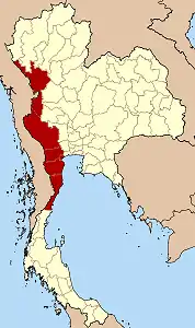 Western Region in Thailand | |
| Largest city | Hua Hin |
| Provinces | |
| Area | |
| • Total | 53,769 km2 (20,760 sq mi) |
| Population (2018) | |
| • Total | 3,430,314 |
| • Density | 64/km2 (170/sq mi) |
| GDP | |
| • Total | US$19.3 billion (2019) |
| Language | Thai • others |
Western Thailand is a region of Thailand bordering Myanmar on the west, Southern Thailand on the south, and central Thailand on the east.
Geography
Thailand's long mountainous border with Myanmar continues south from northern Thailand into western Thailand following the Tenasserim Hills. This narrow region stretches from Bangkok's outer reaches to the border with Myanmar and from the Shan Hills in the north to Chumphon Province in the south.
The geography of the western region is characterised by high mountains and steep river valleys. Western Thailand hosts much of Thailand's less-disturbed forest areas. Water and minerals are important natural resources. The region is home to many of the country's major dams, and mining is an important industry. Many village names in western Thailand rely heavily on the physical geography of the region.[2]
Provinces of western Thailand
According to the six geographical regions established by the National Research Council of Thailand, the western region includes the following provinces:
- Kanchanaburi (กาญจนบุรี)
- Phetchaburi (เพชรบุรี)
- Prachuap Khiri Khan (ประจวบคีรีขันธ์)
- Ratchaburi (ราชบุรี)
- Tak (ตาก)
Economy
For economic statistics of Western Thailand, Suphan Buri and Samut Songkhram provinces are listed by National Statistical Office (Thailand). However Tak Province is listed by (lower) Northern Thailand.
For FY 2018, Western Thailand Region had a combined economic output of 579.815 billion baht (US$18.7 billion), or 3.5 percent of Thailand's GDP. Ratchaburi province had an economic output of 189.68 billion baht (US$6.12 billion). This amounts to a GPP per capita of 233,258 baht (US$7,524), more than double for Suphan Buri province, lowest in the ranking.[3]
| Rank | Province | GPP (million baht) |
Population (x 1000) |
GPP per capita (baht) |
|---|---|---|---|---|
| 1 | Ratchaburi | 189,680 | 813 | 233,258 |
| 2 | Prachuap Khiri Khan | 93,381 | 488 | 191,306 |
| 3 | Phetchaburi | 72,035 | 499 | 144,392 |
| 4 | Samut Songkhram | 25,974 | 182 | 142,808 |
| 5 | Kanchanaburi | 107,144 | 829 | 129,304 |
| 6 | Suphan Buri | 91,602 | 854 | 107,228 |
| Western region | 579,815 | 3,665 | 158,206 |
Weather forecast
Kanchanaburi, Ratchaburi, Suphan Buri and Samut Songkhram provinces have been added to the central region by Thai Meteorological Department (TMD).
Petchaburi and Prachuap Khiri Khan provinces are part of the southern region (east coast).[4]
See also
References
- ↑ "Gross Regional and Provincial Product, 2019 Edition". <>. Office of the National Economic and Social Development Council (NESDC). July 2019. ISSN 1686-0799. Retrieved 22 January 2020.
- ↑ Surajitlak Deepadung, Toponyms in the Western Region of Thailand
- ↑ Phitsanulok Provincial Statistical Report 2562-2019: Economic Statistics - National Accounts. Phitsanulok Provincial Statistical Office (Report). National Statistical Office (NSO). 2020. p. 94. ISSN 1905-8314.
- ↑ "about us". Thai Meteorological department (TMD). 2021. Retrieved 26 February 2021.
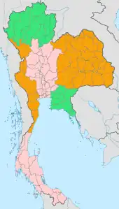 | Four-region division system |
| 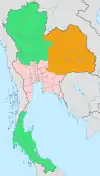 |
|---|---|---|---|
| Six-region division system |
| ||