Waitohu | |
|---|---|
Settlement | |
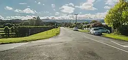 Waitohu Valley Road | |
| Coordinates: 40°45′32″S 175°10′01″E / 40.759°S 175.167°E | |
| Country | New Zealand |
| Region | Wellington Region |
| Territorial authority | Kāpiti Coast District |
| Ward | Ōtaki Ward |
| Community | Ōtaki Community |
| Electorates | |
| Government | |
| • Territorial Authority | Kāpiti Coast District Council |
| • Regional council | Greater Wellington Regional Council |
| • Kāpiti Coast Mayor | Janet Holborow |
| • Ōtaki MP | Tim Costley |
| • Te Tai Hauāuru MP | Debbie Ngarewa-Packer |
| Area | |
| • Total | 0.74 km2 (0.29 sq mi) |
| Population (June 2022)[2] | |
| • Total | 1,150 |
| • Density | 1,600/km2 (4,000/sq mi) |
Waitohu is a settlement in the Kāpiti Coast District of the Wellington Region of New Zealand's North Island. It is located east of Ōtaki, separated by the North Island Main Trunk railway line. Waitohu Valley Road runs southeast from State Highway 1 along the Waitohu Stream, and then leaves the stream and turns northeast.[3]
Demographics
Waitohu covers 0.74 km2 (0.29 sq mi).[1] It had an estimated population of 1,150 as of June 2022, with a population density of 1,554.05 people per km2.
| Year | Pop. | ±% p.a. |
|---|---|---|
| 2006 | 813 | — |
| 2013 | 927 | +1.89% |
| 2018 | 1,011 | +1.75% |
| Source: [4] | ||
Waitohu had a population of 1,011 at the 2018 New Zealand census, an increase of 84 people (9.1%) since the 2013 census, and an increase of 198 people (24.4%) since the 2006 census. There were 396 households, comprising 471 males and 540 females, giving a sex ratio of 0.87 males per female. The median age was 47.0 years (compared with 37.4 years nationally), with 174 people (17.2%) aged under 15 years, 159 (15.7%) aged 15 to 29, 405 (40.1%) aged 30 to 64, and 270 (26.7%) aged 65 or older.
Ethnicities were 77.2% European/Pākehā, 28.8% Māori, 3.0% Pasifika, 5.6% Asian, and 1.8% other ethnicities. People may identify with more than one ethnicity.
The percentage of people born overseas was 15.1, compared with 27.1% nationally.
Although some people chose not to answer the census's question about religious affiliation, 49.3% had no religion, 38.6% were Christian, 0.3% had Māori religious beliefs, 0.6% were Hindu, 0.3% were Muslim, 0.6% were Buddhist and 1.5% had other religions.
Of those at least 15 years old, 141 (16.8%) people had a bachelor's or higher degree, and 195 (23.3%) people had no formal qualifications. The median income was $26,600, compared with $31,800 nationally. 96 people (11.5%) earned over $70,000 compared to 17.2% nationally. The employment status of those at least 15 was that 336 (40.1%) people were employed full-time, 147 (17.6%) were part-time, and 27 (3.2%) were unemployed.[4]
Education
Waitohu School is a co-educational state primary school for Year 1 to 6 students[5][6] with a roll of 249 as of April 2023.[7] The school opened in 1963.[8]
References
- 1 2 "ArcGIS Web Application". statsnz.maps.arcgis.com. Retrieved 20 May 2021.
- ↑ "Population estimate tables - NZ.Stat". Statistics New Zealand. Retrieved 25 October 2022.
- ↑ Waitohu Stream, Wellington (Map).
- 1 2 "Statistical area 1 dataset for 2018 Census". Statistics New Zealand. March 2020. Waitohu (236700). 2018 Census place summary: Waitohu
- ↑ "Waitohu School Official School Website". waitohu.school.nz.
- ↑ "Waitohu School Ministry of Education School Profile". educationcounts.govt.nz. Ministry of Education.
- ↑ "Waitohu School Education Review Office Report". ero.govt.nz. Education Review Office.
- ↑ 2013 Jubilee Committee (2013). Waitohu School - Celebrating 50 Years 1963–2013 (PDF).
{{cite book}}: CS1 maint: numeric names: authors list (link)