Van Cleave, Kentucky | |
|---|---|
 Van Cleave  Van Cleave | |
| Coordinates: 36°39′16.2″N 88°14′20.13″W / 36.654500°N 88.2389250°W | |
| Country | United States |
| State | Kentucky |
| County | Calloway |
| Elevation | 541 ft (165 m) |
| Time zone | UTC-6 (Central (CST)) |
| • Summer (DST) | UTC-5 (CDT) |
| Area code(s) | 270 & 364 |
| GNIS feature ID | 509271[1] |
Van Cleave is an unincorporated community in Calloway County, Kentucky United States. The community is centered around the intersection of Van Cleave Road, Elm Grove Road and Todd Road just north of Kentucky Route 80.[1]
The community had a post office from February 7, 1895 to October 14, 1905.[2]
References
Municipalities and communities of Calloway County, Kentucky, United States | ||
|---|---|---|
| Cities | 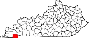 Location of Calloway County, Kentucky | |
| CDP | ||
| Unincorporated communities | ||
This article is issued from Wikipedia. The text is licensed under Creative Commons - Attribution - Sharealike. Additional terms may apply for the media files.