Vápenná | |
|---|---|
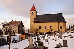 Church of Saint Philip | |
 Flag  Coat of arms | |
 Vápenná Location in the Czech Republic | |
| Coordinates: 50°17′0″N 17°5′52″E / 50.28333°N 17.09778°E | |
| Country | |
| Region | Olomouc |
| District | Jeseník |
| First mentioned | 1358 |
| Area | |
| • Total | 36.79 km2 (14.20 sq mi) |
| Elevation | 408 m (1,339 ft) |
| Population (2023-01-01)[1] | |
| • Total | 1,187 |
| • Density | 32/km2 (84/sq mi) |
| Time zone | UTC+1 (CET) |
| • Summer (DST) | UTC+2 (CEST) |
| Postal code | 790 64 |
| Website | www |
Vápenná (until 1949 Zighartice; German: Setzdorf) is a municipality and village in Jeseník District in the Olomouc Region of the Czech Republic. It has about 1,200 inhabitants.
Vápenná lies approximately 9 kilometres (6 mi) north-west of Jeseník, 77 km (48 mi) north of Olomouc, and 193 km (120 mi) east of Prague.
Administrative parts
The hamlet of Polka is an administrative part of Vápenná.
History
The first written mention of Zighartice is from 1358. The village was abandoned in around 1420, but was resettled in 1576.[2]
During the World War II, the German occupiers operated four forced labour subcamps of the Stalag VIII-B/344 prisoner-of-war camp at the local quarries.[3]
In 1949, the municipality was renamed Vápenná.[2]
Notable people
- Emil Beier (1893–1985), Nazi German politician
References
- ↑ "Population of Municipalities – 1 January 2023". Czech Statistical Office. 2023-05-23.
- 1 2 "Historie" (in Czech). Obec Vápenná. Retrieved 2022-01-24.
- ↑ "Working Parties". Lamsdorf.com. Archived from the original on 29 October 2020. Retrieved 12 November 2021.
External links
Wikimedia Commons has media related to Vápenná.
This article is issued from Wikipedia. The text is licensed under Creative Commons - Attribution - Sharealike. Additional terms may apply for the media files.