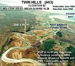
Twin Hills Airport | |||||||||||
|---|---|---|---|---|---|---|---|---|---|---|---|
 | |||||||||||
| Summary | |||||||||||
| Airport type | Public | ||||||||||
| Owner | State of Alaska DOT&PF - Central Region | ||||||||||
| Serves | Twin Hills, Alaska | ||||||||||
| Elevation AMSL | 82 ft / 25 m | ||||||||||
| Coordinates | 59°04′28″N 160°16′30″W / 59.07444°N 160.27500°W | ||||||||||
| Map | |||||||||||
 TWA Location of airport in Alaska | |||||||||||
| Runways | |||||||||||
| |||||||||||
| Statistics (2009) | |||||||||||
| |||||||||||
Twin Hills Airport (IATA: TWA, FAA LID: A63) is a state-owned, public-use airport serving Twin Hills,[1] in the Dillingham Census Area of the U.S. state of Alaska. Scheduled airline service to Dillingham Airport is provided by Peninsula Airways (PenAir).[3]
As per Federal Aviation Administration records, this airport had 395 commercial passenger boardings (enplanements) in calendar year 2008, a decrease of 23% from the 510 enplanements in 2007.[2] Twin Hills Airport is included in the FAA's National Plan of Integrated Airport Systems (2009–2013), which categorizes it as a general aviation facility.[4]
Although most U.S. airports use the same three-letter location identifier for the FAA and IATA, this airport is assigned A63 by the FAA and TWA by the IATA.[5]
Facilities and aircraft
Twin Hills Airport has one runway designated 18/36 with a gravel surface measuring 3,000 by 60 feet (914 x 18 m). For the 12-month period ending February 28, 2009, the airport had 1,900 aircraft operations, an average of 158 per month: 87% air taxi and 13% general aviation.[1]
Airlines and destinations
| Airlines | Destinations |
|---|---|
| Grant Aviation | Dillingham, Manokotak, Togiak[6] |
See also
References
- 1 2 3 FAA Airport Form 5010 for A63 PDF. Federal Aviation Administration. effective 27 Aug 2009.
- 1 2 CY 2008 Passenger Boarding and All-Cargo Data (Preliminary). Federal Aviation Administration. Published 15 July 2009.
- ↑ 2009 Timetables Archived 2008-12-22 at the Wayback Machine. Peninsula Airways. Retrieved 6 Sep 2009.
- ↑ FAA National Plan of Integrated Airport Systems: 2009-2013. Federal Aviation Administration. Published 1 Oct 2008.
- ↑ Great Circle Mapper: TWA - Twin Hills, Alaska. Retrieved 6 Sep 2009.
- ↑ "Grant Schedule". (retrieved Sep 11, 2022)
External links
- FAA Alaska airport diagram (GIF)
- Resources for this airport:
- FAA airport information for A63
- AirNav airport information for A63
- ASN accident history for TWA
- FlightAware airport information and live flight tracker
- SkyVector aeronautical chart for A63