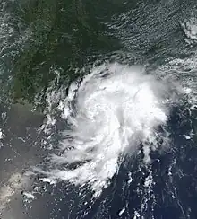
 Bertha shortly before classification as a tropical depression on August 4 | |
| Meteorological history | |
|---|---|
| Formed | August 4, 2002 |
| Dissipated | August 9, 2002 |
| Tropical storm | |
| 1-minute sustained (SSHWS/NWS) | |
| Highest winds | 40 mph (65 km/h) |
| Lowest pressure | 1007 mbar (hPa); 29.74 inHg |
| Overall effects | |
| Fatalities | 1 direct |
| Damage | $200,000 (2002 USD) |
| Areas affected | Florida, Alabama, Mississippi, Louisiana, Texas |
| IBTrACS | |
Part of the 2002 Atlantic hurricane season | |
Tropical Storm Bertha was a minimal tropical storm that made landfall twice along the Gulf Coast of the United States in August 2002. The second tropical storm of the 2002 Atlantic hurricane season, Bertha developed in the northern Gulf of Mexico out of a trough of low pressure that extended into the Atlantic on August 4. It quickly organized and reached tropical storm strength before making landfall on southeastern Louisiana. Bertha turned to the southwest over the state, and re-entered the Gulf of Mexico on August 7. It remained disorganized due to proximity to land, and after making landfall on south Texas, Bertha dissipated on August 9.
Bertha was one of only three tropical cyclones to make landfall on both Louisiana and Texas; the others being Allison in 2001 and Fern in 1971.[1] Heavy surf killed one person in Florida. The storm dropped moderate amounts of rainfall along its path, peaking at over 10 inches (250 mm) in eastern Louisiana and southern Mississippi. Damage was light, totaling to only $200,000 (2002 USD, $240,000 2008 USD).
Meteorological history

Tropical storm (39–73 mph, 63–118 km/h)
Category 1 (74–95 mph, 119–153 km/h)
Category 2 (96–110 mph, 154–177 km/h)
Category 3 (111–129 mph, 178–208 km/h)
Category 4 (130–156 mph, 209–251 km/h)
Category 5 (≥157 mph, ≥252 km/h)
Unknown
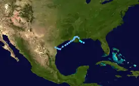
A non-tropical trough at the surface extended from the northern Gulf of Mexico across Florida into the western Atlantic Ocean. On August 3, the western portion developed into a low pressure area. The eastern portion slowly organized and ultimately developed into Tropical Storm Cristobal. The low pressure area in the Gulf of Mexico steadily organized,[2] and late on August 4 the circulation was organized enough for the National Hurricane Center to classify it as Tropical Depression Two while located 40 miles (64 km) east of Port Eads, Louisiana. Northeasterly wind shear initially prevented organization of the cloud pattern,[3] though the depression was able to strengthen to become Tropical Storm Bertha about five hours after it formed.[2]
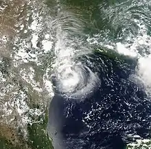
Outflow became much better organized as Bertha became a tropical storm, and well-defined banding features persisted to the north of the storm. Though convection waned, forecasters predicted the friction between land and the warm atmosphere to redevelop more deep convection, potentially resulting in further strengthening.[4] However, the storm failed to intensify, and Bertha made landfall near Boothville, Louisiana as a minimal tropical storm early on August 5. It slowly weakened over the swampy portions of southeastern Louisiana, and degenerated to a tropical depression later on the 5th after crossing Lake Pontchartrain.[2] Initially it was expected that a ridge of high pressure to its north would keep Bertha moving to the west and result in it slowly dissipating.[5] However, it turned to the southwest, and reached the Gulf of Mexico again on August 7.[2] The circulation persisted over land, and Tropical Depression Bertha quickly redeveloped convection. Though the environment was not unfavorable, its proximity to land prevented re-strengthening to tropical storm status.[6] Though the system showed periods of increased organization as it moved southwestward, Bertha remained a weak tropical depression until making landfall on south Texas to the east of Kingsville on August 9. Bertha weakened quickly over land, and dissipated over southern Texas ten hours after making landfall.[2]
Preparations

The National Hurricane Center issued a tropical storm warning from Pascagoula, Mississippi to the mouth of the Mississippi River as Bertha became a tropical storm. The warning occurred 90 minutes before the storm made landfall. All warnings were discontinued when Bertha weakened to a tropical depression over Louisiana. No watches or warnings were required for Texas, due to the improbability of it re-intensifying.[2]
The National Weather Service advised boats along the Gulf coast to remain at port. The service also issued a coastal flood watch from Alabama through the Florida Panhandle.[7] A flood watch was issued for portions of eastern Louisiana and southwestern Mississippi.[8]
Impact

The area of low pressure preceding the development of Bertha produced rough surf and rip currents along the Florida coastline. In Perdido Key State Recreation Area,[2] two children were swimming in an unguarded area when they were swept away by the currents. Their grandfather attempted to rescue them, but drowned in the rough waters. Another family rescued the two children.[9] The large circulation of Bertha produced light rainfall across Florida,[10] with Pensacola and Destin reporting 2.75 inches.[11] Extreme southern portions of Alabama received over 3 inches (76 mm) of rain from the storm, while western Dauphin Island reported over 5 inches (130 mm).[10]
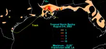
Upon making landfall, Waveland, Mississippi recorded a peak storm surge of 4.12 feet (1.26 m). Sustained winds there peaked at 31 mph (50 km/h), and a peak gust of 41 mph (66 km/h). Tropical Storm Bertha produced moderate to heavy precipitation across southern Mississippi, including a total of 10.25 inches (260 mm) in Pascagoula.[2] In Moss Point, the rainfall resulted in flooding which entered 15 to 20 houses and several cars. The rainfall also flooded roadways and streets. Damage in Mississippi totaled to $50,000 (2002 USD, $60,000 2008 USD).[12]
The storm dropped heavy rainfall in Louisiana, which peaked at 10.25 inches in Norwood. Storm tides were generally 1 to 2 feet (0.30 to 0.61 m) above normal, while the mouth of the Bayou Dupre recorded a storm tide of 3.79 feet (1.16 m).[2] The rainfall led to flash flooding in places, and also a few overflowed rivers in St. Tammany Parish.[13] The flooding covered several roadways[14] and bridges, and entered a few businesses and houses in East Feliciana Parish.[15] Damage in Louisiana totaled to $150,000 (2002 USD, $180,000 2008 USD).[13][14][15][16]
In Texas, Bertha produced a storm tide of 3 feet (0.91 m) at Baffin Bay.[17] Only light rainfall occurred in the state, with a few isolated areas receiving over 1 inch (25 mm) of precipitation.[10]
See also
References
- ↑ Hurricane Research Division (2006). "Hurdat Data for Tropical Cyclones 1851-2005". NOAA. Archived from the original on July 5, 2006. Retrieved 2006-10-23.
- 1 2 3 4 5 6 7 8 9 Jack Beven (2002). "Tropical Storm Bertha Tropical Cyclone Report" (PDF). National Hurricane Center. Retrieved 2015-05-26.
- ↑ Lawrence (2002). "Tropical Depression Two Discussion One". NHC. Retrieved 2006-10-23.
- ↑ Stewart (2002). "Tropical Storm Bertha Discussion Two". NHC. Retrieved 2006-10-23.
- ↑ Beven (2002). "Tropical Depression Bertha Discussion Five". NHC. Retrieved 2006-10-23.
- ↑ Avila (2002). "Tropical Depression Bertha Discussion Thirteen". NHC. Retrieved 2006-10-23.
- ↑ National Oceanic and Atmospheric Administration (2002). "Tropical Storm Bertha moving over Southeast Louisiana". Retrieved 2006-10-23.
- ↑ New Orleans National Weather Service (2002). "Flash Flood Watch Bulletin". Retrieved 2006-10-23.
- ↑ National Climatic Data Center (2002). "Event Report for Florida". Archived from the original on 2011-05-19. Retrieved 2006-10-23.
- 1 2 3 David Roth (2002). "Rainfall Data for Tropical Storm Bertha". Hydrometeorological Prediction Center. Retrieved 2006-10-23.
- ↑ Kells & Roth (2002). "Tropical Depression Bertha Tropical Summary Six". HPC. Archived from the original on October 8, 2006. Retrieved 2006-10-23.
- ↑ NCDC (2002). "Event Report for Mississippi". Retrieved 2006-10-23.
- 1 2 NCDC (2002). "Event Report for Louisiana". Retrieved 2006-10-23.
- 1 2 NCDC (2002). "Event Report for Louisiana (2)". Retrieved 2006-10-23.
- 1 2 NCDC (2002). "Event Report for Louisiana (3)". Retrieved 2006-10-23.
- ↑ NCDC (2002). "Event Report for Louisiana (4)". Retrieved 2006-10-23.
- ↑ Jamaica Beach Weather Observatory (2005). "Tropical Storms and Hurricane Statistics". Retrieved 2006-10-23.
