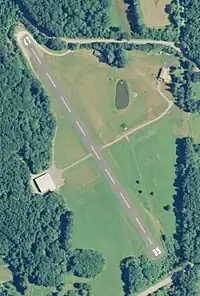
Toutant Airport | |||||||||||
|---|---|---|---|---|---|---|---|---|---|---|---|
 USGS 2006 orthophoto | |||||||||||
| Summary | |||||||||||
| Airport type | Public | ||||||||||
| Owner | Roland J. Toutant | ||||||||||
| Operator | Roland J. Toutant | ||||||||||
| Serves | Putnam | ||||||||||
| Location | |||||||||||
| Elevation AMSL | 770 ft / 235 m | ||||||||||
| Coordinates | 41°57′20″N 72°3′15″W / 41.95556°N 72.05417°W | ||||||||||
| Map | |||||||||||
| Runways | |||||||||||
| |||||||||||
| Statistics (2009) | |||||||||||
| |||||||||||
Toutant Airport (FAA LID: C44), is located in Woodstock, Connecticut, United States.
Facilities and aircraft
Toutant Airport is situated six miles northwest of the central business district of Putnam, Connecticut, and contains one runway. The runway, 17/35, is asphalt measuring 1756 x 60 ft (535 x 18 m).
For the 12-month period ending April 30, 2015, the airport had 200 aircraft operations, an average of 200 per year: 40% local general aviation, and 60% transient general aviation. At that time there were 4 aircraft based at this airport: 25% single-engine, 50% helicopter, and 25% ultralight.[2]
See also
References
- ↑ FAA Airport Form 5010 for C44 PDF, effective 2010-11-18
- ↑ AirNav: C44 - Toutant Airport
This article is issued from Wikipedia. The text is licensed under Creative Commons - Attribution - Sharealike. Additional terms may apply for the media files.