| Tidan | |
|---|---|
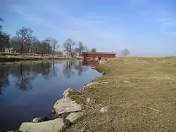
 Historical covered bridge | |
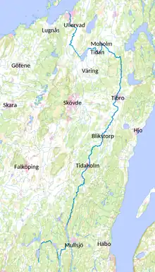
 Course of Tidan running north | |
| Location | |
| Country | Sweden |
| County | Västra Götaland County |
| Physical characteristics | |
| Mouth | Vänern |
• location | Mariestad, Västra Götaland County |
• coordinates | 58°42′50″N 13°49′00″E / 58.71389°N 13.81667°E |
• elevation | 44 m (144 ft) |
| Length | 140 km (87 mi)[1] |
| Basin size | 2,230 km2 (860 sq mi)[1] |
| Discharge | |
| • average | 20 m3/s (710 cu ft/s)[1] |
Tidan is a river in Sweden. It is one of few Swedish rivers that flow north. The river can be canoed from Bottnaryd (57°46′21″N 13°50′33″E / +57.7724°N +13.8426°E) to Mariestad (58°41′32″N 13°49′30″E / +58.6921°N +13.8249°E), a trip that takes 7–10 days.
Gallery
 Canoe portage on the Tidan River using timber skids, nearby to road bridge F1838
 Tidan River in Ettaks strömmar nature reserve, looking upstream with service bridge in background
 Tidan River looking upstream from east bank in Ettaks strömmar nature reserve
 Canoeing the Tidan River near Lagerfors
 Historic covered bridge on the Tidan River
 Cows grazing on banks of the Tidan River, within the bounds of the Östens naturreservat
 Lake Östen, a nature reserve in Sweden, looking approximately west
 Lake Östen, a nature reserve on the Tidan River
References
- 1 2 3 "Tidan". Nationalencyklopedin (in Swedish). Retrieved 16 July 2010. (subscription required)
This article is issued from Wikipedia. The text is licensed under Creative Commons - Attribution - Sharealike. Additional terms may apply for the media files.