Te Hana | |
|---|---|
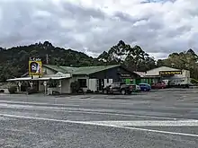
 Te Hana community hall | |
| Coordinates: 36°15′25″S 174°30′29″E / 36.257°S 174.508°E | |
| Country | New Zealand |
| Region | Auckland Region |
| Ward | Rodney ward |
| Community board | Rodney Local Board |
| Electorates | |
| Government | |
| • Territorial Authority | Auckland Council |
| Area | |
| • Total | 0.76 km2 (0.29 sq mi) |
| Population (June 2023)[2] | |
| • Total | 120 |
| • Density | 160/km2 (410/sq mi) |
Te Hana is a small town on State Highway 1 near the northern boundary of Auckland. Wellsford is 5 km (3.1 mi) to the south, and Kaiwaka is 15 km (9.3 mi) northeast. Te Hana Creek runs westward on the northern end of the town to the Kaipara Harbour.[3]
History
The town gained a post office in 1871.[4] A school flourished in Te Hana in the early 20th century.[5][6]
The Port Albert Co-operative Dairy Company replaced its factory in Port Albert with a more substantial one in Te Hana in 1934.[7] The dairy factory was the town's major employer until it closed in 1987.[8] After it closed Te Hana declined, with a high crime rate, unemployment of 20%, significant substance abuse, and poor living conditions.[9]
.jpg.webp)
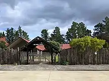
Te Hana Community Charitable Development Trust was formed in 2002 to rejuvenate the town, with one of its major initiatives a Māori cultural centre to attract tourists with a recreation of a pre-European Māori village.[9][10]
Demographics
| Year | Pop. | ±% p.a. |
|---|---|---|
| 2006 | 102 | — |
| 2013 | 96 | −0.86% |
| 2018 | 105 | +1.81% |
| Source: [11] | ||
Statistics New Zealand describes Te Hana as a rural settlement, which covers 0.76 km2 (0.29 sq mi)[1] and had an estimated population of 120 as of June 2023,[2] with a population density of 158 people per km2. Te Hana is part of the larger Okahukura Peninsula statistical area.[12]
Te Hana had a population of 105 at the 2018 New Zealand census, an increase of 9 people (9.4%) since the 2013 census, and an increase of 3 people (2.9%) since the 2006 census. There were 33 households, comprising 54 males and 54 females, giving a sex ratio of 1.0 males per female. The median age was 34.9 years (compared with 37.4 years nationally), with 27 people (25.7%) aged under 15 years, 18 (17.1%) aged 15 to 29, 57 (54.3%) aged 30 to 64, and 6 (5.7%) aged 65 or older.
Ethnicities were 65.7% European/Pākehā, 34.3% Māori, 2.9% Pacific peoples, 11.4% Asian, and 2.9% other ethnicities. People may identify with more than one ethnicity.
Although some people chose not to answer the census's question about religious affiliation, 45.7% had no religion, 40.0% were Christian, 5.7% were Hindu and 2.9% had Māori religious beliefs.
Of those at least 15 years old, 6 (7.7%) people had a bachelor's or higher degree, and 15 (19.2%) people had no formal qualifications. The median income was $32,000, compared with $31,800 nationally. 3 people (3.8%) earned over $70,000 compared to 17.2% nationally. The employment status of those at least 15 was that 51 (65.4%) people were employed full-time, 6 (7.7%) were part-time, and 9 (11.5%) were unemployed.[11]
References
- 1 2 "ArcGIS Web Application". statsnz.maps.arcgis.com. Retrieved 12 May 2022.
- 1 2 "Subnational population estimates (RC, SA2), by age and sex, at 30 June 1996-2023 (2023 boundaries)". Statistics New Zealand. Retrieved 25 October 2023. (regional councils); "Subnational population estimates (TA, SA2), by age and sex, at 30 June 1996-2023 (2023 boundaries)". Statistics New Zealand. Retrieved 25 October 2023. (territorial authorities); "Subnational population estimates (urban rural), by age and sex, at 30 June 1996-2023 (2023 boundaries)". Statistics New Zealand. Retrieved 25 October 2023. (urban areas)
- ↑ Harriss, Gavin (March 2022). Te Hana, Auckland (Map). NZ Topo Map.
- ↑ "Chief Post Office". Auckland Star. 20 June 1871.
- ↑ "Auckland Education Board". Auckland Star. 27 September 1911.
- ↑ "Peter pan's post box". Waikato Times. 20 April 1929.
- ↑ "Local & General". Northern Advocate. 9 April 1934.
- ↑ "The former Albertland Co-Operative Dairy Company Building at Te Hana (1934)". Back Roads. 11 October 2013.
- 1 2 Kilgallon, Steve (31 July 2011). "Te Hana – The Answer". Sunday Star-Times.
- ↑ Wright, Danielle (5 July 2011). "Cultural village puts Te Hana back on the map". New Zealand Herald.
- 1 2 "Statistical area 1 dataset for 2018 Census". Statistics New Zealand. March 2020. 7001181.
- ↑ 2018 Census place summary: Okahukura Peninsula