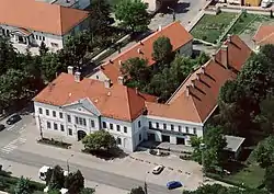
Szabadszállás | |
|---|---|
 Aerial view | |
 Flag  Coat of arms | |
 Szabadszállás | |
| Coordinates: 46°52′N 19°13′E / 46.867°N 19.217°E | |
| Country | |
| County | Bács-Kiskun |
| District | Kunszentmiklós |
| Area | |
| • Total | 164.62 km2 (63.56 sq mi) |
| Population (2015) | |
| • Total | 6,148 |
| • Density | 37/km2 (97/sq mi) |
| Time zone | UTC+1 (CET) |
| • Summer (DST) | UTC+2 (CEST) |
| Postal code | 6080 |
| Area code | (+36) 76 |
| Website | www |
Szabadszállás is a small town in Bács-Kiskun county, Hungary, 80 kilometres south of Budapest by rail. The town is surrounded by several areas of the Kiskunság National Park.
Twin cities
Gallery
References
External links
Wikimedia Commons has media related to Szabadszállás.
- Official website in Hungarian
- Szabadszállás on Google Maps
- (in Hungarian) Szabadszállás a Vendégvárón
- (in Hungarian) Szabadszállás a Gyaloglón
- (in Hungarian) Légifotók Szabadszállásról
46°52′N 19°13′E / 46.867°N 19.217°E
This article is issued from Wikipedia. The text is licensed under Creative Commons - Attribution - Sharealike. Additional terms may apply for the media files.


