50°47′0.51″N 0°3′26.1″E / 50.7834750°N 0.057250°E
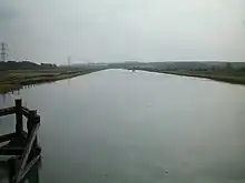
A southward view from Southease swing bridge with the trail on the right bank of the river
The Sussex Ouse Valley Way is a 42–mile long-distance footpath which closely follows the route of the Sussex Ouse. It starts at the Ouse's source in Lower Beeding, West Sussex, when it's still a little stream.[1] It then passes through many villages and towns including Slaugham, Handcross, Staplefield, and Lewes. It terminates at Seaford on the English Channel, where it joins the Vanguard Way.[2][3]
References
- ↑ The Meresman. An East Sussex County Council publication. (pdf.) Retrieved 2009-09-24
- ↑ "The Sussex Ouse Valley Way (low-res route map and description)" (PDF). West Sussex County Council. Retrieved 24 September 2009.
- ↑ Grid reference TQ 4598 0028
External links
 Media related to Sussex Ouse Valley Way at Wikimedia Commons
This article is issued from Wikipedia. The text is licensed under Creative Commons - Attribution - Sharealike. Additional terms may apply for the media files.