Subang Regency
Kabupaten Subang | |
|---|---|
| Other transcription(s) | |
| • Sundanese | ᮊᮘᮥᮕᮒᮦᮔ᮪ ᮞᮥᮘᮀ |
 Coat of arms | |
| Motto(s): Karya Utama Satya Nagara (Prioritizing Works for the Sake of the Country) | |
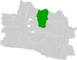 Location in West Java | |
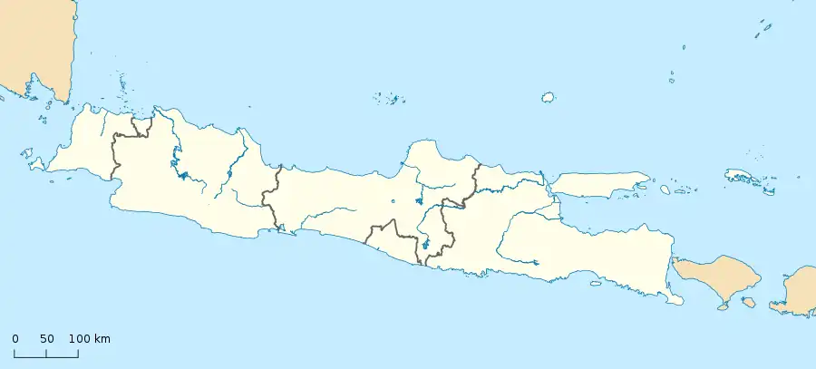 Subang Regency Location in Java Island and Indonesia 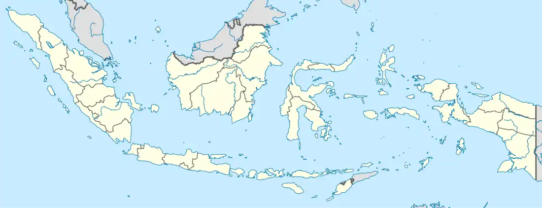 Subang Regency Subang Regency (Indonesia) | |
| Coordinates: 6°34′16″S 107°45′42″E / 6.5711°S 107.7616°E | |
| Country | Indonesia |
| Province | West Java |
| Formation | 5 April 1948 |
| Legal Basic | Kep. DPRD No. 01/SK/DPRD/1977 |
| Anniversary | 5 April 1948[1] |
| Capital City | Subang |
| Administrative division | 30 Districts 245 Villages 8 Official Villages |
| Government | |
| • Regent | Imran (acting) |
| • Vice Regent | Vacant |
| • Allocations Money | Rp. 1.032.567.532.000,00 (2013)[2] |
| Area | |
| • Total | 2,165.55 km2 (836.12 sq mi) |
| Highest elevation | 2,084 m (6,837 ft) |
| Lowest elevation | 0 m (0 ft) |
| Population (mid 2022 estimate) | |
| • Total | 1,624,386 |
| • Density | 750/km2 (1,900/sq mi) |
| [3] | |
| Demonyms | Subangite Warga Subang (id) Urang Subang (su) |
| Demographic | |
| • Languages | Sundanese, Indonesian, Bahasa Cirebon (specifically in the coastal areas and banks of the Cipunagara river) |
| Time zone | UTC+7 (Time in Indonesia) |
| Postal Codes | 412xx |
| Area code | +62 260 |
| Vehicle registration | T |
| HDI | |
| Website | subang.go.id |
Subang Regency (Sundanese script: ᮊᮘᮥᮕᮒᮦᮔ᮪ ᮞᮥᮘᮀ, Latin: Kabupatén Subang) is a regency (kabupaten) in West Java province, Indonesia. The Regency is bordered by the Java Sea in the north, Indramayu Regency in the east, Sumedang Regency in the southeast, West Bandung Regency in the south, and Purwakarta Regency and Karawang Regency in the west. It has an area of 2,165.55 km2 (836.12 sq mi) and its population was 1,465,157 at the 2010 census[4] and 1,595,320 at the 2020 census;[5] the official estimate as of mid-2022 was 1,624,386.[3] Its administrative seat is in the town of Subang.
Administrative districts
Subang Regency is divided into 30 districts (kecamatan), tabulated below with their areas and their populations at the 2010 census[4] and 2020 census,[5] together with the official estimates as of mid-2022.[3] The table also includes the locations of the district administrative centres, the number of administrative villages in each district (totaling 245 rural desa and 8 urban kelurahan - the latter comprising Subang town District), and its post code.
| Kode Wilayah | Name of District (kecamatan) | Area in km2 | Pop'n census 2010 | Pop'n census 2020 | Pop'n estimate mid 2022 | Admin centre | No. of villages | Post code |
|---|---|---|---|---|---|---|---|---|
| 32.13.01 | Sagalaherang | 55.61 | 28,731 | 32,310 | 33,102 | Sagalaherang | 7 | 41282 |
| 32.13.23 | Serangpanjang | 71.45 | 24,083 | 25,644 | 25,996 | Cijengkol | 6 | 41288 |
| 32.13.12 | Jalan Cagak | 52.58 | 41,671 | 47,773 | 49,126 | Jalan Cagak | 7 | 41281 |
| 32.13.29 | Ciater | 63.17 | 27,427 | 29,297 | 29,717 | Cisaat | 7 | 41280 |
| 32.13.02 | Cisalak | 98.97 | 38,318 | 41,610 | 42,342 | Cisalak | 9 | 41283 |
| 32.13.26 | Kasomalang | 49.48 | 39,480 | 42,781 | 43,515 | Kasomalang Wetan | 8 | 41287 |
| 32.13.14 | Tanjung Siang | 62.99 | 42,404 | 44,975 | 45,558 | Sirap | 10 | 41284 |
| 32.13.19 | Cijambe | 110.85 | 38,427 | 41,396 | 42,059 | Cirangkong | 8 | 41286 |
| 32.13.17 | Cibogo | 64.52 | 40,177 | 47,244 | 48,821 | Cibogo | 9 | 41285 |
| 32.13.03 | Subang (town) | 60.22 | 120,346 | 137,284 | 141,038 | Karanganyar | 8 (a) | 41211 - 41215 |
| 32.13.04 | Kalijati | 90.11 | 59,677 | 65,851 | 67,217 | Kalijati Timur | 10 | 41271 |
| 32.13.27 | Dawuan | 92.73 | 37,898 | 41,454 | 42,242 | Dawuan Kaler | 10 | 41270 |
| 32.13.20 | Cipeundeuy | 97.33 | 44,594 | 48,902 | 49,856 | Cipeundeuy | 7 | 41272 |
| 32.13.05 | Pabuaran | 75.37 | 59,819 | 64,047 | 64,995 | Pabuaran | 8 | 41262 |
| 32.13.16 | Patok Beusi | 91.84 | 76,998 | 81,873 | 82,974 | Ciberes | 10 | 41263 |
| 32.13.06 | Purwadadi | 78.11 | 57,578 | 59,434 | 59,889 | Pasir Bungur | 10 | 41261 |
| 32.13.22 | Cikaum | 75.32 | 46,038 | 50,372 | 51,333 | Cikaum Barat | 9 | 41266 |
| 32.13.07 | Pagaden | 49.35 | 58,834 | 63,138 | 64,101 | Pagaden | 10 | 41251 |
| 32.13.28 | Pagaden Barat (West Pagaden) | 51.84 | 33,905 | 34,849 | 35,087 | Bendungan | 9 | 41252 |
| 32.13.18 | Cipunagara | 106.37 | 59,342 | 64,333 | 65,443 | Tanjung | 10 | 41257 |
| 32.13.15 | Compreng | 75.34 | 43,823 | 48,981 | 50,121 | Jatireja | 8 | 41258 |
| 32.13.08 | Binong | 52.54 | 42,937 | 46,764 | 47,614 | Cicadas | 9 | 41253 |
| 32.13.25 | Tambakdahan | 63.76 | 40,428 | 43,799 | 44,549 | Tambakdahan | 9 | 41267 |
| 32.13.09 | Ciasem | 108.61 | 101,924 | 110,256 | 112,111 | Ciasem Girang | 9 | 41256 |
| 32.13.11 | Pamanukan | 30.01 | 55,128 | 58,704 | 59,510 | Pamanukan | 8 | 41264 |
| 32.13.24 | Sukasari | 59.65 | 39,567 | 42,332 | 42,953 | Sukamaju | 7 | 41250 |
| 32.13.30 | Pusakanagara | 59.52 | 38,253 | 43,598 | 44,782 | Pusakaratu | 7 | 41265 |
| 32.13.10 | Pusakajaya | 52.56 | 44,668 | 48,263 | 49,064 | Kebondanas | 8 | 41255 |
| 32.13.21 | Legon Kulon | 64.02 | 21,770 | 23,842 | 24,301 | Legonkulon | 7 | 41254 |
| 32.13.13 | Blanakan | 103.13 | 60,912 | 64,214 | 64,970 | Blanakan | 9 | 41259 |
| Totals | 2,165.55 | 1,465,157 | 1,595,320 | 1,624,386 | 253 |
Note: (a) The 253 villages comprise 245 rural desa and 8 urban kelurahan - the latter being the 8 villages in Subang (town) District - Cigadung, Dangdeur, Karanganyar, Parung, Pasirkareumbi, Soklat, Sukamelang and Wanareja.
Tourism

Subang has a variety of artistic and cultural interest.
Attractions
In South Subang
A number of resorts exist in the Subang area to the north of Bandung. These include the following:
- Mount Tangkuban Perahu
- Sari Ater Hot Spring Resort
- Ciater Spa Resort
- Villa Cempaka Ciater
- Cijalu Waterfall
- Capolaga Adventure Camp
- Sari Bunihayu Art and Tradition Field Tourist
- Ciater Highland Resort
- Lembah Gunung Kujang Fishing Tourism
In Central Subang
- Ciheuleut Swimming Pool
- Planet Waterboom
Historical and religious tourism
- Wisma Karya Building
- Masjid Agung Subang City
- Gedong Gede (en : Big Building)
- Kalijati Historic Building
The handover of the Republic of Indonesia from the Netherlands to Japan, before independence, 1942. These buildings are in Lanud Suryadharma, Kalijati District.
In North Subang
- Blanakan Crocodile Breeding
- Patimban Beach
- Pondok Bali Beach
- Bintang Fantasy Swimming Pool
The Culinary
- Nanas khas subang / Subang pineapple
- Kerupuk miskin purwadadi / Indonesian Crackers
- Sundanese foods
Toll road access
| KM | Toll Road | Toll Gate | Destination |
|---|---|---|---|
| 98 | Cikopo-Palimanan Toll Road | Kalijati | Kalijati, Purwadadi, Sukamandi |
| 110 | Subang | Subang, Pamanukan, Lembang | |
| 76 | Sadang | Purbaleunyi Toll Road | Sadang, Purwakarta, Subang |
| 127 | Pasteur | Pasteur, Lembang |
Patimban Deep Sea Port
Patimban Deep Sea Port is under construction seaport at Subang, West Java, as an upgrade from the existing small Patimban Port. It is located about 70 kilometers from the Karawang Industrial Estate and 145 kilometers from the city center of Jakarta, where many Japanese industrial firms, particularly automotive manufacturers operate. The project was initialized in 2017 and the first stage was operational in 2020, with the second stage being scheduled for completion by 2027.[6]
See also
References
- ↑ "Sejarah Kabupaten Subang".
- ↑ "Perpres No. 10 Tahun 2013". 2013-02-04. Retrieved 2013-02-15.
- 1 2 3 Badan Pusat Statistik, Jakarta, 2023, Kabupaten Subang Dalam Angka 2023 (Katalog-BPS 1102001.3213)
- 1 2 Biro Pusat Statistik, Jakarta, 2011.
- 1 2 Badan Pusat Statistik, Jakarta, 2021.
- ↑ Yoesoef Adji (April 26, 2016). "Pelabuhan Patimban Siap Gantikan Cilamaya".
External links
- Subang Government Website
- West Java Province Archived 2022-02-27 at the Wayback Machine
- Kota Subang, The Heart of West Java Archived 2012-11-15 at the Wayback Machine