Strmec na Predelu | |
|---|---|
 | |
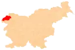
 Strmec na Predelu Location in Slovenia | |
| Coordinates: 46°24′55.88″N 13°36′33.83″E / 46.4155222°N 13.6093972°E | |
| Country | |
| Traditional region | Slovenian Littoral |
| Statistical region | Gorizia |
| Municipality | Bovec |
| Area | |
| • Total | 12.04 km2 (4.65 sq mi) |
| Elevation | 955.1 m (3,133.5 ft) |
| Population (2020) | |
| • Total | 9 |
| • Density | 0.75/km2 (1.9/sq mi) |
| [1] | |
Strmec na Predelu (pronounced [ˈstəɾməts na pɾɛˈdeːlu]; Italian: Bretto di Sopra[2]) is a settlement in the Municipality of Bovec in the Littoral region of Slovenia. It lies on the road to the Predel Pass. Another road, distinguished by being the road built at the highest elevation in Slovenia, splits off the road to Predel and leads to the lodge on Mangart Saddle.[3]
World War Two came to Strmec in 1943 when Germans accused the town of supporting partisans in the region. German soldiers killed 16 men in the town then burned down the village.
References
- ↑ Statistical Office of the Republic of Slovenia
- ↑ Flynn, Randall E., & Gerd Quinting. 1983. Gazetteer of Yugoslavia: A–L. Washington, DC: Defense Mapping Agency, p. 73.
- ↑ Mangart Saddle on Hribi.net
External links
 Media related to Strmec na Predelu at Wikimedia Commons
- Strmec na Predelu on Geopedia
| Settlements | Administrative seat: Bovec
|  Location of the Municipality of Bovec in Slovenia | ||||
|---|---|---|---|---|---|---|
| Landmarks |
| |||||
| Notable people |
| |||||
This article is issued from Wikipedia. The text is licensed under Creative Commons - Attribution - Sharealike. Additional terms may apply for the media files.