| Steyr | |
|---|---|
 | |
 | |
| Location | |
| Country | Austria |
| State | Upper Austria |
| Physical characteristics | |
| Source | |
| • location | at Hinterstoder |
| • coordinates | 47°38′32″N 14°05′05″E / 47.6422°N 14.0846°E |
| Mouth | |
• location | in Steyr into the Enns |
• coordinates | 48°02′33″N 14°25′19″E / 48.0424°N 14.4220°E |
| Length | 68.3 km (42.4 mi) [1] |
| Basin size | 917 km2 (354 sq mi) |
| Basin features | |
| Progression | Enns→ Danube→ Black Sea |
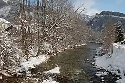
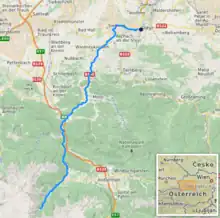
The Steyr (German: [ˈʃtaɪɐ] ⓘ) is a river in Upper Austria.[2] Its length is approx. 68 km (42 mi). Its drainage basin is 917 km2 (354 sq mi).[3]
Rising in the Totes Gebirge at Hinterstoder,[2] it flows into the Enns in the town Steyr. There both rivers form a "Y".[4] The city of Steyr uses this "Y" for marketing purposes.
Tributaries
- Krumme Steyr
- Teichl
- Krumme Steyrling
References
- ↑ DORIS Atlas (Upper Austria)
- 1 2 Google (13 February 2020). "Steyr source" (Map). Google Maps. Google. Retrieved 13 February 2020.
- ↑ "Flächenverzeichnis der Flussgebiete: Ennsgebiet" (PDF). Beiträge zur Hydrografie Österreichs Heft 61. October 2011. p. 67.
- ↑ Google (13 February 2020). "Steyr mouth" (Map). Google Maps. Google. Retrieved 13 February 2020.
External links
 Media related to Steyr River at Wikimedia Commons
This article is issued from Wikipedia. The text is licensed under Creative Commons - Attribution - Sharealike. Additional terms may apply for the media files.