Stankovany | |
|---|---|
Village | |
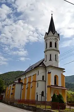 Church | |
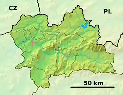 Stankovany Location of Stankovany in the Žilina Region 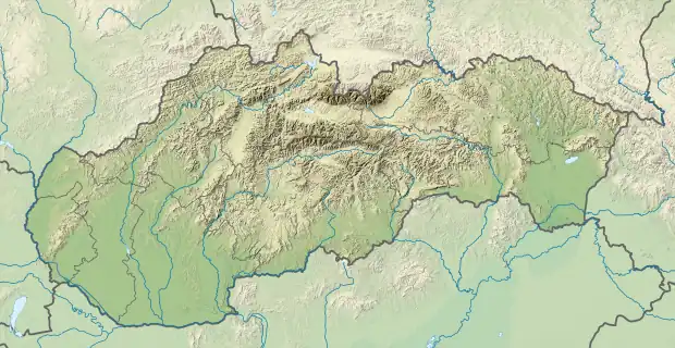 Stankovany Stankovany (Slovakia) | |
| Coordinates: 49°09′N 19°11′E / 49.150°N 19.183°E | |
| Country | Slovakia |
| Region | Žilina |
| District | Ružomberok |
| First mentioned | 1322 |
| Area | |
| • Total | 18.92[1] km2 (7.31[1] sq mi) |
| Elevation | 438[2] m (1,437[2] ft) |
| Population (2021) | |
| • Total | 1,140[3] |
| Postal code | 034 91[2] |
| Area code | +421 44[2] |
| Car plate | RK |
| Website | www.stankovany.sk/ |
Stankovany (Hungarian: Sztankován) is a village and municipality in Ružomberok District in the Žilina Region of northern Slovakia.
History
In historical records the village was first mentioned in 1322.
Geography
The municipality lies at an altitude of 649 metres (2,129 ft) and covers an area of 12.797 km2 (4.941 sq mi). It has a population of about 770 people.
References
- 1 2 "Hustota obyvateľstva - obce [om7014rr_ukaz: Rozloha (Štvorcový meter)]". www.statistics.sk (in Slovak). Statistical Office of the Slovak Republic. 2022-03-31. Retrieved 2022-03-31.
- 1 2 3 4 "Základná charakteristika". www.statistics.sk (in Slovak). Statistical Office of the Slovak Republic. 2015-04-17. Retrieved 2022-03-31.
- ↑ "Počet obyvateľov podľa pohlavia - obce (ročne)". www.statistics.sk (in Slovak). Statistical Office of the Slovak Republic. 2022-03-31. Retrieved 2022-03-31.
External links
Municipalities of Ružomberok District | ||
|---|---|---|
This article is issued from Wikipedia. The text is licensed under Creative Commons - Attribution - Sharealike. Additional terms may apply for the media files.