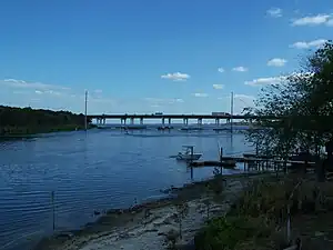
St. Johns River Veterans Memorial Bridge | |
|---|---|
 St. Johns River Veterans Memorial Bridge | |
| Coordinates | 28°50′09″N 81°19′09″W / 28.8358°N 81.3192°W |
| Carries | |
| Crosses | St. Johns River at Lake Monroe and US 17/US 92 (SR 15/SR 600) |
| Locale | Sanford, Florida and DeBary, Florida |
| Official name | St. Johns River Veterans Memorial Bridge |
| Maintained by | Florida Department of Transportation |
| ID number | 790940 |
| Characteristics | |
| Design | prestressed concrete stringer/multi-beam or girder bridge |
| Total length | 808.9 meters (2654 feet) |
| Width | 18.8 meters (62 feet) |
| Longest span | 39.6 meters (130 feet) |
| Clearance above | N/A |
| Clearance below | 13.7 meters (45 feet) |
| History | |
| Opened | 1960 (first bridge) 2004 (second bridge) |
| Location | |
The original St. Johns River Bridge was a four-lane concrete-and-steel causeway bridge constructed over the St. Johns River at the west outlet of Lake Monroe. It is a part of Interstate 4, and spans the border between Seminole and Volusia Counties in Florida, United States. On the Seminole side is Sanford and on the Volusia side is DeBary.
The bridge's design, which lacked shoulders for disabled or wrecked vehicles to pull out of the flow of traffic, made it a severe bottleneck for commuters going to the Orlando Area beginning in the 1980s. A series of fatal traffic collisions on it and similarly-designed bridges statewide, most notably the Interstate 75 Lake Panasoffkee Bridge, led to a move in 2000 to use state emergency bridge funds similar to the contingency funds used to rebuild the Sunshine Skyway Bridge to begin planned reconstruction. Work began in 2001, and a new dual structure consisting of two three-lane spans, each with wide shoulders on either side, was fully opened in May 2004.[1] The old bridge was dismantled over the next few months. Upon completion, the new structure was officially renamed the St. Johns River Veterans Memorial Bridge.
See also
References
External links